Download
Preview
Add to list
More
4.8 km
~1 hrs 11 min
137 m
Loop
“Wander shaded Catoctin woods to a cool Owens Creek pause, with a few punchy rises.”
This is a short, scenic out-and-back style walk that follows the Deerfield Nature Trail to Owens Creek, with gentle grades overall and a few slightly steeper pitches that account for most of the ~100 m (≈330 ft) of climbing. At roughly 5 km (≈3.1 mi) total, it’s a solid “medium” outing for hikers who want a forested creek destination without committing to a long mountain day.
Getting to the trailhead (car + public transport)
By car: The most common access for the Deerfield/Owens Creek area is from the Catoctin Mountain Park corridor near Thurmont, Maryland, using Park Central Road and nearby signed trail parking areas. A practical “navigate-to” landmark to aim for is Catoctin Mountain Park Visitor Center area (6602 Foxville Rd, Thurmont, MD 21788), then follow park signage toward the Deerfield/Owens Creek trail access and designated parking. Arrive early on weekends—parking fills quickly in peak leaf season and summer.
By public transport: Public transit is limited in this part of Frederick County. The most workable approach is: - MARC Train (Brunswick Line) to Frederick (or a nearby stop depending on schedules), then - a rideshare/taxi to the Catoctin Mountain Park area near Thurmont. Plan for a longer day if you’re relying on rideshare availability for the return trip.
(If you share the trailhead coordinates or a map pin, I can translate them to the nearest specific parking lot/trail access point and the closest recognizable landmark.)
What the route feels like underfoot
From the start, expect a well-established nature trail feel: packed dirt, leaf litter, and occasional roots. The first kilometer or so (0.6 mi) typically eases you into the forest with mild undulations—enough to warm up, not enough to spike your heart rate. The climbing is spread out, but you’ll notice a couple of short rises where the trail pulls away from the creek drainage and then settles back into a more level contour.
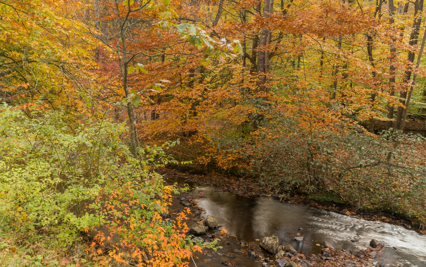
As you approach Owens Creek, the air often feels cooler and more humid, especially in the morning. The final approach tends to include slightly rockier tread and damp patches after rain. If your 5 km (3.1 mi) total includes a turnaround at the creek, the “destination moment” is usually a creekside pause—listen for moving water, look for mossy stones, and watch footing near the banks.
Navigation and wayfinding (using HiiKER)
This is generally straightforward, but intersections can be easy to drift through if you’re chatting or moving quickly. Use HiiKER to: - confirm you’re on the Deerfield Nature Trail at the start, - watch for any short connector junctions, - verify your turnaround point at Owens Creek so you don’t accidentally extend the hike onto adjacent trails.
Cell coverage can be inconsistent in folds of the mountain—download the route in HiiKER before you arrive.
Landmarks, forest character, and seasonal highlights
You’ll be walking through classic Catoctin Mountain woodland—mixed hardwood forest with a dense understory in summer and a more open, airy feel after leaf drop. Depending on season, look for: - Spring: wildflowers and fresh green canopy; creek levels are often higher. - Summer: deep shade and thicker vegetation; expect more insects near water. - Fall: strong color and busy trailheads; dry leaves can hide roots and rocks. - Winter: quieter trails; icy spots linger in shaded hollows and near the creek.
Owens Creek itself is the standout natural feature—clear moving water, rounded stones, and a riparian corridor that attracts birds and small mammals. After rain, the creek can rise and the banks can get slick; treat any informal water-edge scrambling as optional.
Wildlife and what to look out for
This area supports a typical Mid-Atlantic mix: - White-tailed deer are common, especially at dawn/dusk. - Songbirds and woodpeckers are frequent in the hardwoods. - Near the creek, you may spot amphibians (especially in wetter months).
Practical cautions: - Ticks are a real concern in Maryland woods from spring through fall—use repellent, wear long socks, and do a full check after the hike. - Poison ivy can line sunny edges and disturbed ground; learn the “leaves of three” pattern. - After storms, watch for downed limbs and slippery mud on shaded sections.
Effort, pacing, and who it suits
At ~5 km (3.1 mi) and ~100 m (330 ft) gain, most hikers can plan on 1.5–2.5 hours depending on stops at the creek and how busy the trail is. The “medium” feel usually comes from: - short, punchier rises rather than sustained climbing, - uneven footing near roots/rocks, - damp or slick sections close to water.
Gear and preparation notes
- Footwear: light hikers or trail runners work well; choose something with grip if it’s been wet.
- Water: bring at least 0.5–1 L per person for a short hike; more in summer humidity.
- Layers: the creek corridor can feel cooler than the parking area—pack a light layer even on warm days.
- Rain plan: if rain is forecast, expect muddier tread and slick rocks near Owens Creek; trekking poles can help with stability.
Historical significance of the region
Catoctin Mountain

Surfaces
Ground
Dirt
Unpaved
Asphalt
Wood
Unknown
Comments and Reviews
User comments, reviews and discussions about the Owens Creek via Deerfield Nature Trail, Maryland.
average rating out of 5
0 rating(s)