Download
Preview
Add to list
More
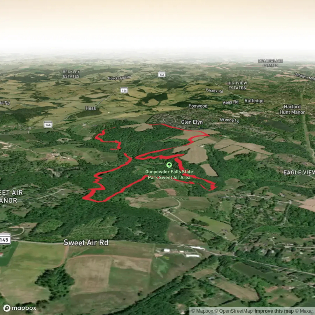
9.4 km
~2 hrs 6 min
132 m
Loop
“Wander shaded creekside woods, then roll onto the drier Boundary Trail for quiet, leafy views.”
This easy, mostly wooded out-and-back/loop-style walk follows the Little Gunpowder Falls corridor and then climbs gently onto the Boundary Trail for a higher, drier traverse before returning toward the river. Expect about 9 km (5.6 mi) with roughly 100 m (330 ft) of total ascent—more of a “rolling” hike than a sustained climb, with frequent shade and a few short, rooty rises.
Getting to the start (car + public transport)
Because the start point is listed only as “near” (no coordinates provided), the most practical way to plan is to aim for the Little Gunpowder Falls / Gunpowder Falls State Park – Hereford Area access points near the Prettyboy Reservoir / Hereford Road corridor in northern Baltimore County. If you share a longitude/latitude (or a pin), I can convert it to the nearest recognizable address/landmark and tailor the directions precisely.
- By car: Search for parking associated with Gunpowder Falls State Park (Hereford Area) trailheads along the Little Gunpowder Falls valley. Arrive early on fair-weather weekends—small lots can fill quickly.
- By public transport: Transit is limited in this semi-rural area. The most workable approach is typically bus/light rail to the northern Baltimore suburbs, then a rideshare/taxi to the Hereford-area trail access. If you tell me where you’re coming from (e.g., downtown Baltimore, Towson, Hunt Valley), I can outline the most realistic connection.
What the trail feels like underfoot
Most of this route is on packed dirt singletrack with leaf litter, interlaced roots, and occasional rocks—comfortable in trail runners or light hikers. After rain, the low sections near the creek/river can hold mud and shallow standing water, while the Boundary Trail tends to drain better. You’ll likely cross or skirt small feeder streams; water levels vary a lot seasonally.
Plan on a relaxed pace: 2–3 hours for most hikers, longer if you stop for photos, birding, or creekside breaks.
Along Little Gunpowder Falls: water, woods, and wildlife
The Little Gunpowder corridor is the star early on—cooler air, thicker canopy, and the constant presence of moving water. You’ll pass: - Creekside flats and gentle bends where the trail runs close to the water (watch footing on sloped banks). - Mixed hardwood forest typical of Maryland’s Piedmont—oak, tulip poplar, beech, and maple, with spring wildflowers and summer ferns. - Wildlife to look for: white-tailed deer, squirrels, woodpeckers, and songbirds. Near the water, you may spot great blue herons or other waders. In warmer months, expect mosquitoes in still, shaded pockets and ticks in brushy edges—use repellent and do a post-hike check.
You’ll also see subtle signs of the region’s long human history: this watershed sits in a landscape shaped by Indigenous presence, later colonial-era farming and milling, and then the growth of Baltimore’s surrounding communities. The Gunpowder watershed has been closely tied to water supply and land conservation in the region, which is a big reason these wooded corridors remain intact today.
Boundary Trail: a gentle climb to a drier traverse
At roughly the mid-hike transition, the Boundary Trail typically pulls you up and away from the water. The climb is modest—think short rises that add up to the route’s total ~100 m (330 ft) gain rather than one big hill. This section often feels: - Drier and slightly more open in places, with seasonal views through the trees. - More “roller-coaster”: small ups and downs, a few tighter turns, and more roots. - Quieter: fewer creekside stopping points, but a steadier walking rhythm.
This is where navigation can get mildly confusing if junctions are unsigned or if leaf cover hides tread. Keep HiiKER handy and confirm you’re staying on the Boundary alignment at intersections—especially if there are social paths leading toward the river.
Landmarks and points of interest to watch for
- Confluences and feeder streams: small tributaries entering Little Gunpowder Falls are good rest/photo spots; they can also be slick where the trail narrows.
- Mature forest stands: look for larger, older trees on higher ground—often a sign you’re on the Boundary segment or approaching it.
- Seasonal color: spring ephemerals (early wildflowers), summer green tunnel, and strong fall foliage are common highlights in this corridor.
Hazards and “look out for” notes (easy hike, but not risk-free)
- Slippery roots and wet leaves: the most common cause of slips, especially on shaded creekside bends.
- High water after storms: if you encounter a normally easy crossing that’s running fast, don’t force it—turn back or reroute.
- Ticks and poison ivy: poison ivy is common along sunny edges and disturbed ground; long socks help, and stay centered on the tread.
- Bikes: some Gunpowder-area trails allow multi-use; listen for riders on narrow sections and step aside on the downhill side where possible.
What to pack for a 9 km (5.6 mi) easy day hike
- Water: at least 1 liter per person (more in humid summer conditions).
- Footwear: trail runners are fine; choose something with grip if it’s been wet.
- Layers: the creek corridor can feel cooler; a

Surfaces
Ground
Dirt
Unpaved
Grass
Comments and Reviews
User comments, reviews and discussions about the Little Gunpowder Trail and Boundary Trail, Maryland.
average rating out of 5
0 rating(s)