Download
Preview
Add to list
More
9.3 km
~1 hrs 53 min
18 m
Loop
“Stroll the canal’s quiet history, then pick your way over Potomac boulders beside roaring falls.”
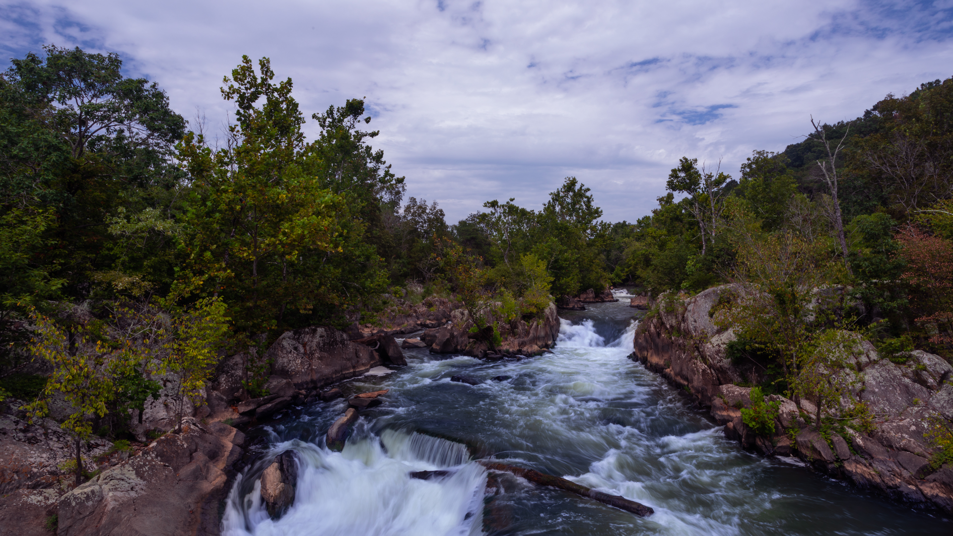
From the Great Falls area on the Maryland side of the Potomac, this loop pairs a flat, gravel towpath walk with a short, rocky riverside section of the Billy Goat Trail. At roughly 9 km / 5.6 mi with about 0 m / 0 ft of net elevation gain, it’s mostly about scenery—rushing water, canal history, and a quick taste of the area’s famous river boulders.
Getting to the start (car + public transport)
Best start point: Great Falls Tavern Visitor Center, 11710 MacArthur Blvd, Potomac, MD 20854 (inside Chesapeake & Ohio Canal National Historical Park). (midatlantichikinggroup.org)
- By car: Navigate to the address above; parking is in the Great Falls Tavern area. This is one of the most popular trail hubs in the region, so arriving early helps on weekends and pleasant-weather days. (nps.gov)
- By public transport: There isn’t a direct Metro stop at the trailhead. The most practical transit approach is Metro to the DC area + bus/ride-share to Great Falls Tavern (expect the last leg to be the limiting factor). If you’re planning a fully transit-based day, build in extra time for the final connection and have a backup plan for the return.
You’ll want HiiKER loaded before you leave the parking area—cell service can be inconsistent near the river corridor, and the towpath/Billy Goat junctions can be easy to stroll past when it’s busy.
The route is typically done as a loop: towpath out, Billy Goat back (or vice versa). The towpath is wide and straightforward; the Billy Goat segment is where footing and route-finding attention matter most.
What the hike feels like underfoot
Towpath (easy, steady):
Right away you’re on the historic C&O Canal Towpath, a long, mostly level corridor of packed dirt and gravel. It’s ideal for warming up: minimal grade, predictable footing, and plenty of room for two-way traffic (hikers, runners, and cyclists). The canal sits quietly to one side while the Potomac runs nearby, and you’ll pass classic canal features—locks, stonework, and water-control structures—woven into the woods.
Billy Goat segment (shorter, rockier):
When you peel off the towpath onto the Billy Goat Trail, the character changes fast: narrower tread, uneven rock, and occasional hands-for-balance moves over boulders near the river. Even on an “easy” plan, this portion is where you slow down. Expect slick spots after rain, and watch for sand/grit on slanted rock that can act like ball bearings.
Landmarks, scenery, and nature
Great Falls + canal structures:
The Great Falls area is a natural choke point where the Potomac drops through a rocky gorge, and the canal infrastructure here reflects how engineers worked around that terrain. The Great Falls Tavern area is also a focal point for learning the canal story and orienting yourself before you head out. (visitmaryland.org)
Bear Island corridor:
Much of the Billy Goat experience here is tied to Bear Island, the strip of land between the canal and the Potomac that concentrates both the trail and the scenery—wooded interior, then sudden openings to river rock and fast water. (en.wikipedia.org)
Wildlife and seasonal highlights:
You’re in a classic Mid-Atlantic river-and-hardwood setting. Common sightings include songbirds and water-associated birds along the river, plus deer in the quieter stretches. In warm months, ticks are a real consideration in brushy edges—long socks and a post-hike check are worth the effort. Poison ivy is also common along trail margins; stay centered on the tread where the path narrows.
History you’re walking through
The Chesapeake & Ohio Canal was built as a major 19th-century transportation project along the Potomac, ultimately running about 297 km / 184.5 mi from Georgetown (Washington, DC) to Cumberland, Maryland. (britannica.com)
Groundbreaking took place on July 4, 1828, with President John Quincy Adams participating—an indicator of how nationally

Surfaces
Ground
Dirt
Unknown
Wood
Asphalt
Comments and Reviews
User comments, reviews and discussions about the Billy Goat Trail and Chesapeake and Ohio Canal Towpath, Maryland.
average rating out of 5
0 rating(s)