Download
Preview
Add to list
More
8.8 km
~1 hrs 56 min
109 m
Loop
“Wander rolling Potomac woods to Great Falls Overlook—an easygoing loop with a showstopping finale.”
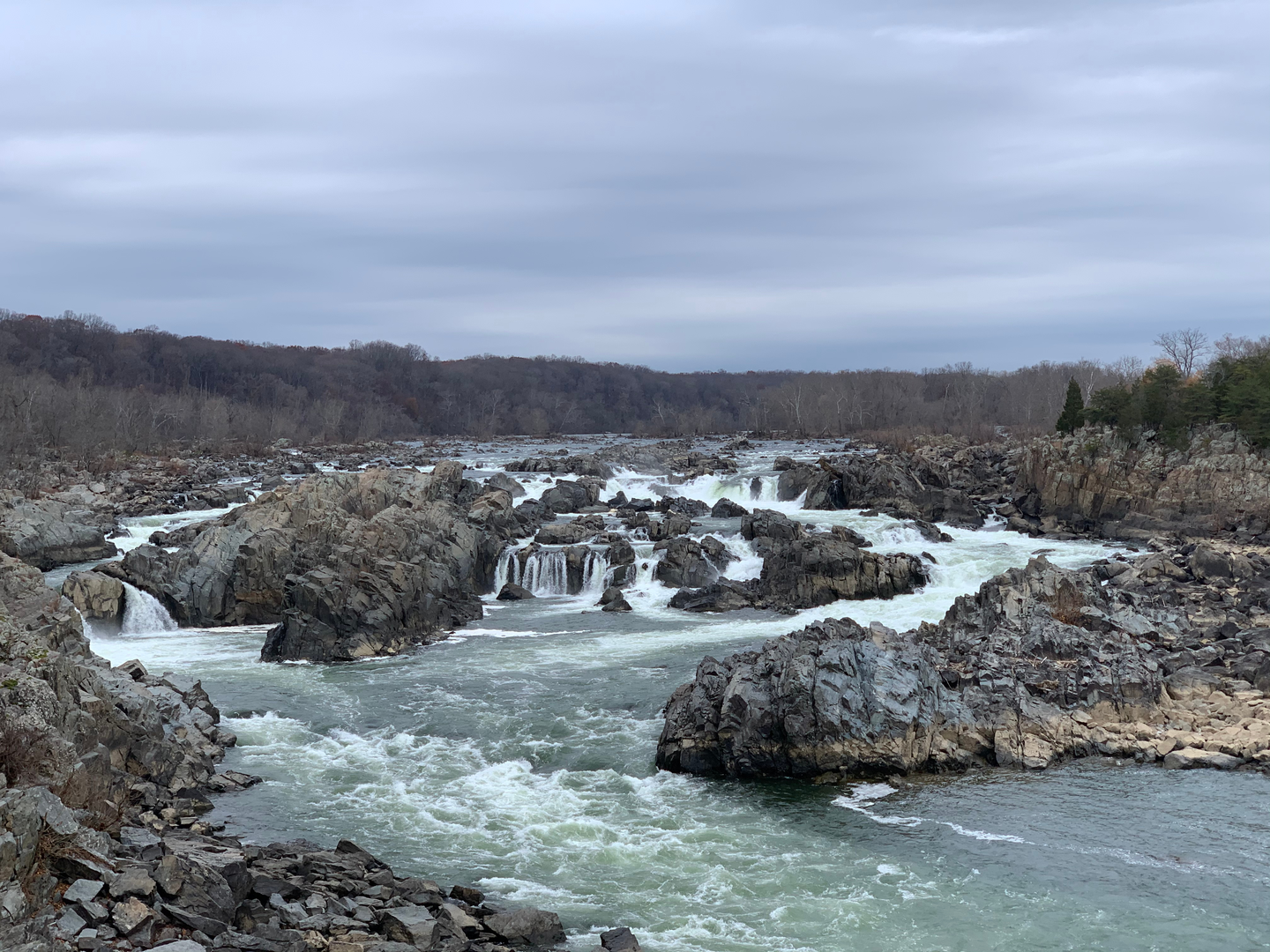
This easy loop sits on the Maryland side of the Potomac River in the Great Falls area of Chesapeake & Ohio Canal National Historical Park, mixing quiet hardwood forest, a few short ridge-and-hollow ups and downs, and a big payoff at the Great Falls Overlook. Expect roughly 9 km (5.6 mi) with about 100 m (330 ft) of total climbing—spread out in small chunks rather than one sustained hill—so it’s friendly for newer hikers, families, and anyone looking for a half-day walk with a marquee viewpoint. (Comparable mapped loops here are often listed around 4.9 mi / 291 ft.) (alltrails.com)
Nearest start landmark / address: the most common starting point for this route is the Great Falls Tavern Visitor Center, 11710 MacArthur Blvd, Potomac, MD 20854. (nps.gov)
Getting to the trailhead (car + public transport)
By car: Navigate (in HiiKER) to Great Falls Tavern Visitor Center (11710 MacArthur Blvd, Potomac, MD 20854). Parking is in the Great Falls Tavern area; this is a very popular gateway for the Great Falls section of the park, so arriving early helps on weekends and peak foliage days. (mapquest.com)
By public transport: There isn’t a direct, frequent transit stop at the visitor center itself. The most workable approach is typically Metro to Bethesda or Rockville, then a Montgomery County Ride On bus toward Potomac, followed by a rideshare/taxi for the last few miles to MacArthur Blvd. If you’re trying to minimize rideshare, another common “close-by” landmark is Old Anglers Inn (10801 MacArthur Blvd, Potomac, MD 20854), which is nearer to some canal access points than the tavern area. (oldanglersinn.com)
What the walk feels like underfoot
You’ll be on a mix of: - Packed dirt singletrack through mature woods (Gold Mine/Woodland segments), - Wider, flatter corridor paths in places (spurs and connector segments), - Shorter rocky or rooty patches where the trail cuts across slopes or drains.
After rain, low spots can hold mud, and leaf litter can hide roots—easy terrain overall, but it rewards steady footing.
Route flow and key junctions (with approximate distances)
From the Great Falls Tavern area, you’ll head into the forest on the Gold Mine Trail system, using a combination of Gold Mine and Woodland Trail connectors to build a longer loop that eventually links toward the Overlook Trail for river views and the Great Falls viewpoint. The trail network here is well-used and has multiple signed intersections (you’ll commonly see junctions for spurs like Anglers Spur and Woodland Trail), so it’s a good place to keep HiiKER handy to confirm you’re taking the intended connector at each fork. (npplan.com)
A practical way to think about the day: - 0.0–2.5 km (0.0–1.6 mi): Settle in on rolling woodland trail. You’ll gain and lose small amounts of elevation as the path weaves through a mixed forest. This is where you’ll feel most of the route’s “climbing,” but it’s broken into short rises rather than a long grind. - 2.5–5.5 km (1.6–3.4 mi): The loop portion deepens into quieter forest, passing the area associated with the historic gold mine ruins (often referenced as the “Ford Mine” in local hike descriptions). The “ruins” are subtle—more a sense of place than a dramatic structure—so it helps to know roughly where you are on HiiKER if you want to pause at the right

Surfaces
Ground
Dirt
Gravel
Unknown
Unpaved
Wood
Comments and Reviews
User comments, reviews and discussions about the Great Falls Overlook via Gold Mine and Woodland Trail, Maryland.
average rating out of 5
0 rating(s)