Download
Preview
Add to list
More
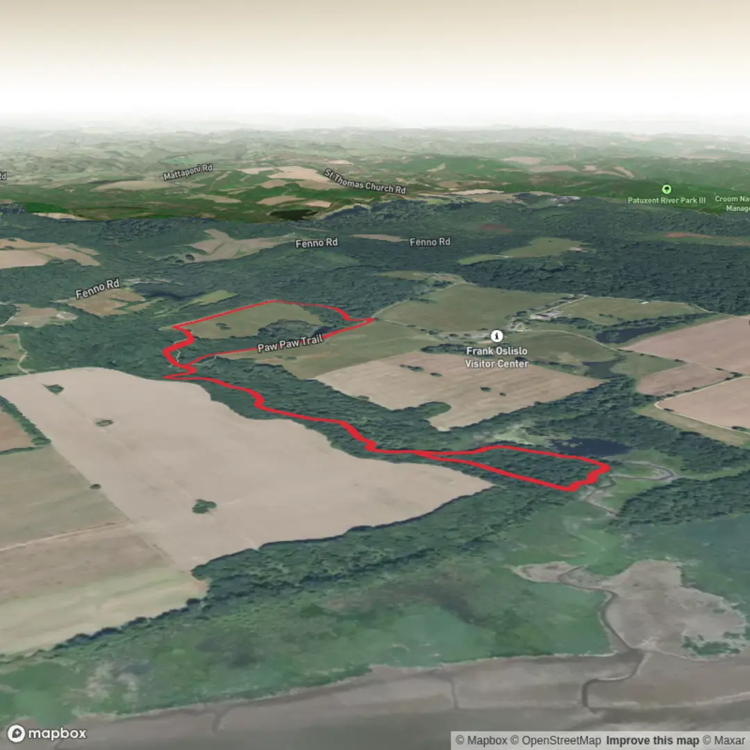
3.5 km
~41 min
0 m
Loop
“A gentle, mostly level loop through pawpaw shade and mysterious mounds, with plenty to linger over.”
A short, mostly level wander of about 3 km (1.9 mi) with ~0 m (0 ft) of climbing, this route is well-suited to families, beginners, and anyone looking for an easy nature walk with a few points of interest along the way. Expect wide, well-used paths, gentle turns, and frequent opportunities to pause for birds, wildflowers, and interpretive features if the park has them.
Getting to the trailhead (car + public transport)
Because the start location is listed only as “near” (with no coordinates or place name), I can’t reliably convert it to a nearest address or landmark yet. If you share a lon/lat pair (or even a park name/city), I’ll pin it to the closest recognizable trailhead/parking area and tailor directions precisely.
For planning purposes, here’s what typically works best for easy loop systems like Paw Paw + Mounds:
- By car: Look for the primary park entrance / main day-use parking lot closest to the Paw Paw Trail access. Arrive earlier on weekends—small trail systems can fill quickly even when the hike is short. If there are multiple lots, choose the one that has a posted map kiosk so you can confirm the Paw Paw–Mounds connection before you start.
- By public transport: If the area is served by buses or rail, the most reliable approach is to route to the nearest stop by the main park entrance and walk in. Short trail networks are often set back from roads; budget extra time for the walk from the stop to the trailhead (often 0.5–2.0 km / 0.3–1.2 mi each way).
If you tell me the nearest town/park name (or coordinates), I’ll specify the best parking lot, the closest transit stop, and the most efficient walking approach.
From the trailhead, you’ll usually start on the Paw Paw Trail—often a straightforward, gently curving path through lowland vegetation. With negligible elevation change, the main “effort” here is simply steady walking and keeping an eye on trail junctions. On a 3 km (1.9 mi) outing, most hikers will be moving for 40–70 minutes depending on stops.
The Paw Paw portion commonly passes through mixed understory where pawpaw trees thrive: look for broad, drooping leaves and (in season) the distinctive greenish-purple pawpaw flowers or the oblong fruit later in the year. Even when fruit isn’t present, pawpaw groves often create a slightly shaded, tunnel-like feel along the path. Wildlife tends to be subtle rather than dramatic—expect songbirds, woodpeckers, and small mammals. In warmer months, this kind of habitat can also mean mosquitoes and ticks, especially if the trail edges brush your legs; long socks and a quick tick check afterward are smart.
At roughly 1.0–1.5 km (0.6–0.9 mi) in (depending on where you start), you’ll likely reach a signed junction or a clear change in trail character where the route transitions toward the Mounds Trail. Use HiiKER to confirm you’re taking the correct connector—short trail systems can have multiple spurs that look equally “main.”
The Mounds section: what the “mounds” usually mean
“Mounds Trail” often indicates one of two things:
1) Archaeological or cultural earthworks (constructed mounds), or
2) Natural mounding (glacial deposits, old dune forms, or floodplain features)
If these are cultural/archaeological mounds, treat them as protected heritage features: stay on the tread, don’t climb on steep sides, and avoid cutting corners that cause erosion. Many mound sites in North America are associated with long histories of Indigenous land use and ceremonial or community functions; even when signage is minimal, the presence of maintained mounds typically reflects recognized cultural significance and ongoing stewardship.
If the mounds are natural, you’ll notice gentle rises and dips rather than true “hills”—still consistent with the stated ~0 m / 0 ft gain overall. These subtle undulations can change drainage: after rain, low spots may hold water and become slick. Footing is usually easy, but watch for mud patches, roots, and leaf litter that can hide uneven ground.
Landmarks on this section are often the mounds themselves (sometimes numbered or interpreted), plus occasional clearings that make good rest spots. If there are interpretive signs, they’re worth a pause—on a short hike, those details are often the highlight.
As you complete the loop or out-and-back, you’ll rejoin the Paw Paw Trail or return via a connector. Plan for the final 0.5–1.0 km (0.3–0.6 mi) to feel quicker as you near the trailhead, but keep your attention at junctions—many easy trails have multiple “almost right” turns near parking areas.
What to look out for (easy hike, common surprises): - Junction confusion: Use HiiKER at every signed intersection; short networks can be surprisingly maze-like. - Bugs and ticks: Especially in warm months and near damp lowlands. - Soft ground after rain: Low-lying trails can stay muddy longer than expected even with no elevation gain. - Wildlife etiquette: Give birds and small mammals space; keep voices low if you’re hoping to spot more activity.
If you share the missing start details (a lon/lat or the park/city), I’ll convert it to the nearest known address/landmark and tighten the

Comments and Reviews
User comments, reviews and discussions about the Paw Paw Trail and Mounds Trail, Maryland.
average rating out of 5
0 rating(s)