Download
3D Flyover
Add to list
More
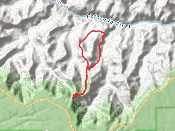
26.1 km
~2 days
1564 m
Multi-Day
“Trek through the Grand Canyon's heart on a storied and scenic 16-mile journey demanding preparation and stamina.”
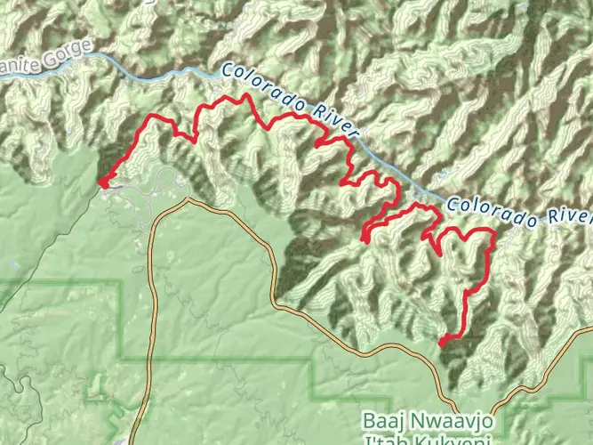
Embarking on the Grandview Trail to New Hance Trail, hikers will traverse approximately 26 kilometers (about 16 miles) of rugged terrain within the Grand Canyon National Park. This point-to-point journey begins near Coconino County, Arizona, and boasts an elevation gain of around 1500 meters (roughly 4900 feet), presenting a medium difficulty rating that requires good physical condition and preparation.
Getting to the Trailhead
The trailhead is accessible by car, located off the Desert View Drive, also known as East Rim Drive. If you're coming from Grand Canyon Village, it's about a 12 km (7.5 miles) drive east to the Grandview Point turnoff. There is a parking area where you can leave your vehicle before starting the hike. Public transportation options are limited, so driving or arranging a shuttle service is recommended.
The Journey Begins
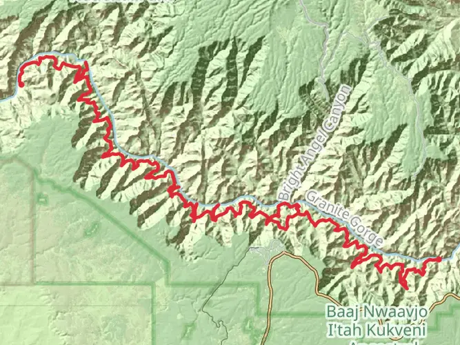
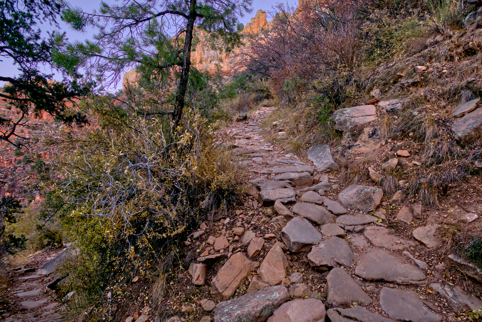
Starting from the Grandview Point, the trail descends steeply through the Coconino sandstone and into the canyon, offering breathtaking panoramic views. The initial descent is quite challenging, with a series of tight switchbacks and some exposure to heights. Hikers should be cautious, as the path can be slippery due to loose rocks and gravel.
Historical Significance
As you navigate the trail, you're following in the footsteps of miners from the late 1800s. The Grandview Trail was originally developed to reach the Last Chance copper mine. Remnants of the mining era, including old structures and rusted equipment, can still be seen, providing a glimpse into the past.
Landmarks and Natural Features
After descending the initial switchbacks, the trail levels out somewhat as it crosses Horseshoe Mesa. This flat stretch allows for a brief respite before the descent continues. The mesa itself offers historic sites, including old mine entrances and the remnants of miners' cabins.
Continuing the descent, the trail becomes less defined and more rugged. Hikers will need to navigate through the Tonto Group rock formations, which can be challenging and require careful attention to the cairns marking the way. The use of a navigation tool like HiiKER is highly recommended to stay on track.
Wildlife and Vegetation
The diverse ecosystems of the Grand Canyon are on full display along the trail. Keep an eye out for mule deer, bighorn sheep, and a variety of bird species. The plant life is equally varied, with cacti, wildflowers, and shrubs that change with the elevation.
The Final Stretch
As you approach the New Hance Trail, the path becomes steeper and more strenuous. This section is known for its redwall limestone cliffs and requires careful navigation through a series of switchbacks. The New Hance Trail is considered one of the more difficult routes within the Grand Canyon due to its steep, rocky, and often poorly defined path.
Preparation and Safety
Due to the trail's difficulty and remote nature, it is essential to be well-prepared with adequate water, food, and gear. The weather can change rapidly, so layered clothing is advisable. It's also important to inform someone of your hiking plans and expected return time.
Conclusion
The Grandview Trail to New Hance Trail offers an immersive experience into the heart of the Grand Canyon, with historical artifacts, stunning geological formations, and a variety of flora and fauna. It's a challenging hike that rewards the prepared adventurer with unforgettable views and a sense of accomplishment.

What to expect?
Activity types
Frequently asked questions
How hard is the Grandview Trail to New Hance Trail in Grand Canyon National Park?
Grandview Trail to New Hance Trail is a 26.11 km point-to-point backcountry route with about 1,564 m of elevation gain, so it belongs firmly in the extra difficult category. The route links two of the South Rim’s steepest and roughest established trails, with long descents and climbs, exposed sections, and demanding footing that suit experienced canyon hikers.
Where do you park for the Grandview Trail to New Hance Trail hike?
The usual start is Grandview Point on Desert View Drive, where the historic Grandview Trail begins. Grandview Point sits about 10.2 miles east of Grand Canyon Village and has parking, vault toilets, and the trailhead at the overlook area. Because it is one of the South Rim’s most popular viewpoints, parking can fill and the area can feel congested.
Do you need a permit to backpack the Grandview Trail to New Hance Trail?
Yes. This is a multi-day below-the-rim route, and Grand Canyon National Park requires a backcountry permit for any camping below the rim. That matters on this route because the distance, elevation change, and point-to-point layout make it a backpacking trip for most parties rather than a casual day hike.
Is there water on the Grandview Trail to New Hance Trail route?
Water planning is critical on Grandview Trail to New Hance Trail. There is no drinking water available on the Grandview Trail to Horseshoe Mesa, and springs below the mesa are not considered reliable. NPS materials identify Hance Creek as a permanent water source, but treatment is still necessary and current conditions should be checked before starting.
What landmarks do you pass on the Grandview Trail to New Hance Trail?
The route starts at Grandview Point on the South Rim, descends the historic Grandview Trail, and passes through the Horseshoe Mesa area, which is tied to late-1800s copper mining. It then continues through the Hance Creek area before climbing out on the New Hance Trail, a rugged South Rim route known for difficult route-finding through parts of the Supai section.
Is the Grandview Trail to New Hance Trail a loop or a point-to-point hike?
Grandview Trail to New Hance Trail is a point-to-point route, not a loop. It begins at Grandview Point and finishes at the New Hance Trailhead area on the South Rim, so a car shuttle or other pickup plan is usually needed unless the route is being combined with additional rim travel.
When is the best time of year to hike the Grandview Trail to New Hance Trail?
Spring and fall are generally the safest seasons for Grandview Trail to New Hance Trail because the route is steep, exposed, and largely without shade on the upper sections. NPS warns that the Grandview Trail is in full sun in summer, while winter ice and snow can make the upper trail treacherous, especially near Grandview Point at roughly 7,400 feet.
Comments and Reviews
User comments, reviews and discussions about the Grandview Trail to New Hance Trail, Arizona.
4.67
average rating out of 5
3 rating(s)