Download
3D Flyover
Add to list
More
32.8 km
~2 days
1510 m
Multi-Day
Embarking on the Rim to Rim Trail in Grand Canyon National Park is a journey through one of the most iconic landscapes in the United States. This approximately 33 km (20.5 miles) trek traverses the Grand Canyon from the North Rim to the South Rim, offering hikers a challenging and rewarding experience with an elevation gain of around 1500 meters (nearly 5000 feet).
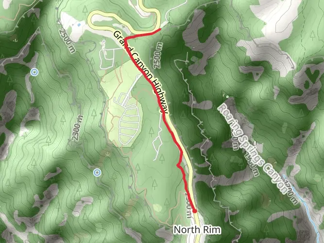
Getting to the Trailhead The Rim to Rim Trail can be accessed from either the North or South Rim. Most hikers start from the North Rim, which is less crowded. The North Rim trailhead is located near Coconino County, Arizona. If you're driving, you can reach the North Kaibab Trailhead by taking Highway 67 south from Jacob Lake. For those using public transport, there are shuttle services available from major cities to the Grand Canyon, and then you can use the Trans-Canyon Shuttle to get to the North Rim.
North Kaibab Trail to Phantom Ranch The journey begins at the North Kaibab Trailhead, where the path descends into the canyon. The first major landmark you'll encounter is Roaring Springs, about 7 km (4.3 miles) down the trail, which is a vital water source for the park. As you continue, you'll pass through the Supai Tunnel and descend the Redwall limestone, which offers dramatic views of the canyon's geological layers.
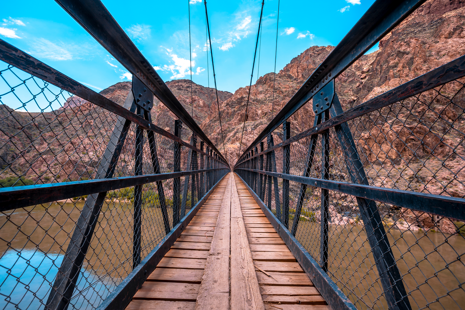
Phantom Ranch to Bright Angel Trailhead After approximately 22 km (13.7 miles), you'll reach Phantom Ranch, nestled at the bottom of the canyon near the Colorado River. This is the only lodging below the rim and a good place to rest or stay overnight. From Phantom Ranch, you'll follow the River Trail for 3 km (1.9 miles) before beginning your ascent on the Bright Angel Trail.
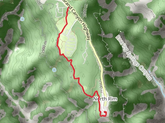
The Ascent to the South Rim The climb to the South Rim is strenuous, with an elevation gain of over 1300 meters (4265 feet) in the last 9.5 km (5.9 miles). Along the way, you'll pass Indian Garden, an oasis 7.5 km (4.7 miles) from the South Rim, where you can find water and shade. The final push to the South Rim is the most challenging part of the hike, with steep switchbacks leading up to the trailhead.
Flora, Fauna, and Landmarks Throughout the hike, you'll encounter a variety of ecosystems, from alpine forests to desert scrub. The trail is home to diverse wildlife, including mule deer, bighorn sheep, and the endangered California condor. Significant landmarks include the Great Unconformity, where you can see a gap in the geological record, and the Vishnu Schist, some of the oldest exposed rock in the canyon.
Historical Significance The Grand Canyon holds deep historical and cultural significance. For thousands of years, Native American tribes have considered this land sacred. The trails you'll hike on were developed from routes used by indigenous peoples. The park itself was established in 1919 and is a testament to the conservation efforts that have preserved its beauty for future generations.
Preparation and Planning Due to the trail's difficulty and the extreme weather conditions that can occur in the canyon, it's essential to plan and prepare thoroughly. Ensure you have a detailed map, which you can obtain through the HiiKER app, and check the weather forecast before your hike. Carry plenty of water, high-energy food, and be prepared for temperature extremes. It's also wise to arrange for transportation back to your starting point, as this is a point-to-point hike.
Remember, the Rim to Rim Trail is not just a hike; it's an adventure through time, showcasing the natural wonders and the rich history of the Grand Canyon.

What to expect?
Activity types
Frequently asked questions
How long is the Rim to Rim Trail in Grand Canyon National Park?
The Rim to Rim Trail is about 32.83 km, or 20.5 miles, crossing the Grand Canyon between the North Rim and South Rim. Most hikers link the North Kaibab Trail with the Bright Angel Trail, passing Phantom Ranch and the Colorado River on the way between the two rims.
How hard is the Rim to Rim Trail and how much climbing does the Rim to Rim Trail have?
The Rim to Rim Trail is an extra difficult multi-day hike with roughly 1,510 m of elevation gain, about 4,954 feet. Even though one direction is mostly downhill at first, the route still includes a long, punishing climb out of the canyon, major heat exposure near the river, and a full canyon crossing.
Where do most hikers start the Rim to Rim Trail and where does the Rim to Rim Trail finish?
Most classic Rim to Rim hikes start at the North Kaibab Trailhead on the North Rim and finish at Bright Angel Trailhead on the South Rim. That direction is popular because the North Rim trailhead sits higher, around 8,241 feet, and the route descends to the Colorado River before climbing back to the South Rim.
Is there parking for the Rim to Rim Trail at Bright Angel Trailhead and North Kaibab Trailhead?
On the South Rim, Bright Angel Trailhead parking is limited, and the National Park Service lists Lot D near the Backcountry Information Center as a practical place to park, with a short 0.4 mile walk to the trailhead. On the North Rim, hikers commonly use the North Kaibab Trailhead area, but vehicle logistics are the bigger challenge because the two rims are far apart by road.
Is there a shuttle for the Rim to Rim Trail between the South Rim and North Rim?
Yes. Trans-Canyon Shuttle runs scheduled rim-to-rim service between Grand Canyon Village on the South Rim and North Rim stops including Jacob Lake, Kaibab Lodge, and the North Kaibab Trailhead. That shuttle is one of the standard ways hikers solve the point-to-point transportation problem for a Rim to Rim crossing.
Are dogs allowed on the Rim to Rim Trail in Grand Canyon National Park?
No. Pets are not allowed below the rim on Grand Canyon inner-canyon trails, so dogs cannot do the Rim to Rim Trail. Grand Canyon National Park allows pets on leash above the rim in developed areas and on the Rim Trail, but not on the North Kaibab or Bright Angel trails used for a rim-to-rim hike.
Is water available on the Rim to Rim Trail from North Kaibab to Bright Angel?
Water availability on the Rim to Rim Trail can change, so it cannot be assumed. As of the latest National Park Service update for the North Kaibab Trail, potable water was only available at Manzanita Rest Area, with no water available on the North Rim itself, making careful water planning essential for a full crossing.
Comments and Reviews
User comments, reviews and discussions about the Rim to Rim Trail, Arizona.
4.25
average rating out of 5
4 rating(s)