Download
Preview
Add to list
More
26.6 km
~2 days
955 m
Multi-Day
“Embark on a scenic 17-mile trek through history and nature from Meeks Bay to Emerald Bay in California's Sierra Nevada.”
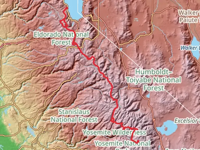
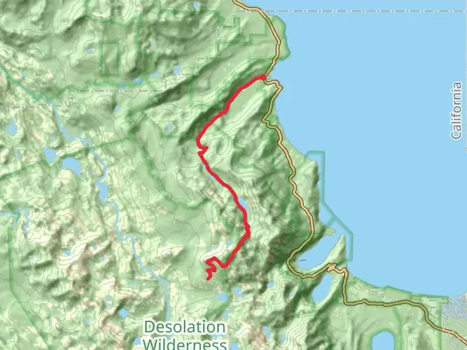
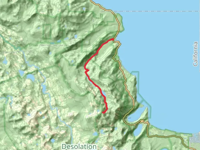
Embarking on the Meeks Bay to Emerald Bay trail, hikers will traverse approximately 27 kilometers (about 17 miles) of diverse terrain, with an elevation gain of around 900 meters (nearly 3000 feet). This point-to-point trail is nestled near El Dorado County, California, and is considered difficult due to its length and elevation profile.
Getting to the Trailhead To reach the starting point at Meeks Bay, hikers can drive to the Meeks Bay Trailhead, which is located off Highway 89. For those relying on public transportation, options may be limited, and it's advisable to check local transit resources for the most current schedules and routes. Parking is available near the trailhead, but it's wise to arrive early during peak season to secure a spot.
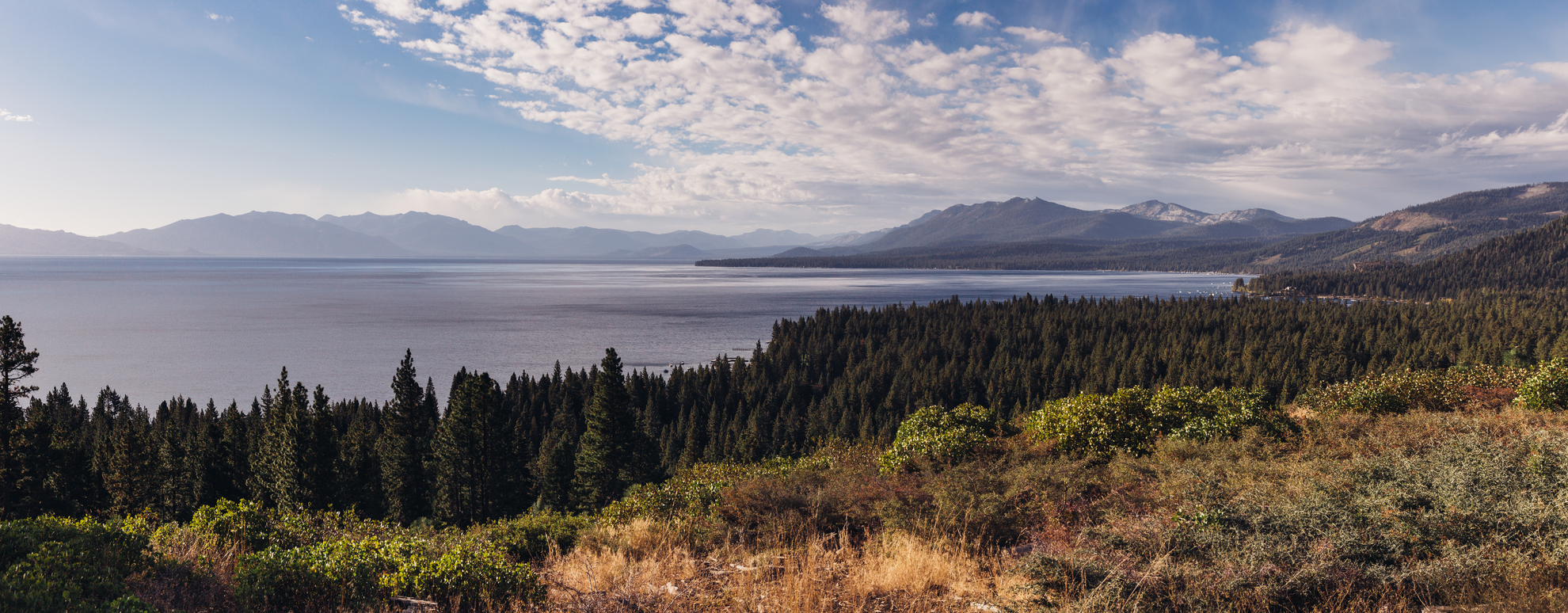
The Journey Begins The trail kicks off near the shores of Meeks Bay, where the clear waters of Lake Tahoe greet adventurers. The initial segment of the hike is a gentle ascent through a mixed conifer forest, offering a shaded canopy that provides respite from the sun. As you progress, the climb becomes more pronounced, and the forest opens up to reveal stunning vistas of the surrounding Sierra Nevada mountains.
Landmarks and Natural Beauty One of the first significant landmarks encountered is Crag Lake, nestled about 6.5 kilometers (4 miles) into the hike. This serene alpine lake is a perfect spot for a rest and a photo opportunity. Continuing on, the trail meanders through meadows dotted with wildflowers, especially vibrant during the spring and early summer months.
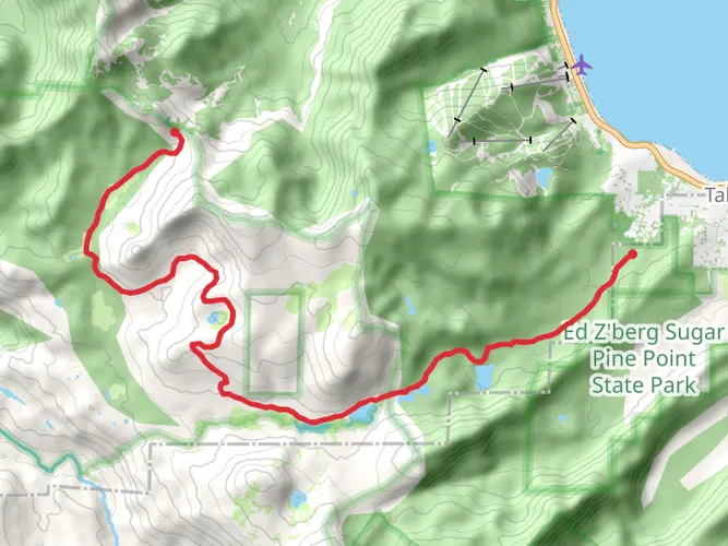
Historical Significance The region is rich in history, with the trail itself following paths once used by the Washoe Native American tribe. Emerald Bay, the endpoint of the hike, is home to the Vikingsholm Castle, an impressive example of Scandinavian architecture dating back to 1929. This historic mansion is considered one of the finest examples of a Scandinavian home in the United States and is a must-see for history enthusiasts.
Wildlife Encounters As you hike, keep an eye out for the diverse wildlife that inhabits the area. It's not uncommon to spot mule deer, black bears, and a variety of bird species. Remember to keep a safe distance from wildlife and to store food properly to avoid attracting bears.
Navigation and Preparation Given the trail's difficulty and length, it's crucial to be well-prepared with adequate water, food, and layers of clothing to adapt to changing weather conditions. For navigation, HiiKER is an excellent tool to help stay on track and be aware of upcoming terrain changes and points of interest.
Approaching Emerald Bay As you near the end of the trail, the descent into Emerald Bay offers breathtaking views of the crystal-clear waters and Fannette Island, the only island in Lake Tahoe. The final stretch can be steep, so take care with footing.
Arrival and Transportation from Emerald Bay Upon reaching Emerald Bay, hikers can explore the area or arrange for pick-up. If you've parked at Meeks Bay, you'll need to coordinate transportation back to your vehicle, as this is a point-to-point trail. Local shuttle services or taxis may be available, but it's wise to arrange this in advance.
Remember, this trail is not a loop, so planning for transportation at the end of the hike is as important as preparing for the hike itself. With its challenging terrain, historical landmarks, and stunning natural beauty, the Meeks Bay to Emerald Bay trail offers an unforgettable experience for those who undertake its journey.

What to expect?
Activity types
Frequently asked questions
How long is the Meeks Bay to Emerald Bay hike and how hard is it?
The Meeks Bay to Emerald Bay hike is 26.62 km, or about 16.5 miles, with 955 m of elevation gain. It is rated difficult, and the combination of distance, sustained climbing, and backcountry terrain makes it better suited to strong hikers or backpackers than to casual day walkers.
How long does the Meeks Bay to Emerald Bay hike usually take?
Most hikers should plan on this as a full-day effort or a short backpacking trip. At 26.62 km with 955 m of ascent, strong day hikers may finish in roughly 8 to 11 hours, while many parties split it into two days to allow time for breaks, navigation, and lake or ridge stops along the route.
Where do you park for the Meeks Bay to Emerald Bay hike?
The usual western start is Meeks Bay Trailhead on Highway 89 on the west shore of Lake Tahoe. The Forest Service lists seasonal parking at the trailhead, restrooms on site, no potable water, no fee, and day use only at the trailhead itself, so overnighting in the parking area is not allowed.
Do you need a permit for the Meeks Bay to Emerald Bay hike?
Yes. This route enters Desolation Wilderness, where permits are required year-round for both day use and overnight trips. Overnight use is subject to quota controls in the main season, and overnight visitors must also carry a hard-sided bear-resistant canister for food and scented items.
Can you camp on the Meeks Bay to Emerald Bay hike?
Camping is possible on the Meeks Bay to Emerald Bay hike because it travels through Desolation Wilderness, but overnight camping requires a valid wilderness permit. Campfires are prohibited in Desolation Wilderness, and campsites must be chosen on durable surfaces at least 100 feet from water and trails.
Are dogs allowed on the Meeks Bay to Emerald Bay hike?
Dogs are generally allowed in Desolation Wilderness, which includes the Meeks Bay to Emerald Bay hike, but they need to be under control and managed responsibly around other hikers, stock, and wildlife. Because the route is long, rocky, and strenuous, it is best suited to trail-experienced dogs that can handle a difficult 26.62 km outing.
What are the main landmarks on the Meeks Bay to Emerald Bay hike?
A key landmark on the route is Crag Lake, reached about 6.5 km, or 4 miles, from Meeks Bay. The hike also passes through classic Desolation Wilderness terrain with mixed conifer forest, alpine meadows, granite country, and expanding views toward Lake Tahoe before finishing near Emerald Bay.
Comments and Reviews
User comments, reviews and discussions about the Meeks Bay to Emerald Bay, California.
4.67
average rating out of 5
3 rating(s)