Download
Preview
Add to list
More
48.2 km
~3 days
1681 m
Multi-Day
“Trek the King Range Wilderness Loop for a rugged, breathtaking journey through California's untouched coastal majesty.”
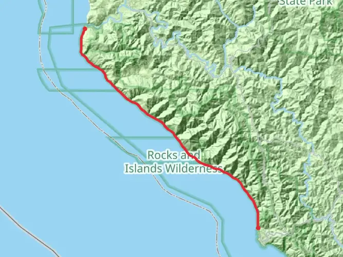
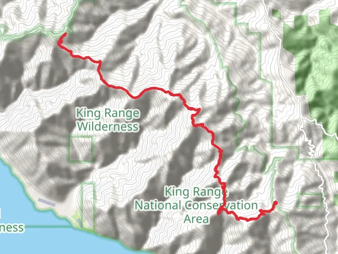
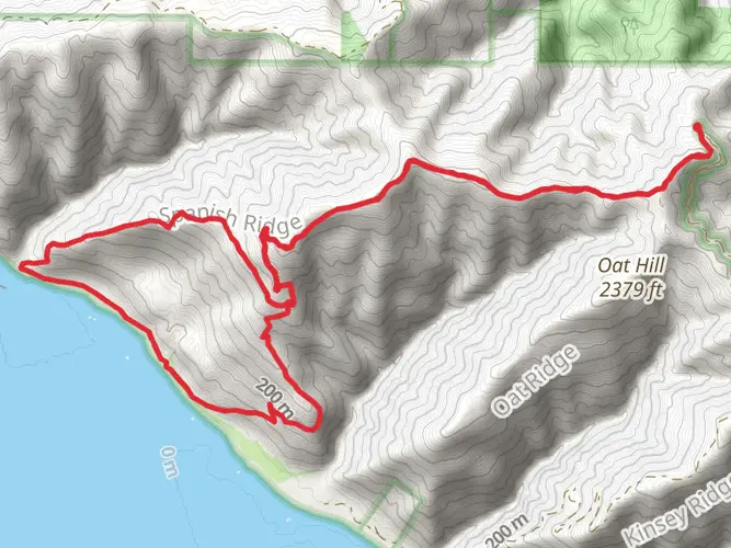
The King Range Wilderness Loop is a challenging and rewarding trek nestled in the heart of California's Lost Coast, near Humboldt County. Spanning approximately 48 kilometers (30 miles) with an elevation gain of around 1600 meters (5250 feet), this loop trail offers hikers a unique blend of coastal and mountainous terrain, providing a true wilderness experience.
Getting to the Trailhead
To reach the trailhead, you can drive to the King Range National Conservation Area, which is located about a 5-hour drive north of San Francisco. The closest significant landmark to the trailhead is Shelter Cove, a small seaside community. If you're relying on public transportation, options are limited due to the remote nature of the area. However, you can take a bus to Garberville and then arrange for a taxi or shuttle service to take you the remaining distance to the trailhead.
The Hike Itself
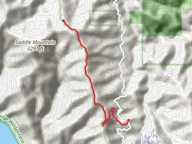
The loop typically begins at the Black Sands Beach near Shelter Cove, where the trailhead is marked. From here, hikers will traverse a variety of landscapes including high mountain ridges, forested slopes, and pristine beaches. The trail is well-marked, but due to the remote nature of the area, it's advisable to use a navigation tool like HiiKER to keep track of your progress and ensure you stay on the correct path.
Landmarks and Scenery
As you embark on the loop, you'll be greeted by the rugged coastline with its dramatic cliffs and the thunderous Pacific Ocean. The trail then leads inland, ascending into the King Range mountains where you'll encounter Douglas fir and madrone forests, open grasslands, and wildflower-covered hillsides in the spring.
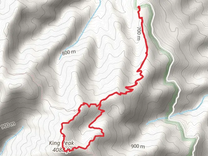
One of the most significant landmarks you'll encounter is King Peak, the highest point in the range at 1,299 meters (4,265 feet). The ascent to King Peak is strenuous but offers panoramic views of the entire wilderness area and the coastline.
Wildlife and Nature
The King Range Wilderness is home to a diverse array of wildlife. Keep an eye out for black bears, Roosevelt elk, and mountain lions, which are all native to the area. Birdwatchers will also enjoy the variety of species, including the peregrine falcon and the spotted owl. The region's streams and rivers are habitats for salmon and steelhead trout, especially in the Mattole River.
Historical Significance
The King Range area is steeped in history, with the Chumash and Sinkyone Native American tribes having inhabited the region for thousands of years. The remote nature of the Lost Coast has largely kept it undeveloped, preserving its natural and historical essence. The area was also part of the early 20th-century homesteading and logging industries, remnants of which can still be seen along the trail.
Preparation and Planning
Given the trail's difficulty rating and remote location, it's essential to be well-prepared. Hikers should carry a detailed map, plenty of water, food, and appropriate gear for sudden weather changes. It's also important to be prepared for the physical demands of the hike, as the trail includes steep and rugged sections that can be challenging.
Trail Etiquette and Conservation
As with any wilderness area, it's crucial to practice Leave No Trace principles to preserve the environment. Pack out all trash, camp in designated areas, and be respectful of wildlife and other hikers. The King Range Wilderness is a protected area, and its pristine condition is a result of the conscientious behavior of its visitors.
Embarking on the King Range Wilderness Loop is an adventure that offers solitude, natural beauty, and a sense of accomplishment for those who complete it. With careful planning and respect for the environment, hikers can enjoy one of California's most spectacular and untouched landscapes.

What to expect?
Activity types
Frequently asked questions
How long is the King Range Wilderness Loop and how hard is it?
The King Range Wilderness Loop is 48.22 km, or about 30 miles, with 1,681 meters of elevation gain. It is a difficult multi-day route, and the combination of steep climbing, remote terrain, and long stretches between access points makes it a serious backpacking trip rather than a casual day hike.
Where does the King Range Wilderness Loop start near Shelter Cove?
The King Range Wilderness Loop is commonly started from the Black Sands Beach trailhead near Shelter Cove in the King Range National Conservation Area. Black Sands Beach is one of the main access points for the Lost Coast side of the route, and it puts the loop close to the rugged shoreline that defines this part of Humboldt County.
Do I need a permit for the King Range Wilderness Loop?
An overnight permit is required for backcountry use in the King Range Wilderness and Backcountry Management Zone, which includes Lost Coast routes in the King Range National Conservation Area. Because the King Range Wilderness Loop is a multi-day trip, permit planning is an important part of the route, especially in busier seasons when quotas apply.
Is the King Range Wilderness Loop affected by tides or winter storms?
Yes. Parts of the coastal trail system in the King Range area can become dangerous or impassable during high surf and winter storms, even when tide levels might otherwise seem manageable. On a loop that links beach and upland terrain, ocean conditions are a real safety factor, especially on the Lost Coast sections near Black Sands Beach.
Can I camp at the Black Sands Beach trailhead for the King Range Wilderness Loop?
No camping is allowed at the Black Sands Beach trailhead itself. Overnight stays for the King Range Wilderness Loop need to be planned in permitted backcountry camping areas within the King Range Wilderness rather than at the trailhead parking area near Shelter Cove.
What is the best time of year to hike the King Range Wilderness Loop?
Late spring through early fall is generally the most practical window for the King Range Wilderness Loop, when weather and trail conditions are usually more stable. Winter can bring storms and heavy surf to the Lost Coast, and the Bureau of Land Management warns that these conditions can make sections of trail dangerous or impossible to pass.
Is there parking for the King Range Wilderness Loop at Black Sands Beach?
Yes, Black Sands Beach functions as a trailhead access point for King Range trips and is the usual parking area for hikers starting this loop from the Shelter Cove side. Parking logistics should still be checked before departure because this is a remote area with limited services and no trailhead camping.
Can I reach the King Range Wilderness Loop without a car?
Reaching the King Range Wilderness Loop without a car is possible but difficult because Shelter Cove and Black Sands Beach are remote. Public transit connections are limited in this part of Humboldt County, so most non-driving itineraries involve getting as far as the U.S. 101 corridor first and then arranging the final leg to Shelter Cove separately.
Comments and Reviews
User comments, reviews and discussions about the King Range Wilderness Loop, California.
4.67
average rating out of 5
6 rating(s)