Download
Preview
Add to list
More
75.1 km
~5 days
2551 m
Multi-Day
“Embark on a breathtaking 47-mile trek through Yosemite's raw beauty, history, and diverse ecosystems.”
Embarking on the Kerrick Canyon and Matterhorn Canyon Loop is a journey through the rugged and pristine wilderness of the Yosemite National Park backcountry. This approximately 75 km (around 47 miles) trek offers an elevation gain of about 2500 meters (roughly 8200 feet), presenting a challenging adventure for even seasoned hikers.
Getting to the Trailhead
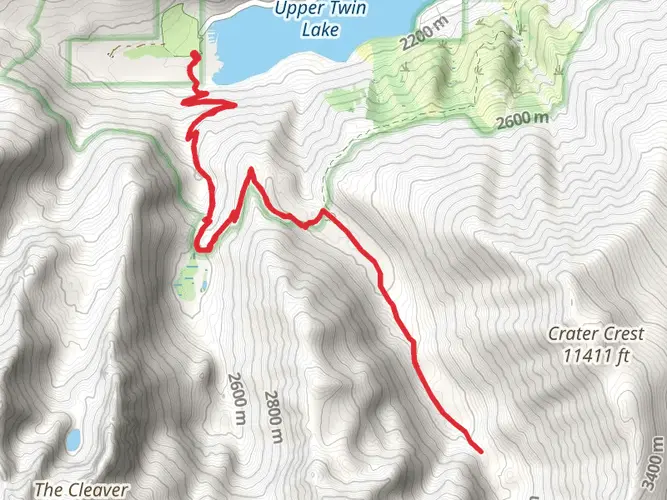
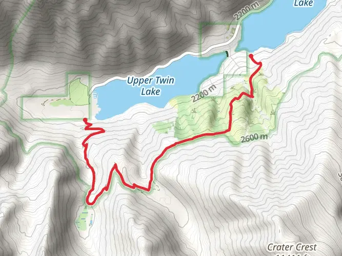
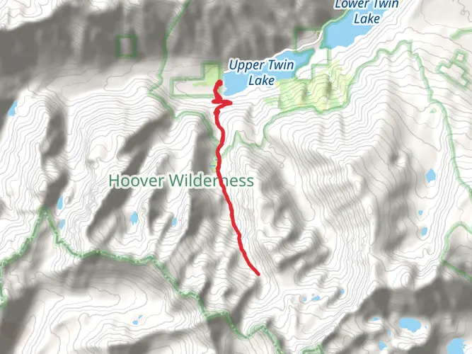
The trailhead is located near Mono County, California, in the northern reaches of Yosemite National Park. Accessing the start of the hike requires a drive to the Twin Lakes area, which is the closest landmark to the trailhead. From the town of Bridgeport, take Twin Lakes Road for about 14 miles until you reach the Mono Village resort at the end of the road. Parking is available here, and it's a short walk to the trailhead. For those relying on public transportation, options are limited, and it's often necessary to arrange a private shuttle or taxi from nearby towns.
Navigating the Trail
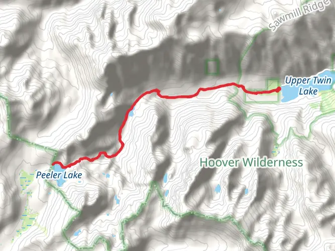
Hikers should prepare to use the HiiKER app for navigation, as the trail can be challenging to follow in places. The loop can be tackled in either direction, but many choose to head north towards Peeler Lake, which is a stunning alpine lake about 11 km (7 miles) from the trailhead. This section of the trail offers a gradual ascent, allowing hikers to acclimate to the elevation.
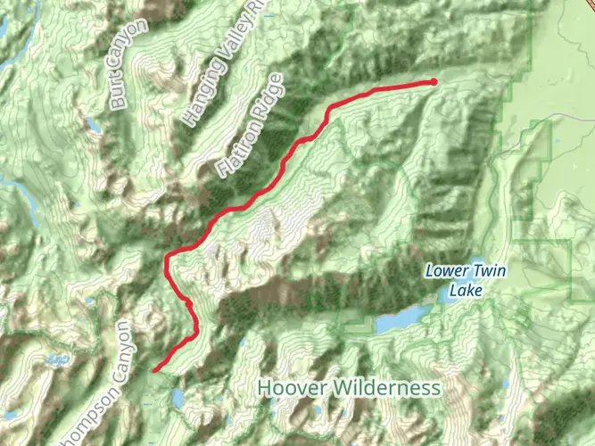
Kerrick Canyon
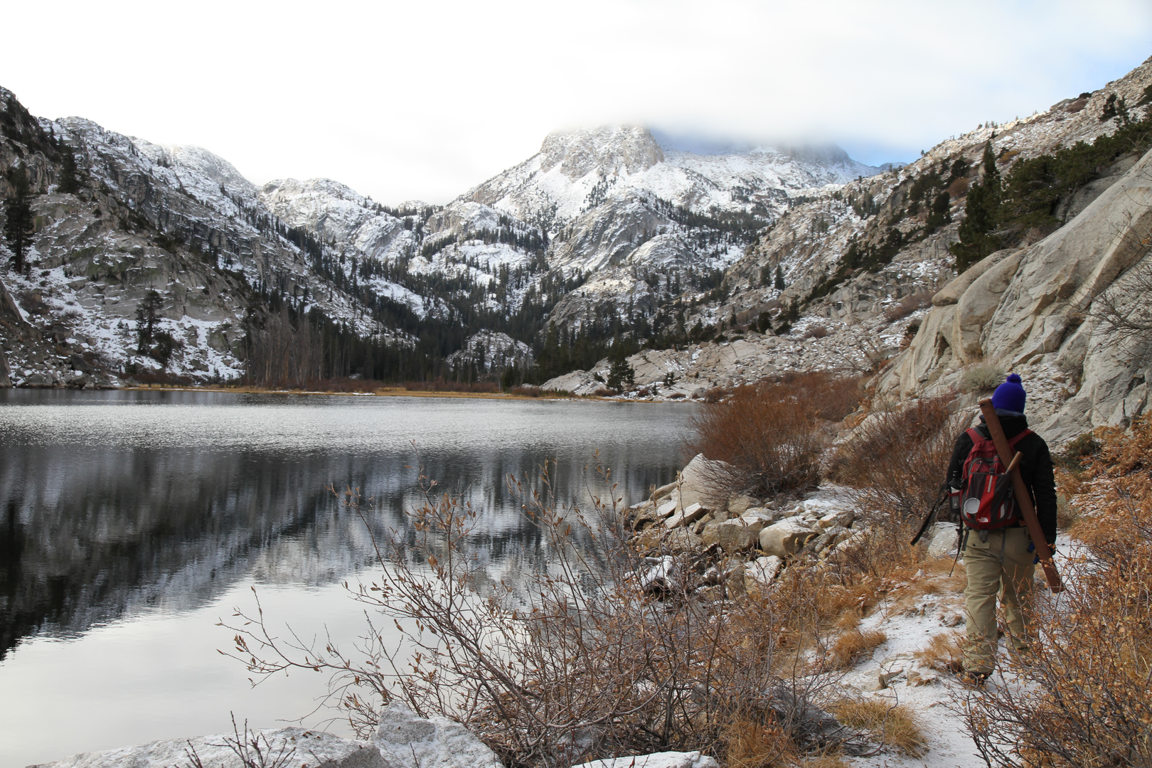
As you progress into Kerrick Canyon, the terrain becomes more rugged, and the views of the surrounding peaks are breathtaking. The canyon itself is a geological marvel, with towering granite walls and a variety of alpine flora. The trail meanders alongside creeks and through meadows, with the sound of water a constant companion.
Matterhorn Canyon
Upon reaching Matterhorn Canyon, named for its resemblance to the famous Swiss peak, the landscape shifts to reveal vast meadows dotted with wildflowers and the occasional glimpse of deer or marmots. The canyon is also home to the impressive Matterhorn Peak, which stands as a sentinel over the area. Hikers will find themselves at the highest elevation of the loop here, with some sections reaching over 3000 meters (nearly 10,000 feet).
Historical Significance
The region is steeped in history, with Native American tribes such as the Miwok and Paiute having traversed these lands for centuries. European explorers and miners later entered the area during the California Gold Rush, and remnants of their passage can sometimes be found along the trail.
Wildlife and Nature
The loop traverses diverse ecosystems, from dense pine forests to subalpine zones. Black bears are common in Yosemite, so proper food storage and bear safety practices are essential. The area is also home to a variety of bird species, including the Clark's nutcracker and the mountain bluebird.
Preparation and Safety
Given the trail's difficulty and remote nature, hikers should be well-prepared with adequate supplies, including water filtration, a first-aid kit, and layers for sudden weather changes. It's also wise to inform someone of your itinerary and expected return time.
Seasonal Considerations
The best time to hike the loop is from late June to early October when the snow has melted, and the trails are more accessible. However, weather in the high Sierra can be unpredictable, and snow can linger in shaded areas or at higher elevations even in summer.
Conclusion
The Kerrick Canyon and Matterhorn Canyon Loop is a demanding but rewarding experience, offering a glimpse into the wild heart of Yosemite's backcountry. With careful planning and respect for the natural environment, hikers will find this trail to be a memorable journey through one of America's most iconic landscapes.

What to expect?
Activity types
Frequently asked questions
How long does the Kerrick Canyon And Matterhorn Canyon Loop usually take to hike?
The Kerrick Canyon And Matterhorn Canyon Loop is about 75.06 km, or roughly 46.6 miles, with 2,551 m of climbing. Most backpackers split a route of that size into about 4 to 6 days, depending on pace, camp locations, and how much time is spent around places like Peeler Lake, Kerrick Canyon, and Matterhorn Canyon.
Where do you start the Kerrick Canyon And Matterhorn Canyon Loop and where can you park?
The usual start for the Kerrick Canyon And Matterhorn Canyon Loop is the Twin Lakes area north of Yosemite, reached from Bridgeport by following Twin Lakes Road to Mono Village at Upper Twin Lake. Parking is commonly used near Mono Village, with the trail access a short walk away from the end of the road.
Do you need a permit for the Kerrick Canyon And Matterhorn Canyon Loop?
Yes. Because the Kerrick Canyon And Matterhorn Canyon Loop is an overnight backcountry trip entering Yosemite wilderness from the Twin Lakes side, a wilderness permit is required for overnight travel. Twin Lakes trailheads are handled outside Yosemite’s main trailhead quota list, with permits issued through the Humboldt-Toiyabe National Forest side for Twin Lakes access.
Are dogs allowed on the Kerrick Canyon And Matterhorn Canyon Loop?
Dogs are not a good fit for the Kerrick Canyon And Matterhorn Canyon Loop. Yosemite does not allow pets on hiking trails or in wilderness areas, and Twin Lakes access is commonly used for trips that continue into Yosemite backcountry, so standard pet access rules become very restrictive once the route enters the park.
How hard is the Kerrick Canyon And Matterhorn Canyon Loop?
The Kerrick Canyon And Matterhorn Canyon Loop is rated Extra Difficult, which matches its scale: 75.06 km with 2,551 m of elevation gain. This is a serious multi-day Sierra backcountry route with long days, sustained climbing, high-elevation travel, and remote sections through Kerrick Canyon and Matterhorn Canyon.
Can the Kerrick Canyon And Matterhorn Canyon Loop be hiked in either direction?
Yes. The Kerrick Canyon And Matterhorn Canyon Loop can be completed clockwise or counterclockwise. A common choice is to head north first toward Peeler Lake from Twin Lakes, which gives a more gradual early climb before the route commits to the longer remote stretches through Kerrick Canyon and Matterhorn Canyon.
What is the best time of year to hike the Kerrick Canyon And Matterhorn Canyon Loop?
The main hiking season for the Kerrick Canyon And Matterhorn Canyon Loop is typically summer into early fall, when Twin Lakes Road and the high country are most reliably snow-free. Because the route sits in Yosemite’s northern high-elevation backcountry near Twin Lakes and Peeler Lake, lingering snow and colder nights can make early season travel much more demanding.
Is there public transportation to the Kerrick Canyon And Matterhorn Canyon Loop trailhead?
Public transportation to the Kerrick Canyon And Matterhorn Canyon Loop trailhead is limited. YARTS serves Mono County seasonally on the Highway 395 and 120 East corridor, but it does not run directly to Mono Village at Twin Lakes, so the final approach from Bridgeport usually requires a private shuttle, taxi, or car.
Comments and Reviews
User comments, reviews and discussions about the Kerrick Canyon And Matterhorn Canyon Loop, California.
4.5
average rating out of 5
6 rating(s)