Download
3D Flyover
Add to list
More
39.0 km
~2 days
699 m
Multi-Day
“Embark on a scenic 39-kilometer trek from forested peaks to the Pacific's waves on the Skyline to Sea Trail.”
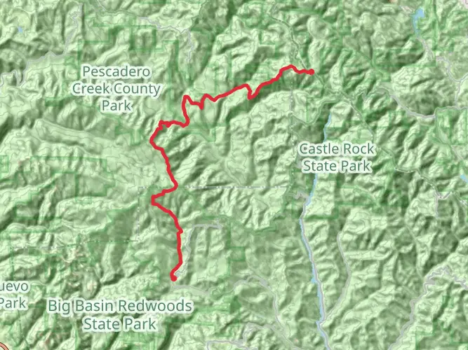
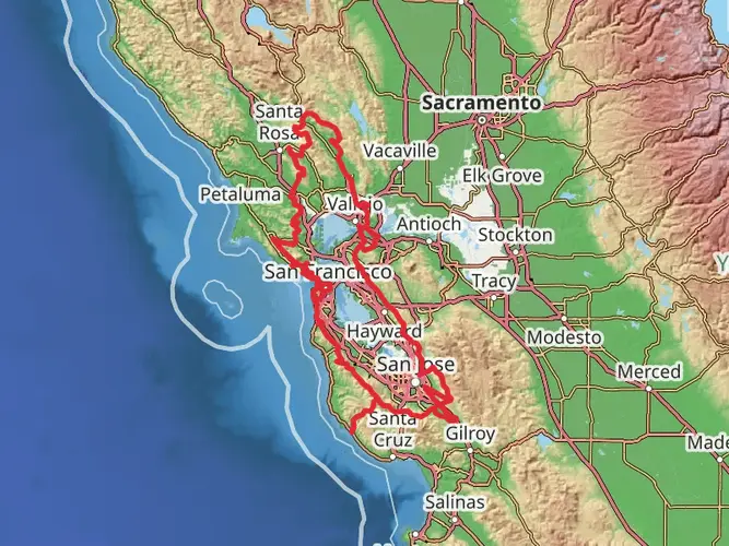
The Skyline to Sea Trail is a captivating journey that spans approximately 39 kilometers (24 miles) and ascends roughly 700 meters (2300 feet) in elevation. This point-to-point trail is nestled in the scenic Santa Cruz Mountains and offers hikers a unique blend of diverse ecosystems, from lush redwood forests to the rugged coastline of the Pacific Ocean.
Getting to the Trailhead
The trailhead is conveniently located near Castle Rock State Park, which is accessible by car. For those opting for public transportation, options are limited, but some local bus services may get you close to the area, from where you might need to arrange a taxi or rideshare to reach the starting point.
Navigating the Trail
Hikers can rely on HiiKER to navigate the trail, ensuring they stay on the correct path and can anticipate upcoming changes in terrain or elevation. The app provides detailed maps and trail information that can be invaluable, especially in areas where cell service might be spotty.
The Journey Through Diverse Landscapes
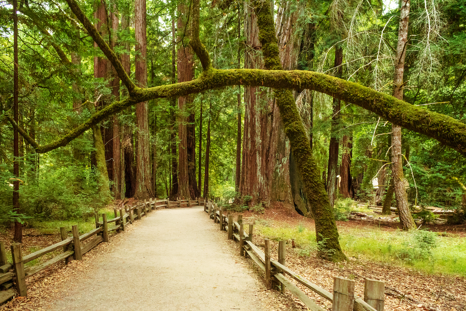
The trail begins amidst towering redwoods, offering a cool, shaded canopy that is a welcome start to the hike. As you progress, the path meanders through Castle Rock State Park, known for its impressive rock formations and viewpoints overlooking the Santa Cruz Mountains.
Continuing the descent, the trail passes through Big Basin Redwoods State Park, California's oldest state park, where you can marvel at ancient redwoods and the park's rich biodiversity. This section is not only a feast for the eyes but also holds historical significance as it showcases the resilience of these forests that have withstood the test of time.
Wildlife and Flora
The Skyline to Sea Trail is a haven for wildlife enthusiasts. Keep an eye out for black-tailed deer, coyotes, and even the elusive mountain lion. Birdwatchers can spot species like the Steller's jay, acorn woodpecker, and the rare marbled murrelet. The trail is also home to a variety of plant life, including the California bay laurel, Douglas fir, and the delicate trillium.
Landmarks and Points of Interest
Approximately halfway through the hike, you'll encounter Berry Creek Falls, a stunning 70-foot waterfall that provides a serene spot to rest and enjoy the sounds of nature. Further along, the trail offers views of the Pacific Ocean, culminating in its final stretch at Waddell Beach, a beautiful and often breezy expanse of coastline.
Preparation and Planning
Given the trail's medium difficulty rating, it's suitable for hikers with some experience. The trail can be completed in 2-3 days, making it an ideal weekend trek. It's important to pack sufficient water, food, and camping supplies if you plan to stay overnight in the designated backcountry campsites. Always check the weather before setting out, as conditions can change rapidly, especially in coastal areas.
Historical Significance
The region through which the Skyline to Sea Trail passes is rich in history. The Ohlone people originally inhabited the area, and evidence of their presence can be seen in the form of shell mounds and artifacts. The logging industry once thrived here, and remnants of old logging operations are still visible along the trail.
Conclusion
By preparing adequately and respecting the natural and historical significance of the area, hikers can ensure a memorable and enjoyable experience on the Skyline to Sea Trail.

What to expect?
Activity types
Frequently asked questions
How long is the Skyline to Sea Trail and how many days does the Skyline to Sea Trail take?
The Skyline to Sea Trail is about 38.96 km, or roughly 24.2 miles, with around 699 m of elevation gain. Most backpackers take 2 to 3 days to complete it, while strong day hikers sometimes cover it in one long push. California State Parks also describes the route as a multi-day backpack from the crest of the Santa Cruz Mountains down to the Pacific coast at Waddell Beach.
Where does the Skyline to Sea Trail start and finish in Santa Cruz County?
The classic Skyline to Sea Trail route starts near Castle Rock State Park along Highway 35 in the Santa Cruz Mountains and heads west through Big Basin Redwoods State Park toward the coast. The traditional finish is at Waddell Beach in the Rancho del Oso area, where the trail meets Highway 1 near the Pacific Ocean.
Is the Skyline to Sea Trail fully open all the way to Waddell Beach right now?
No. California State Parks currently says the Skyline to Sea Trail is open from Castle Rock State Park to the Big Basin day-use area, but the coastal Skyline to the Sea segment near Rancho del Oso is closed 0.4 miles past the Highway 1 entrance because of damage from the 2020 CZU Lightning Complex Fire. That means the full through-hike to Waddell Beach is not currently available as a continuous open route.
Where can you park for the Skyline to Sea Trail at the Castle Rock and Waddell Beach ends?
At the north end, hikers commonly use the main parking lot at Castle Rock State Park on Highway 35, where California State Parks lists a vehicle day-use fee. At the coast, day hikers can park in the lot adjacent to Waddell Beach or along the inland side of Highway 1 near Rancho del Oso. Overnight parking for backpackers is limited to designated trailhead parking lots.
Are dogs allowed on the Skyline to Sea Trail?
Dogs are not a good fit for the Skyline to Sea Trail. Castle Rock State Park prohibits dogs on park trails except for service animals, and Big Basin Redwoods State Park does not allow dogs on the trail system; Rancho del Oso and Waddell State Beach also prohibit dogs. In practice, that means the route is not dog-friendly.
Is the Skyline to Sea Trail hard, and is the Skyline to Sea Trail suitable for beginners?
The route is generally considered easy by long-distance trail standards because it trends downhill from the Skyline ridge toward the coast and has about 699 m, or 2,293 feet, of total elevation gain over nearly 39 km. The bigger challenge is endurance, logistics, and current closures rather than steep technical terrain. It suits fit beginners with solid preparation for a full-day hike or an overnight trip.
What are the main highlights on the Skyline to Sea Trail?
The Skyline to Sea Trail links several of the best-known landscapes in the Santa Cruz Mountains. Highlights include the sandstone scenery and ridge views around Castle Rock State Park, long stretches of redwood forest in Big Basin Redwoods State Park, and the traditional coastal finish near Waddell Marsh and Waddell Beach on the Pacific. The route is especially known for moving from mountain crest to ocean in one continuous westbound journey.
Comments and Reviews
User comments, reviews and discussions about the Skyline to Sea Trail, California.
4.71
average rating out of 5
7 rating(s)