Download
Preview
Add to list
More
33.6 km
~2 days
754 m
Multi-Day
“Trek the Lassen Loop for volcanic wonders, serene lakes, and rich natural tapestry amidst California's peaks.”
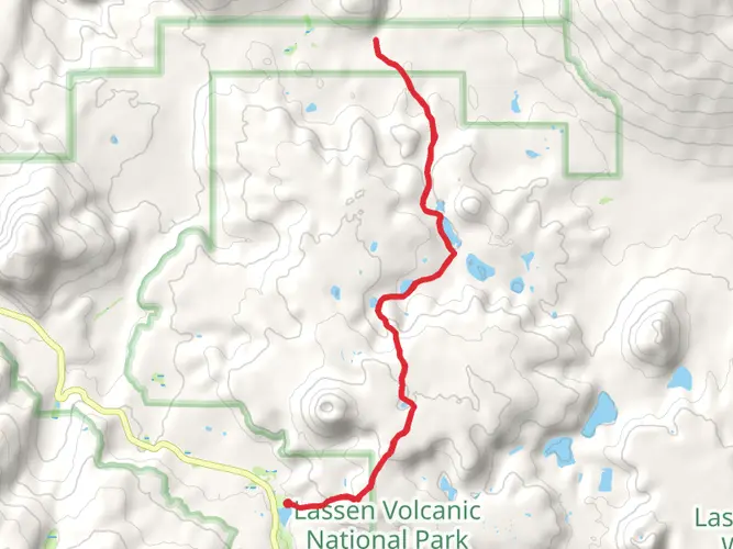
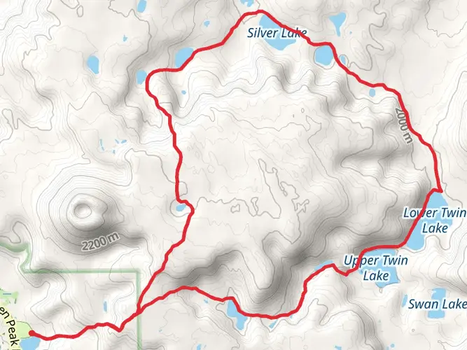
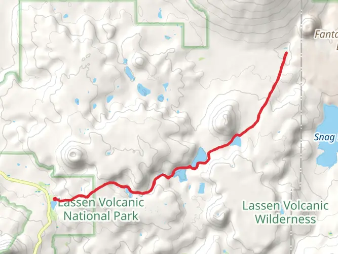
Embarking on the Lassen Volcanic National Park Lakes Loop, hikers will traverse approximately 34 kilometers (about 21 miles) of diverse landscapes, with an elevation gain of around 700 meters (roughly 2300 feet). This loop trail, rated as medium difficulty, offers a comprehensive experience of the park's hydrothermal areas, stunning mountain vistas, and a series of sparkling lakes.
Getting to the Trailhead The trailhead is conveniently located near Shasta County, California. For those driving, the starting point is accessible via Highway 89, which runs through Lassen Volcanic National Park. There is parking available at the trailhead for those arriving by car. Public transportation options are limited, so it's advisable to check the latest schedules and routes if you're planning to arrive without a vehicle.
Navigating the Trail As you set out on the Lakes Loop, it's essential to have a reliable navigation tool. HiiKER is an excellent resource for trail maps and navigation, ensuring you stay on the right path throughout your journey.
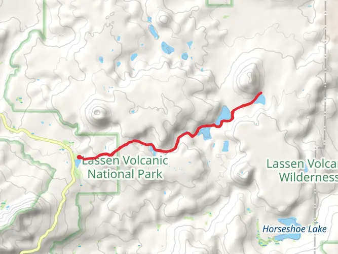
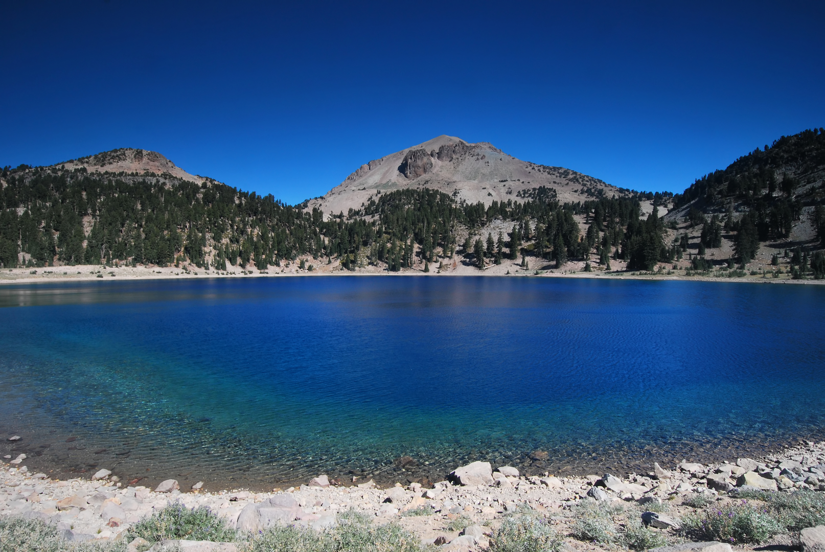
Landmarks and Natural Features The trail offers a variety of natural landmarks that are not to be missed. Early in the hike, you'll encounter the Sulphur Works, a hydrothermal area with bubbling mud pots and steam vents, a testament to the volcanic activity that shaped this landscape. As you continue, you'll be treated to views of the park's largest lake, Lake Helen, known for its striking blue color and the surrounding peaks that reflect off its surface.
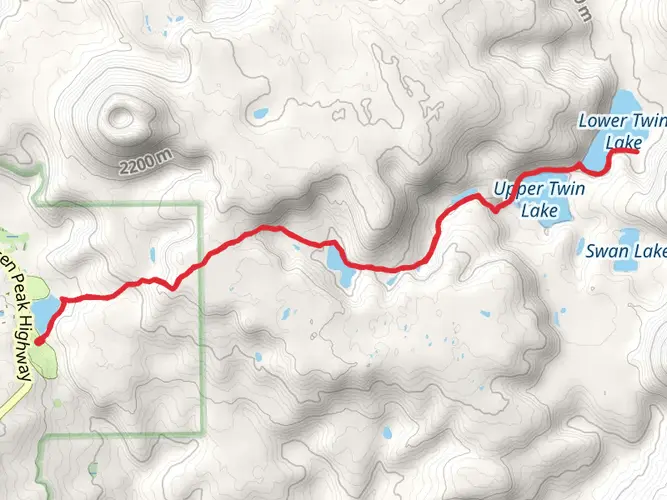
Further along, the trail meanders through lush meadows dotted with wildflowers, especially vibrant during the spring and early summer months. The trail also skirts several other alpine lakes, including Emerald Lake and Reflection Lake, each offering unique and picturesque settings for rest and contemplation.
Wildlife and Flora The park is home to a variety of wildlife, including black bears, mule deer, and a plethora of bird species. Hikers should be aware of their surroundings and knowledgeable about wildlife safety practices. The flora along the trail ranges from mountain hemlock and red fir forests to expansive meadows with wildflowers such as lupines and Indian paintbrush.
Historical Significance Lassen Volcanic National Park is rich in history, with the volcanic activity shaping the region for millions of years. The area was also home to the Native American Atsugewi tribe, and later, it played a role in the early exploration and settlement of Northern California.
Preparation and Planning Before setting out, hikers should be prepared for the trail's medium difficulty rating. It's recommended to carry enough water, as sources along the trail may not be potable, and to pack layers of clothing due to the variable mountain weather. Additionally, checking the park's website for trail conditions and any alerts or closures is crucial for a safe and enjoyable hike.
Remember, the Lassen Volcanic National Park Lakes Loop is a backcountry experience, and it's essential to practice Leave No Trace principles to preserve the park's natural beauty for future generations.

What to expect?
Activity types
Frequently asked questions
How long is the Lassen Volcanic National Park Lakes Loop and how hard is it?
The Lassen Volcanic National Park Lakes Loop is 33.56 km, or about 20.9 miles, with 754 m of elevation gain, roughly 2,474 feet. That puts it in the medium-difficulty range: long enough for a full-day effort for strong hikers, but commonly treated as a backpacking loop because of the mileage and cumulative climbing.
Can you backpack the Lassen Volcanic National Park Lakes Loop overnight?
Yes. The route is well suited to an overnight trip because it is a 33.56 km multi-day loop inside Lassen Volcanic National Park. Overnight backcountry camping in the park requires a wilderness permit, while standard park entry does not require a reservation. Campground reservations and backcountry permits are handled separately.
Are dogs allowed on the Lassen Volcanic National Park Lakes Loop?
No. Pets are not permitted on hiking trails in Lassen Volcanic National Park, and that includes backcountry routes like the Lassen Volcanic National Park Lakes Loop. The park allows leashed pets only in places vehicles can go, such as roads, parking lots, picnic areas, and campgrounds, not on the trail itself or in lakes and streams.
Where do you park for the Lassen Volcanic National Park Lakes Loop?
Access is via Lassen Volcanic National Park Highway, the park road signed as Highway 89. Parking for lake and backcountry hikes is typically at established trailhead lots along the highway, and the Summit Lake area is one of the park’s major trail access points with a large paved parking area. The closest gateway communities are Mineral on the south side and Shingletown on the north side.
Is there public transportation to the Lassen Volcanic National Park Lakes Loop?
No regular public transportation serves Lassen Volcanic National Park, and there is no public transit within the park. Reaching the Lassen Volcanic National Park Lakes Loop generally requires a private vehicle via Highway 89, which is the main road through the park.
What is the best time of year to hike the Lassen Volcanic National Park Lakes Loop?
The best hiking window is usually mid-summer into early fall, when the high country is more likely to be snow-free and Highway 89 is fully open through the park. Lassen’s main park road closes seasonally because of heavy snow, and areas near Lake Helen and the higher trailheads can hold snow well into early summer, so access timing changes from year to year.
What kind of scenery does the Lassen Volcanic National Park Lakes Loop pass?
This loop combines volcanic terrain, hydrothermal features, and a chain of alpine lakes in one route. Landmarks in this part of the park include Sulphur Works, with steam vents and bubbling mud pots, and Lake Helen, one of the park’s best-known high-elevation lakes along the Highway 89 corridor. The route’s 754 m of climbing also opens up broad views across Lassen’s volcanic landscape.
Comments and Reviews
User comments, reviews and discussions about the Lassen Volcanic National Park Lakes Loop, California.
4.0
average rating out of 5
3 rating(s)