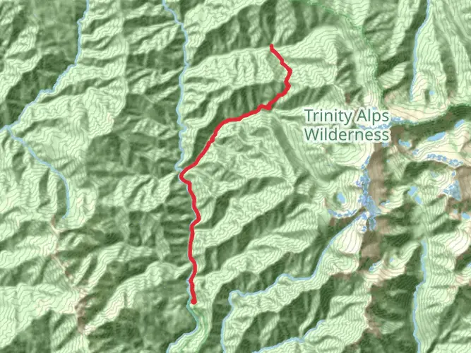
New River and Slide Creek to Historic Mining District and Eagle Creek
Download
3D Flyover
Add to list
More
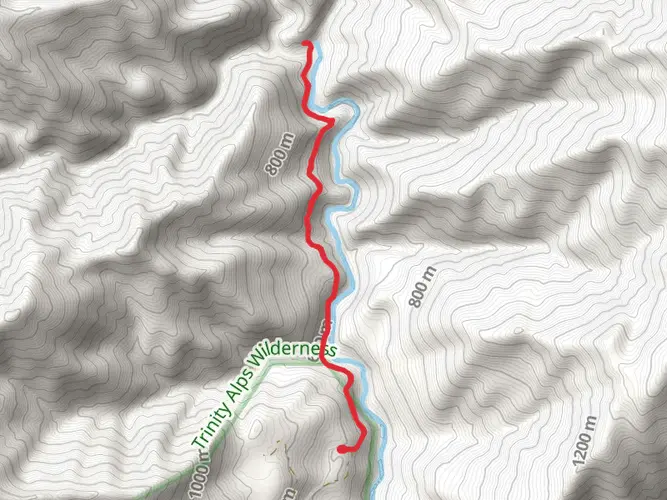
28.2 km
~2 days
1484 m
Multi-Day
“Embark on a historic and rugged 28-kilometer hike through Trinity County's breathtaking and untamed wilderness.”
Embarking on the New River and Slide Creek to Historic Mining District and Eagle Creek trail, hikers will traverse a challenging and rewarding landscape that spans approximately 28 kilometers (about 17.4 miles) with an elevation gain of roughly 1400 meters (about 4593 feet). This point-to-point trail is nestled in the scenic wilderness near Trinity County, California, and is rated as difficult due to its steep inclines and rugged terrain.
Getting to the Trailhead To reach the trailhead, adventurers can drive to the vicinity of Trinity County, where the trail begins. There is no direct public transportation to this remote area, so a personal vehicle is necessary. The closest significant landmark to the trailhead is the small community of Helena, California. From there, hikers can follow the local forest service roads, which may require a high-clearance vehicle, especially after inclement weather.
Navigating the Trail As you set out, the trail meanders along the New River, offering serene views of the water and the dense forest canopy. Hikers should be prepared for multiple river crossings, which can be challenging during high water levels, typically in the spring or after heavy rains. It's advisable to use the HiiKER app to navigate these sections, as the trail can be less defined near the riverbanks.
Historical Significance The trail holds historical significance as it passes through an area that was once bustling with mining activity during the California Gold Rush. As you hike, you'll encounter remnants of the past, including old mining equipment and structures that speak to the region's rich history. The Historic Mining District is a highlight, where you can explore the ruins and imagine the lives of those who sought their fortunes here.
Wildlife and Flora The region is home to a diverse array of wildlife. Keep an eye out for black bears, deer, and various bird species, including eagles along Eagle Creek. The flora is equally impressive, with a mix of coniferous trees, wildflowers, and ferns lining the path. The trail's elevation gain provides different ecological zones, each with its unique plant life.
Landmarks and Scenery As you ascend, the trail offers breathtaking views of the surrounding mountains and valleys. Slide Creek is another notable feature, with its cascading waters providing a picturesque backdrop for a rest or a photo opportunity. Approximately halfway through the hike, you'll reach the highest elevation point, which offers panoramic views and a sense of accomplishment.
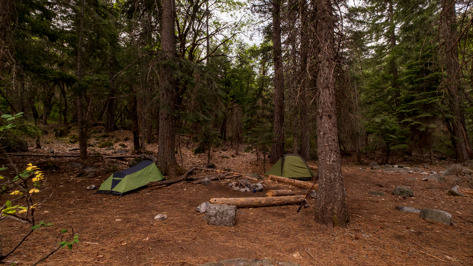
Preparation and Safety Due to the trail's difficulty, it's essential to be well-prepared with adequate supplies, including water, food, and layers for changing weather conditions. Sturdy hiking boots are a must, as the terrain can be rough and uneven. It's also wise to carry a map and compass or a GPS device, with the HiiKER app being a reliable tool for trail navigation and planning.
Seasonal Considerations The best time to hike this trail is from late spring to early fall when the snow has melted, and the river levels are more manageable. However, hikers should always check current trail conditions and weather forecasts before setting out, as the area can experience sudden changes that may affect trail accessibility.
Remember, this trail is not for the faint of heart, but for those who take on its challenge, it promises an unforgettable adventure through a landscape steeped in natural beauty and history.

What to expect?
Activity types
Frequently asked questions
How long is the New River and Slide Creek to Historic Mining District and Eagle Creek hike?
The New River and Slide Creek to Historic Mining District and Eagle Creek route is 28.15 km, or about 17.4 miles. With 1,484 m of elevation gain, it is a difficult multi-day hike rather than a short out-and-back, so most parties should plan for a full backpacking effort instead of a single quick day on trail.
How hard is the New River and Slide Creek to Historic Mining District and Eagle Creek trail?
New River and Slide Creek to Historic Mining District and Eagle Creek is rated difficult, and the numbers explain why: 28.15 km of travel with 1,484 m of climbing. Expect steep grades, rugged tread, and a long day-to-day effort through remote backcountry in Trinity County rather than a casual walk.
Where does the New River and Slide Creek to Historic Mining District and Eagle Creek hike start near Helena, California?
The route is approached from the remote New River backcountry near Helena in Trinity County. Helena is the closest named community, and access is typically via forest roads into the New River drainage; road conditions can be rough enough that high-clearance vehicles are often the safer choice, especially after storms or during wet periods.
Are there river crossings on the New River and Slide Creek to Historic Mining District and Eagle Creek hike?
Yes. This route follows the New River corridor and includes multiple creek or river crossings, especially around New River and Slide Creek. Those crossings can become significantly harder during spring runoff or after heavy rain, so water levels are one of the main conditions that can change the seriousness of the hike.
What historic sites are on the New River and Slide Creek to Historic Mining District and Eagle Creek hike?
The route passes through the New River backcountry, an area known for historic mining districts and old mining-era travel corridors. The New River drainage once linked remote mining centers, so hikers on this route can expect a landscape shaped by California Gold Rush-era activity as the trail heads toward the historic mining district and Eagle Creek.
Is the New River and Slide Creek to Historic Mining District and Eagle Creek hike a day hike or backpacking trip?
This route is best treated as a backpacking trip. At 28.15 km with 1,484 m of ascent and a point-to-point layout in remote Trinity County, New River and Slide Creek to Historic Mining District and Eagle Creek is much more demanding logistically than a standard day hike and usually requires overnight planning.
When is the best time to hike New River and Slide Creek to Historic Mining District and Eagle Creek?
The most practical season is usually the drier part of the year, when creek levels are lower and forest roads are more reliable. Spring can bring stronger flows at crossings, and wet-season conditions can make access roads rough or slow, so late spring through fall is generally the more manageable window for this difficult Trinity County route.
Comments and Reviews
User comments, reviews and discussions about the New River and Slide Creek to Historic Mining District and Eagle Creek, California.
4.75
average rating out of 5
8 rating(s)