Download
Preview
Add to list
More
109.6 km
~6 days
1204 m
Multi-Day
“Explore the quintessentially English landscapes and historical treasures on the scenic Oxfordshire Way trail.”
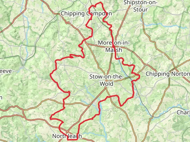
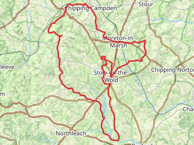
The Oxfordshire Way is a scenic long-distance path that meanders through the picturesque countryside of Oxfordshire, England. Spanning approximately 110 kilometers (about 68 miles) with an elevation gain of around 1200 meters (nearly 3937 feet), this trail offers a medium difficulty level, making it accessible to hikers with a reasonable level of fitness.
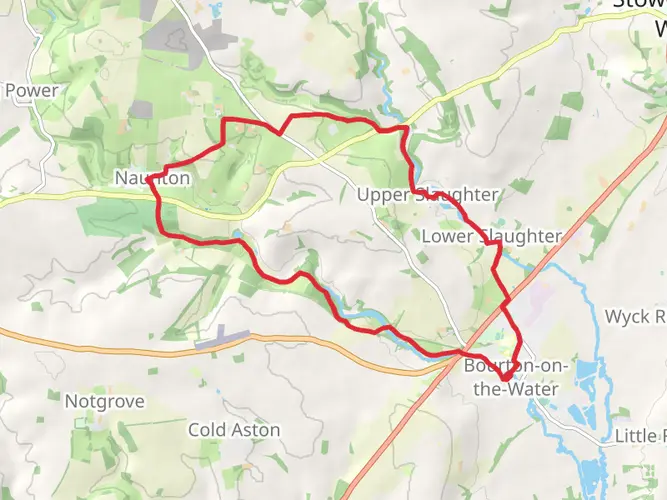
Starting near the village of Bourton-on-the-Water in Gloucestershire, the trail head is easily accessible by car or public transport. For those opting for public transport, regular bus services run to Bourton-on-the-Water from surrounding towns. If driving, parking is available in the village, allowing hikers to leave their vehicles before embarking on the trail.
Navigating the Path
The Oxfordshire Way is well-marked, with distinctive signs guiding hikers along the route. However, it's always wise to carry a reliable navigation tool such as HiiKER, which provides detailed maps and GPS tracking to ensure you stay on the right path.
Landmarks and Scenery
As you set off from the trail head, the path takes you through a landscape dotted with traditional Cotswold stone villages and across rolling hills that offer expansive views of the English countryside. The trail crosses several rivers, including the Thames at Tadpole Bridge, which is a perfect spot for a rest and perhaps a picnic.
One of the significant landmarks along the route is Blenheim Palace, a UNESCO World Heritage Site near Woodstock. This monumental country house is the birthplace of Sir Winston Churchill and is set within over 2000 acres of parkland designed by the famous landscape architect Capability Brown.
Wildlife and Nature
The Oxfordshire Way passes through a variety of habitats, from woodlands to river meadows, which are home to an abundance of wildlife. Keep an eye out for red kites soaring overhead, and in the spring and summer months, the hedgerows and wildflower meadows are alive with the buzz of insects and the songs of birds.
Historical Significance
The region is steeped in history, with the trail often following ancient routes and passing by historic sites. Besides Blenheim Palace, the path also skirts the edge of the Wychwood Forest, once a royal hunting forest, and leads through the historic market town of Henley-on-Thames, known for its annual regatta.
Preparing for the Hike
Before setting out, ensure you have suitable footwear and clothing for the varied terrain and unpredictable English weather. The trail can be completed in sections or as a multi-day hike, with accommodation options ranging from camping to comfortable inns along the route.
Access and Amenities
The Oxfordshire Way is well-served by local amenities, with shops, pubs, and cafes found in the villages along the route. Public transport links, including bus and train services, are available at various points, making it convenient to return to the starting point or travel from the trail's end in Henley-on-Thames.
Whether you're looking for a challenging multi-day adventure or a leisurely day hike, the Oxfordshire Way offers a quintessentially English countryside experience, rich in natural beauty and historical charm.

What to expect?
Activity types
Frequently asked questions
How long is the Oxfordshire Way and how many days does the Oxfordshire Way take to walk?
The Oxfordshire Way is 109.57 km long, or about 68 miles. Most hikers split it into around 5 to 7 days, depending on pace and overnight stops. With 1,204 m of total ascent and generally lowland terrain, it is usually treated as a manageable multi-day trail rather than a strenuous mountain route.
Where does the Oxfordshire Way start and finish?
The Oxfordshire Way runs from Bourton-on-the-Water in Gloucestershire to Henley-on-Thames in Oxfordshire. It crosses the county from the Cotswolds in the northwest to the River Thames in the southeast, finishing in Henley near the river and rail links.
What landmarks and towns does the Oxfordshire Way pass on the way to Henley-on-Thames?
The Oxfordshire Way passes a string of well-known places including Bledington, Charlbury, Woodstock, Kirtlington, Tiddington, Watlington, Middle Assendon, and Lower Assendon before reaching Henley-on-Thames. Notable highlights on or near the route include Blenheim Palace near Woodstock and the crossing of the River Thames at Tadpole Bridge.
Is the Oxfordshire Way difficult, and is the Oxfordshire Way suitable for beginners?
The Oxfordshire Way is generally considered an easy long-distance walk. Over 109.57 km it gains 1,204 m of elevation, so the challenge comes more from the distance and the number of days required than from steep climbing. It suits beginners with decent walking fitness and some experience of full-day hikes.
Can the Oxfordshire Way be reached by public transport at both ends?
Yes. The Oxfordshire Way starts in Bourton-on-the-Water, which has bus connections to surrounding towns, and finishes in Henley-on-Thames, which has a railway station. Other places on or near the route with public transport links include Woodstock, Kirtlington, Tiddington, and Watlington, making section hiking practical as well as end-to-end trips.
What is the terrain like on the Oxfordshire Way?
The Oxfordshire Way is a lowland route through rolling countryside rather than a rugged upland trail. It links Cotswold landscapes with the Chilterns and passes through farmland, villages, woodland sections, and river country, with steady undulations instead of sustained steep ascents.
Comments and Reviews
User comments, reviews and discussions about the Oxfordshire Way, England.
4.57
average rating out of 5
7 rating(s)