Download
Preview
Add to list
More
121.3 km
~7 days
2452 m
Multi-Day
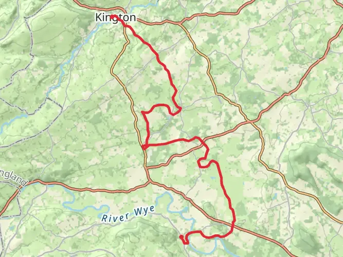
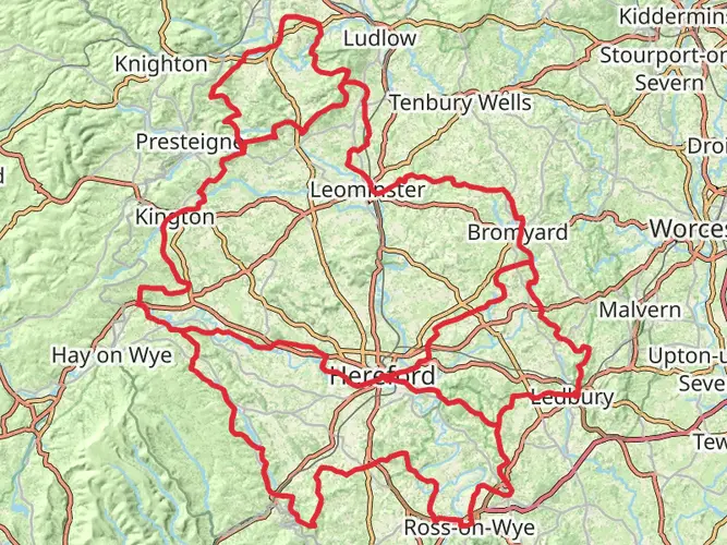
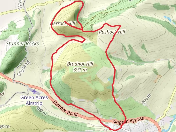
The Wyche Way is a 121.3 km trail that starts in , Herefordshire, England. Based on our data, the hike is graded as Medium. For information on how we grade trails, please read measuring the difficulty of a hiking trail on hiiker. Also, check our latest community posts for trail updates. This hike can be completed in approx 5 days. Caution is advised on trail times as this depends on multiple variables. For more info read about how we calculate hike time.

What to expect?
Activity types
Frequently asked questions
How long does it take to hike the Wyche Way in Herefordshire?
The Wyche Way is a 121.3 km multi-day route with 2,452 m of climbing, so most hikers split it over about 5 to 7 days depending on pace and overnight stops. Strong walkers may move faster, but the distance and cumulative ascent make it more than a casual weekend walk.
Is the Wyche Way a difficult walk or is the Wyche Way suitable for intermediate hikers?
The Wyche Way is generally a medium-difficulty long-distance walk. At 121.3 km with 2,452 m of elevation gain, it suits hikers who are comfortable with full-day stages, repeated climbs, and several consecutive days on foot rather than complete beginners.
Where does the Wyche Way start and finish, and can the Wyche Way be walked from Ledbury?
The Wyche Way is in Herefordshire and is commonly associated with the eastern side of the county near the Malvern area, so Ledbury is one of the most practical access towns for setting up a walk. Ledbury has a National Rail station on The Homend with 38 parking spaces at the station, making it a realistic place to begin or organize transport for the route.
Can you reach the Wyche Way by public transport from Ledbury or Colwall?
Yes. Ledbury is the strongest rail access point because Ledbury station is served by National Rail and has station parking, while Colwall also has rail access nearby but more limited facilities, including no cycle parking listed by Herefordshire Council. Bus links around the Malvern and Colwall side of the route also serve places such as Upper Wyche.
Are there stiles on the Wyche Way, and is the Wyche Way accessible for less mobile walkers?
The Wyche Way should be treated as a traditional countryside long-distance trail rather than an accessible route. Herefordshire Council notes that stiles remain a common obstacle on the county rights-of-way network, and its fully accessible or easier-access walks are listed separately, which suggests the Wyche Way is likely to include gates, uneven ground, and possible stiles.
What kind of scenery does the Wyche Way pass through in Herefordshire?
The Wyche Way covers a substantial stretch of Herefordshire and combines ridge walking with lower farmland and valley sections. In this part of the county, long-distance routes are known for hill country, river valleys, historic landscapes, and views toward the Malvern Hills, so the walk mixes open viewpoints with quieter rural sections.
Comments and Reviews
User comments, reviews and discussions about the Wyche Way, England.
average rating out of 5
0 rating(s)