Download
Preview
Add to list
More
256.7 km
~13 days
2067 m
Multi-Day
“Embark on a scenic and historic 257-km trek through Hertfordshire's diverse landscapes and rich heritage.”
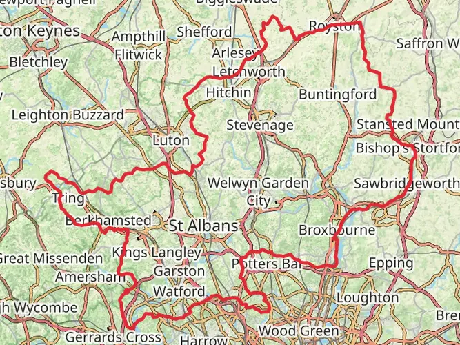
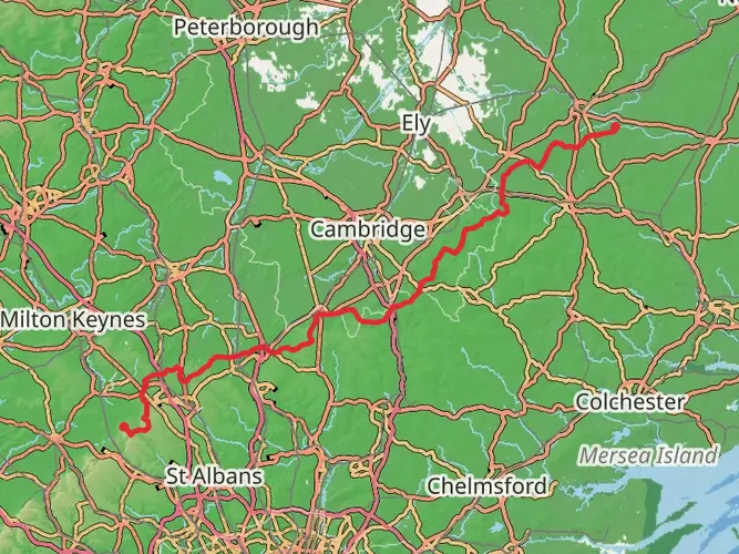
The Hertfordshire Way is a captivating loop trail that spans approximately 257 kilometers (160 miles) with an elevation gain of around 2000 meters (6562 feet), offering a medium difficulty rating that caters to both seasoned hikers and those looking to immerse themselves in the English countryside. This trail encircles the county of Hertfordshire, England, showcasing the region's rich tapestry of landscapes, wildlife, and historical landmarks.
Getting to the Trailhead
The trailhead is conveniently located near Hertfordshire, with several access points due to the looped nature of the trail. For those opting for public transport, the county is well-served by trains and buses, allowing hikers to choose their starting point based on convenience. If traveling by car, there are numerous parking options near the various entry points around the county.
Navigating the Trail
Hikers can rely on the HiiKER app for detailed maps and navigation assistance throughout their journey on the Hertfordshire Way. The trail is well-marked with distinctive yellow and white signs featuring an oak leaf, the symbol of the Hertfordshire Way.
Landmarks and Historical Significance
As you traverse the Hertfordshire Way, you'll encounter a variety of landmarks that speak to the region's historical significance. The trail passes through ancient market towns like Bishop's Stortford and Hitchin, where hikers can explore centuries-old streets and architecture. The path also winds near the Roman town of Verulamium, present-day St Albans, where the ruins of Roman walls and an amphitheater whisper tales of the past.
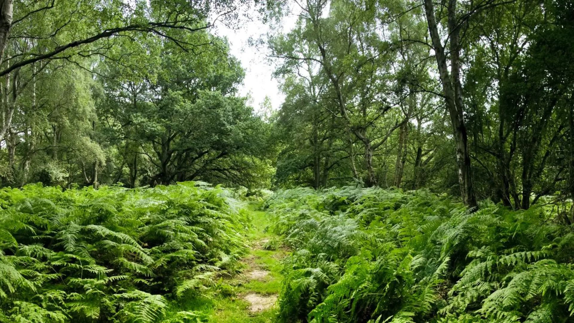
Natural Beauty and Wildlife
The Hertfordshire Way offers a diverse range of scenery, from rolling chalk hills and woodlands to serene river valleys and picturesque farmland. The trail crosses several nature reserves, such as the Panshanger Park, which is a haven for birdwatchers with its variety of species, including kingfishers and herons. The changing seasons bring different delights, from bluebell-carpeted woodlands in spring to the golden hues of harvest fields in autumn.
Trail Sections and Elevation
The trail can be broken down into manageable sections, with each offering its own unique experience. For example, the stretch from Royston to Baldock covers about 19 kilometers (12 miles) and includes a gentle ascent through the Therfield Heath, known for its vibrant display of wildflowers and butterflies. Another notable section is the ascent to the Pegsdon Hills, which provides panoramic views of the surrounding countryside.
Preparation and Planning
Before embarking on the Hertfordshire Way, hikers should prepare for the English weather, which can be unpredictable. Waterproof gear and layered clothing are essential. It's also advisable to carry a water bottle, snacks, and a first-aid kit. While there are plenty of opportunities to restock supplies in the towns along the route, it's important to plan ahead, especially for the more remote sections of the trail.
Conclusion
The Hertfordshire Way is a journey through the heart of English heritage and natural beauty. Whether you're looking to delve into the history of Hertfordshire or simply enjoy a long-distance walk through varied landscapes, this trail offers an enriching experience for all who tread its path.

What to expect?
Activity types
Frequently asked questions
How long does it take to walk the Hertfordshire Way?
The Hertfordshire Way is 256.74 km, or about 160 miles, so most walkers treat it as a multi-day route. A common schedule is around 10 to 16 days, depending on daily mileage, with the route traditionally divided into 16 legs that range from roughly 17 km to 24 km.
Is the Hertfordshire Way a circular walk and can the Hertfordshire Way be started anywhere?
The Hertfordshire Way is a circular long-distance trail around Hertfordshire, so there is no single mandatory start point. It can be joined at many places around the county, and the route is commonly described as waymarked in an anticlockwise direction with yellow-and-white markers featuring an oak leaf.
How hard is the Hertfordshire Way and is the Hertfordshire Way suitable for beginners?
The Hertfordshire Way is generally considered an easy long-distance walk, with 2,067 m of total elevation gain spread across 256.74 km. That makes it much less mountainous than many UK national trails, but the full route is still a serious endurance walk because of its overall distance and the number of consecutive days involved.
Which towns does the Hertfordshire Way pass through or near?
The Hertfordshire Way links a wide spread of Hertfordshire countryside and passes through or near places including Hertford, St Albans, Bishop's Stortford, Hitchin, and Tring. Those towns make practical staging points for food, lodging, and transport while also giving the route a mix of rural paths, historic streets, and village sections.
Is the Hertfordshire Way well waymarked?
The Hertfordshire Way is known for being well waymarked, using distinctive yellow-and-white signs with an oak leaf symbol. Even so, on a 256.74 km county circuit there can be road crossings, field-edge paths, and urban links, so navigation is easier with a detailed map or offline route guidance.
Can the Hertfordshire Way be reached by public transport?
Yes. One of the practical advantages of the Hertfordshire Way is that many sections can be reached by rail or bus, and several of the traditional stage points are accessible from stations in towns such as Hertford, St Albans, Bishop's Stortford, Hitchin, and Tring. Because it is a loop, public transport also makes it easy to walk individual legs without returning to a fixed trailhead.
Comments and Reviews
User comments, reviews and discussions about the Hertfordshire Way, England.
4.8
average rating out of 5
5 rating(s)