Download
Preview
Add to list
More
44.5 km
~3 days
563 m
Multi-Day
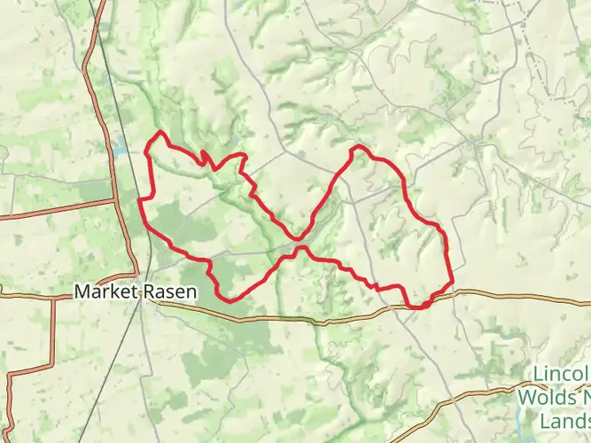
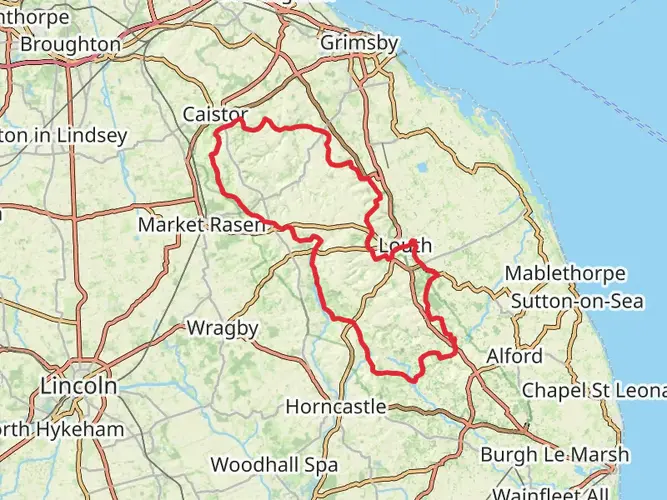
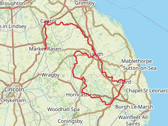
The Caistor Loop via the Viking Way is a 44.5 km trail that starts in West Lindsey, Lincolnshire, England. Based on our data, the hike is graded as Easy. For information on how we grade trails, please read measuring the difficulty of a hiking trail on hiiker. Also, check our latest community posts for trail updates. This hike can be completed in approx 2 days. Caution is advised on trail times as this depends on multiple variables. For more info read about how we calculate hike time.

What to expect?
Activity types
Frequently asked questions
How long is the Caistor Loop via the Viking Way and how many days does it take?
The Caistor Loop via the Viking Way is 44.46 km long with 563 m of climbing. It is set up as a multi-day route, and the staged version is commonly split into three days of about 15.4 km, 14.8 km, and 14.3 km, making it manageable for a relaxed weekend itinerary.
Is the Caistor Loop via the Viking Way difficult?
The Caistor Loop via the Viking Way is graded easy, but it is still a 44.46 km multi-day walk with 563 m of elevation gain. The route is better described as straightforward over distance rather than steep or technical, so the main challenge is covering the mileage across the Lincolnshire countryside.
Where does the Caistor Loop via the Viking Way start and finish?
The Caistor Loop via the Viking Way starts and finishes in Caistor in West Lindsey, with the staged route shown from and back to Caistor Methodist Church, LN7 6UF. That makes Caistor the practical base for arrival, parking, and overnight logistics before or after the walk.
Can the Caistor Loop via the Viking Way be walked in stages?
Yes. The Caistor Loop via the Viking Way is commonly divided into three stages: about 15.4 km from Caistor to Walesby Woodlands Caravan Park, 14.8 km onward to the LN8 3GW area, and 14.3 km back to Caistor. That breakdown suits hikers who want shorter daily distances instead of covering all 44.46 km at once.
Is the Caistor Loop via the Viking Way dog friendly?
The Viking Way around Caistor is promoted locally as dog friendly, so the Caistor Loop via the Viking Way is generally suitable for hikers with dogs. As with many Lincolnshire rights of way, sections can pass through farmland and near livestock, so leads may be needed on parts of the route.
What is the terrain like on the Caistor Loop via the Viking Way?
The Caistor Loop via the Viking Way follows the Lincolnshire Wolds area and uses sections of the Viking Way, so the terrain is typically rolling rather than mountainous. With 563 m of total ascent over 44.46 km, the route is more about steady undulation, field paths, tracks, and rural footpaths than sustained steep climbing.
Is there public transport for the Caistor Loop via the Viking Way?
Yes. Caistor is served by bus services, including stops at Caistor Butter Market, which gives the Caistor Loop via the Viking Way a workable public transport start and finish. Because the route is circular and returns to Caistor, it is easier to plan than a point-to-point walk.
Comments and Reviews
User comments, reviews and discussions about the Caistor Loop via the Viking Way, England.
4.0
average rating out of 5
1 rating(s)