Download
Preview
Add to list
More
31.8 km
~2 days
265 m
Multi-Day
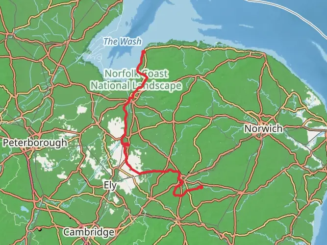
The Little Ouse Path is a 31.8 km trail that starts in Breckland, Norfolk, England. Based on our data, the hike is graded as Easy. For information on how we grade trails, please read measuring the difficulty of a hiking trail on hiiker. Also, check our latest community posts for trail updates. This hike can be completed in approx 6 hrs 48 mins. Caution is advised on trail times as this depends on multiple variables. For more info read about how we calculate hike time.

What to expect?
Activity types
Frequently asked questions
How long is the Little Ouse Path and how many days does the Little Ouse Path take?
The Little Ouse Path is 31.76 km long with 265 m of elevation gain, so it is a relatively gentle multi-day route. A typical completion time is about 2 days, although stronger walkers can cover the distance faster on this easy-grade trail between Thetford and Brandon.
Where does the Little Ouse Path start and finish in Norfolk?
The Little Ouse Path follows the River Little Ouse between Thetford and Brandon. Norfolk County Council describes it as a route from the center of Thetford to Brandon, tracing the river through the Brecks landscape with a mix of town-edge paths, reedbeds, heathland, and forest.
Is the Little Ouse Path easy or suitable for beginner hikers?
The Little Ouse Path is graded Easy, with 31.76 km of distance spread over a multi-day route and only 265 m of total ascent. That makes it a good option for beginners who are comfortable with longer mileage and want a low-gradient walk rather than a steep hill route.
Can the Little Ouse Path be done as a day hike instead of a multi-day walk?
Yes. Although the Little Ouse Path is listed as a multi-day trail, the full 31.76 km distance and modest 265 m elevation gain mean experienced walkers may complete it in a long single day. Many hikers still split it over 2 days to keep the pace relaxed and allow more time along the river corridor.
Is there public transport for the Little Ouse Path between Thetford and Brandon?
Yes. Norfolk County Council notes that the Little Ouse Path is served by both rail and bus links between Thetford and Brandon, which makes the linear route practical without a car. That is especially useful for one-way walks, since the path runs between the two towns rather than forming a loop.
Is parking available for the Little Ouse Path trailheads?
Yes. The Little Ouse Path is accessible for drivers as well as non-drivers, and Norfolk County Council notes that there is plenty of parking available for the route. The main access points are in Thetford and Brandon, the two towns linked by the path along the Little Ouse River.
What kind of scenery does the Little Ouse Path pass through?
The Little Ouse Path follows the gentle meanders of the Little Ouse River through the Brecks, linking Thetford and Brandon. Along the way it passes riverside sections, reedbeds, heathland, and forest, giving the route a varied landscape despite its easy profile and relatively low total ascent.
Are there any hazards or seasonal issues on the Little Ouse Path?
The main caution on the Little Ouse Path is flooding. Norfolk County Council advises extra care on the riverside towpath between Thetford and Brandon because this stretch lies in a flood-risk area, so conditions can be wetter or more difficult after heavy rain or during periods of high water.
Comments and Reviews
User comments, reviews and discussions about the Little Ouse Path, England.
5.0
average rating out of 5
1 rating(s)