Download
Preview
Add to list
More
251.0 km
~13 days
1898 m
Multi-Day
“Embark on a captivating 251-kilometer odyssey along England's Northeast coast, brimming with historic landmarks, diverse wildlife, and awe-inspiring vistas.”
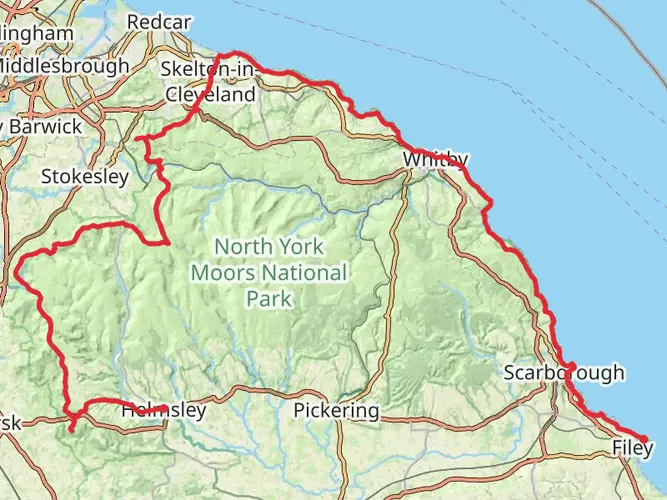
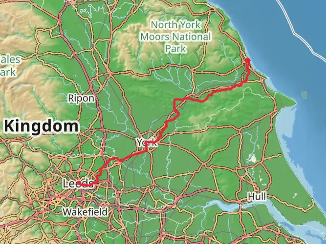
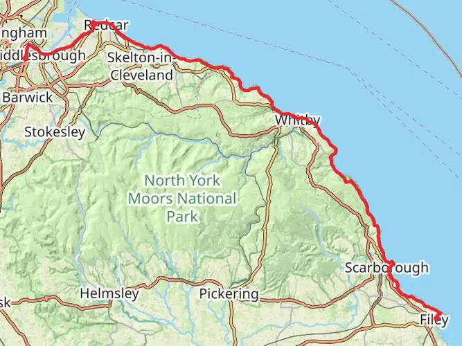
Spanning approximately 251 kilometers (about 156 miles) with an elevation gain of around 1800 meters (roughly 5905 feet), the England Coast Path in the Northeast stretches from the starting point near North Yorkshire, England, and offers a medium difficulty level for hikers. This point-to-point trail is a part of the England Coast Path National Trail, which is an ambitious project aiming to create a continuous walking route around the entire coast of England.
Getting to the Trailhead
The trailhead, located near North Yorkshire, is accessible by both public transport and car. For those opting for public transport, there are train services to nearby towns such as Scarborough or Whitby, from where local buses can take you closer to the starting point. If driving, you can navigate to the nearest significant landmark or address to the trailhead and find parking facilities before beginning your hike.
Navigating the Trail
As you embark on this coastal journey, you'll find that the trail is well-marked, but carrying a reliable navigation tool like HiiKER is advisable to stay on track and be aware of upcoming waypoints. The path meanders along rugged cliffs, sandy beaches, and rolling hills, offering a diverse walking experience.
Landmarks and Historical Significance
The trail is rich in historical significance, passing through ancient fishing villages and near historic castles, such as the dramatic ruins of Whitby Abbey, which dates back to the 7th century. The Abbey is approximately 35 kilometers (22 miles) from the start and is perched atop a cliff, providing spectacular views of the surrounding area.
As you continue, you'll encounter the Bempton Cliffs around 100 kilometers (62 miles) into your hike. This RSPB nature reserve is home to the UK's largest seabird colony, including puffins and gannets, especially during the breeding season from March to October.
Nature and Wildlife
The trail offers an opportunity to immerse yourself in the natural beauty of the English coastline. Expect to see a variety of wildlife, including seabirds, seals, and possibly even dolphins or whales off the coast. The flora along the path is equally diverse, with coastal heathlands and wildflowers in the spring and summer months.
Terrain and Conditions
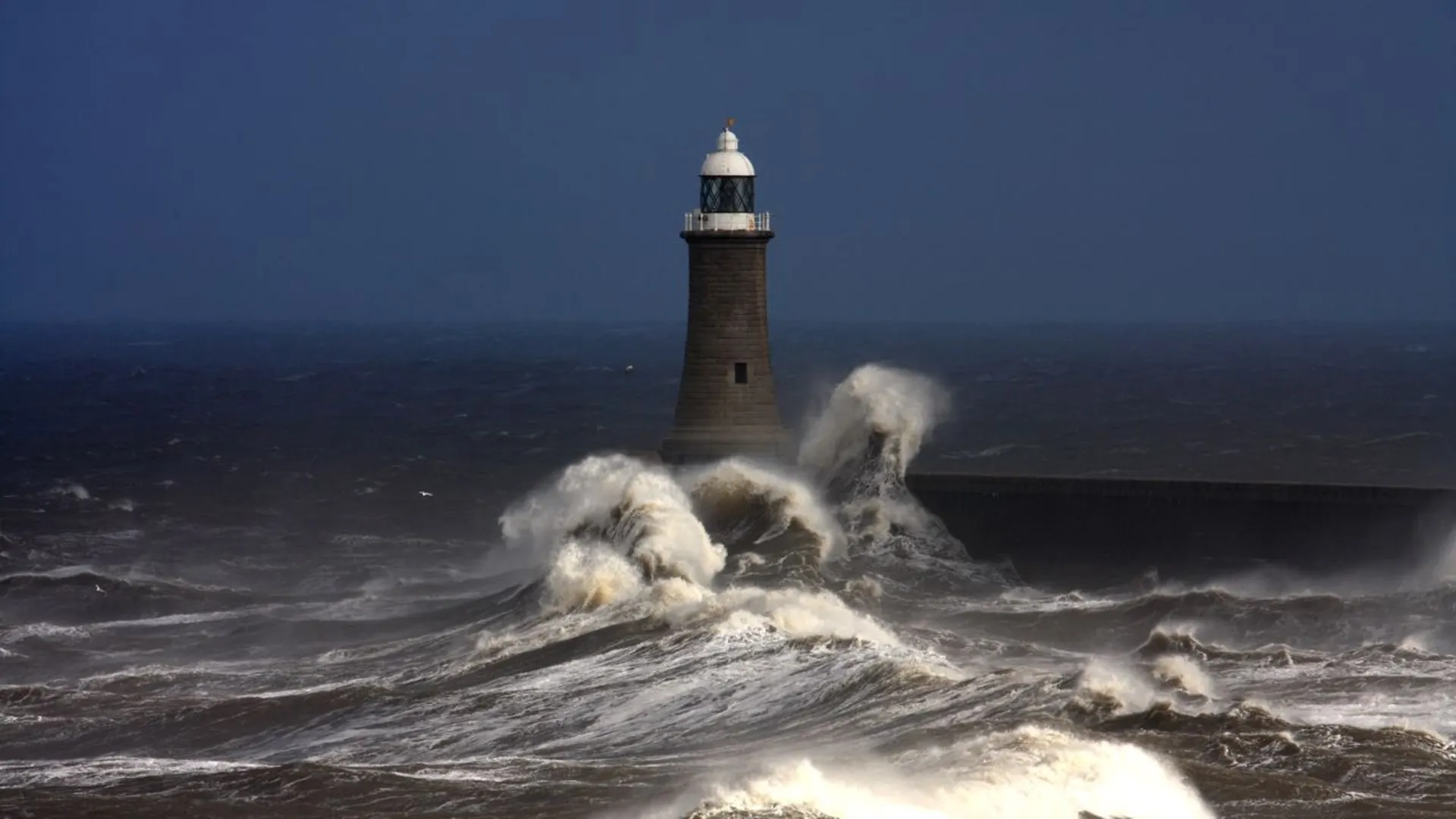
The terrain varies from flat, easy sections to more challenging, steep climbs, particularly as you navigate the cliff-top paths. Weather conditions can change rapidly, so it's essential to be prepared with appropriate clothing and gear. The trail can be muddy and slippery in places, especially after rain, so sturdy waterproof boots are recommended.
Planning Your Hike
Given the length of the trail, planning is crucial. There are several towns and villages along the route where you can restock supplies, find accommodation, or enjoy local cuisine. It's advisable to book accommodations in advance, especially during peak seasons.
Remember to respect the environment and follow the Leave No Trace principles to preserve the beauty of the coastline for future hikers. Always check the tide times for sections that may be impassable at high tide and be aware of any local restrictions or conservation efforts in place to protect the delicate ecosystems you'll be exploring.

What to expect?
Activity types
Frequently asked questions
How long does it take to hike the England Coast Paths - Northeast route?
England Coast Paths - Northeast is 250.99 km long with 1,898 m of climbing, so most walkers treat it as a multi-day point-to-point hike. A typical pace is around 7 to 12 days depending on daily mileage, weather, and how much time is spent in places such as Scarborough, Whitby, Saltburn-by-the-Sea, and Redcar along the coast.
Where does the England Coast Paths - Northeast route go in North Yorkshire?
This stretch follows the North Yorkshire and Teesside coast, linking major seaside towns and headlands on the northeast coast. National Trails describes it as running through places including Middlesbrough, Redcar, Saltburn-by-the-Sea, Whitby, Scarborough, and Filey, with sea cliffs, beaches, and urban waterfront sections along the way.
Is the England Coast Paths - Northeast route hard?
England Coast Paths - Northeast is generally a medium-difficulty long-distance walk rather than an extreme mountain trail. The challenge comes from its 250.99 km length, repeated cliff and headland undulations, and 1,898 m of total ascent, especially on the more rugged coastal sections around the North Yorkshire cliffs and bays.
Can dogs go on the England Coast Paths - Northeast trail?
Dogs are generally allowed on the England Coast Paths - Northeast because coastal access rights in England permit dog walking on the trail and coastal margin. Dogs must be kept under effective control, and on a short lead near livestock; local restrictions or signed exclusions can still apply on specific sections, beaches, or sensitive wildlife areas.
What are the main highlights on the England Coast Paths - Northeast walk?
Major highlights on England Coast Paths - Northeast include the cliff scenery of the North Yorkshire coast, the harbor towns of Whitby and Scarborough, and the Victorian seafront at Saltburn-by-the-Sea. National Trails also notes that this coast passes dramatic sea-view sections and well-known heritage spots, with Whitby Abbey standing out as one of the best-known landmarks near the route.
Can the England Coast Paths - Northeast route be reached by public transport?
Yes. The route passes through several towns with rail or bus connections, making it practical to join or leave in stages rather than hiking all 250.99 km at once. Scarborough and Middlesbrough are key rail hubs for this coast, Whitby is served by local bus links, and North Yorkshire Council also operates a 450-space park-and-ride site at Whitby on the A171/B1460 junction.
Comments and Reviews
User comments, reviews and discussions about the England Coast Paths - Northeast, England.
4.8
average rating out of 5
5 rating(s)