Download
3D Flyover
Add to list
More
187.8 km
~8 days
3834 m
Multi-Day
“A richly changing crossing from wild moors to abbey ruins by the sea, rewarding prepared walkers.”
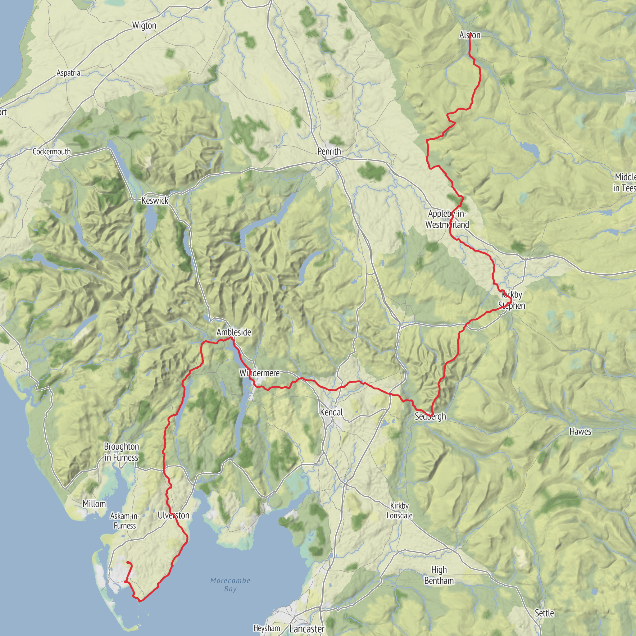
This is a varied long-distance walk through some of northern England’s most distinctive landscapes, linking the North Pennines, Eden Valley, Yorkshire Dales fringe, the Lake District, the Furness fells and finally the coast at Morecambe Bay. The full route is about 193 km / 120 miles, though your estimate of around 187 km / 116 miles is close enough for planning purposes depending on mapping source and any small diversions. Total ascent is commonly given at roughly 3,800 m / 12,470 ft, which fits a solid medium-grade end-to-end trek: long enough to demand stamina, but generally less severe than a sustained high mountain route. (furnessway.co.uk)
The route runs from Alston, Cumbria, England’s highest market town, to Furness Abbey, Manor Road, Barrow-in-Furness, Cumbria LA13 0PJ area, near Barrow-in-Furness. If your hike-head field is blank, the nearest clear start landmark is Alston town centre / Market Cross area, Alston, Cumbria CA9, and the finish is the major historic landmark of Furness Abbey, just outside central Barrow. The trail can be walked in either direction, but north-to-south gives a particularly strong sense of progression: wild uplands first, then softer pastoral country, then lakes and woodland, and finally the red sandstone abbey ruins near the sea. (furnessway.co.uk)
For most hikers, this is best planned as an 8- to 14-day journey, with official stage suggestions ranging from 16 to 27 miles / 25 to 43 km. The six main sections are Alston to Milburn, Milburn to Kirkby Stephen, Kirkby Stephen to Sedbergh, Sedbergh to Bowness-on-Windermere, Bowness to Ulverston, and Ulverston to Furness Abbey. Each stage end is intended to be reachable by public transport, which makes section hiking realistic if you do not want to commit to the full crossing. (furnessway.co.uk)
What the walk feels like
The character changes dramatically as you go. The opening Pennine section is the most exposed and serious underfoot, with wet ground, high moorland and a remote feel. The middle sections through the Eden Valley and Dales are gentler in gradient but still long, with a mix of riverside paths, farmland, old tracks and open fell-edge walking. The Lake District and Furness sections bring more wooded trails, steeper short climbs, and more frequent settlements, while the final coastal stretch is lower, easier going, and rich in birdlife and historical interest. Overall, “medium” is a fair rating, but that hides the fact that some days are much tougher than others. Stage 1 and the higher options in Stage 3 are notably harder than the coastal finish. (furnessway.co.uk)
Expect a mixture of field paths, riverside trails, old drove roads, moorland tracks, woodland paths, short road links and coastal paths. In wet weather, the Pennine ground can become boggy and slow, and some farmland sections can also be muddy. The route is still being developed toward its official opening in autumn 2026, so waymarking and path furniture may vary, and temporary diversions are possible. For navigation, use HiiKER with offline mapping and check for route updates before setting out. (furnessway.co.uk)
Section-by-section expectations
Alston to Milburn is roughly 16 miles / 25
Comments and Reviews
User comments, reviews and discussions about the Westmoreland and Furness Way, England.
average rating out of 5
0 rating(s)
