Download
3D Flyover
Add to list
More
6.3 km
~2 hrs 10 min
548 m
Out and Back
“A steep limestone balcony above Lake Annecy, where airy ridgelines reward confident hikers with sweeping vistas.”
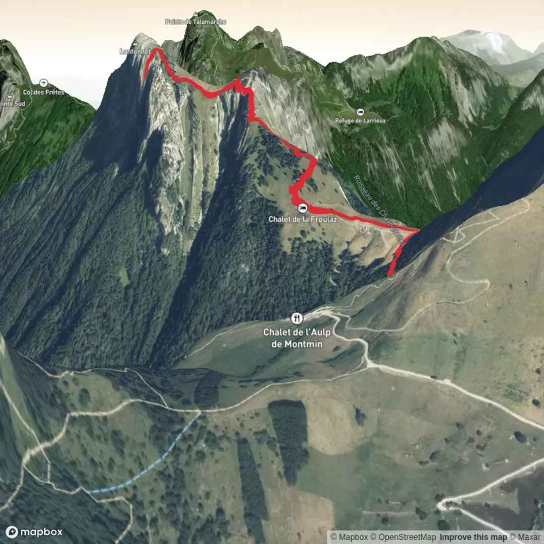
This is a short, steep mountain outing above Lake Annecy that packs a lot into ~6 km / ~3.7 mi: sustained climbing (about 600 m / ~1,970 ft), airy limestone terrain near the top, and big “balcony” views over the lake and the surrounding massifs. The high point is Roche Murraz (often described as the summit of Le Lanfonnet) around 1,768 m / 5,801 ft, set between the Dents de Lanfon and La Tournette in the Bornes Massif. (outtrip.fr)
Getting to the start (car + public transport)
Because your hike-head field is blank, the most common, practical start for a ~6 km / ~600 m day is the Montmin / “Prés Ronds” parking area above Talloires-Montmin (the usual access for Lanfonnet/Roche Murraz via Chalet de l’Aulp and Col des Nantets). If you’re building the route in HiiKER, look for trailheads around Montmin and Chalet de l’Aulp de Montmin—that cluster is the standard jumping-off point for this summit. (mef74.fr)
- By car: Drive to the Montmin side above Talloires-Montmin and follow signs toward the Chalet de l’Aulp / Prés Ronds parking. In peak season, arrive early—this is a popular access for several big hikes (including routes toward La Tournette), and parking can fill.
- By public transport: From Annecy, there are bus connections toward Talloires-Montmin (commune access info references bus service from Annecy). From the lakeside villages you’ll still need a taxi/ride-share or a much longer hike up to reach the higher trailhead near Montmin/Prés Ronds. (talloires-lac-annecy.com)
If you share the trailhead coordinates (lon/lat), I can pin them to the nearest named place/parking area and align the description exactly to your start.
What the route feels like underfoot (and why it’s rated Difficult)
Expect a “no warm-up” profile: you gain most of the elevation quickly, and the character changes from forest track to open alpine pasture, then to rocky limestone features near the summit.
0.0–~1.5 km (0.0–0.9 mi): steepening approach to the first col From the higher parking near Montmin/Prés Ronds, you’ll typically pass close to Chalet de l’Aulp de Montmin almost immediately (a useful landmark for confirming you’re on the right line in HiiKER). The path then climbs toward Col des Nantets (~1,426 m / 4,678 ft). This section is often a mix of dirt trail and stony track, with roots and slick patches after rain—poles help on the descent. (reliefmaps.io)
~1.5–~3.0 km (0.9–1.9 mi): ridge/col travel and the more exposed feel From Col des Nantets, the terrain becomes more “mountain-y”: thinner soils, more rock, and bigger drop-offs appearing as you contour and climb. Many itineraries in this area pass near Roc Lancrenaz; some variants include a short cabled/handrail-equipped step that can feel airy if you’re uncomfortable with exposure. Even if your exact 6 km line doesn’t tag the Roc, you can still encounter short, steep, rocky moves where hands come out for balance. (mef74.fr)
~3.0–~3.7 km (1.9–2.3 mi): final push to Roche Murraz (limestone lapiaz) Near the top, the route commonly crosses limestone lapiaz—pitted, grooved rock that can be grippy when dry and surprisingly slick when wet. Foot placement matters: aim for solid rock “ribs,” avoid polished sections, and watch for ankle-twisting holes between blocks. The summit area is a rocky high point with outstanding sightlines: Lake Annecy below, and wide views toward the Aravis, Bauges, and (on clear days) Mont Blanc.

Comments and Reviews
User comments, reviews and discussions about the Roche Murraz, France.
average rating out of 5
0 rating(s)