Download
3D Flyover
Add to list
More
7.0 km
~1 hrs 24 min
6 m
Out and Back
“Stroll Annecy’s Thiou from postcard canals to calmer, leafy quays—easy-going if crowds cooperate.”
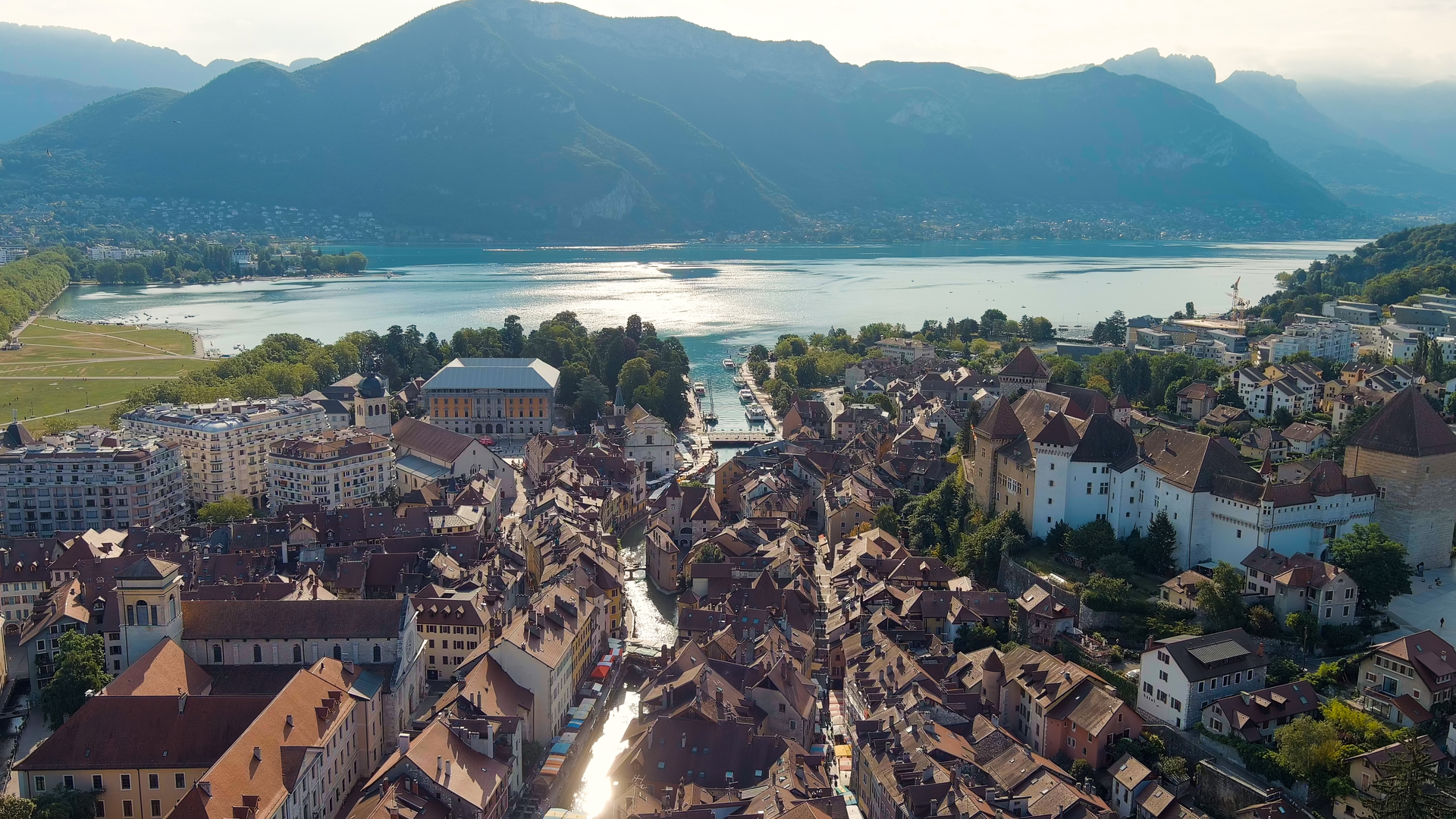
This is a flat, waterside city walk in Annecy, following the River Thiou from the old-town edge near Pont de la Halle (by Annecy Town Hall / Hôtel de Ville d’Annecy) to Pont de Tasset (in the Meythet area, northwest of central Annecy). At around 7 km (4.3 mi) with roughly 0 m (0 ft) of climbing, it’s ideal for an easy half-day stroll—more about pacing, crossings, and crowds than fitness.
Getting to the start (Pont de la Halle area)
Nearest landmark/address to aim for: Hôtel de Ville d’Annecy (Annecy Town Hall)—Pont de la Halle sits right beside it, over the Thiou. The old town (Vieille Ville) and the lakefront are a few minutes away on foot.
- By train + walk/bus: Arrive at Gare d’Annecy (Annecy railway station). From there, it’s typically a straightforward walk into the old town toward the Town Hall and the Thiou (roughly 15–25 minutes depending on route), or a short local bus hop if you prefer to save steps.
- By car: Use central Annecy parking (underground/structured car parks are common around the old town and lakefront). Expect tight streets, one-ways, and busy periods—especially weekends and summer. From parking, walk to the Town Hall and the river.
For navigation, load the route in HiiKER and keep an eye on which bank you’re on—Annecy’s canals and bridges make it easy to drift onto a parallel street without noticing.
What the walk is like underfoot
You’ll be on paved promenades, quays, and urban footpaths almost the entire way. The Thiou is short (about 3.5 km / 2.2 mi long as a river), so a 7 km outing usually means you’re following the river’s course with small detours, bank swaps, and connectors through parks and neighborhoods. (annecy-town.com)
Because the route is flat, the main “effort” variables are: - Crowds near the old town and photogenic canal sections - Frequent crossings (bridges, junctions, shared spaces with bikes) - Weather exposure (sun reflecting off water; slick paving after rain)
Along the Thiou: landmarks, scenery, and the best river moments
0.0–1.0 km (0.0–0.6 mi): Pont de la Halle and the old-town canal feel
Starting at Pont de la Halle, you’re immediately in classic Annecy waterside scenery—clear, fast-moving water, stone edges, and views that feel “Venice-like” in miniature. Near Pont de la Halle, there’s also a lake-level gauge by the Town Hall area—an understated but interesting detail that hints at how closely the city manages and monitors its water. (annecy-town.com)
In this first stretch, expect:
- Short sightlines that open and close as buildings and trees alternate along the banks
- Lots of photo-stops and slow-moving foot traffic
- Occasional interpretive signs (depending on the exact streets/quays you choose)
1.0–3.0 km (0.6–1.9 mi): Quays, small parks, and the “working river”
As you continue away from the densest old-town core, the Thiou starts to feel less like a postcard canal and more like a managed urban river corridor. Historically, this waterway supported local activity and craft/industry along its banks; Annecy (ancient Boutae) developed with artisans established near the Thiou in the Gallo-Roman period. (annecy-ville.fr)
You’ll notice:
- More open banks and longer straight sections
- A calmer rhythm with fewer tourist bottlenecks
- Occasional water-control structures and engineered edges that show the river is actively regulated (you may pass areas where older installations were modernized upstream of key bridges). (lac-annecy.com)
3.0–5.5 km (1.9–3.4 mi): Green corridor feel and quieter neighborhoods
Further northwest, the route often becomes pleasantly routine: water on one side, trees and residential streets on the other. This is where the walk feels most “local”—joggers, dog walkers, commuters on bikes. If you want a more nature-forward experience, this middle portion is usually where you’ll find it, even though you’re still in the city.
Wildlife is typical of a clean, fast-flowing urban river:
- Mallards and other ducks, especially in calmer eddies
- Small fish visible in clear sections
- Songbirds in riverside trees
(As always, wildlife presence varies by season and time of day.)
**5.5–7.0 km (3.4–4.3 mi): Approaching Pont

Surfaces
Asphalt
Unknown
Dirt
Concrete
Wood
Gravel
Paved
Comments and Reviews
User comments, reviews and discussions about the Pont de la Halle to Pont de Tassel via River Thiou, France.
average rating out of 5
0 rating(s)