Download
3D Flyover
Add to list
More
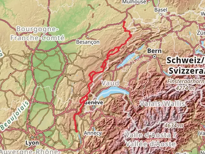
76.4 km
~3 days
1136 m
Multi-Day
“Embark on the historical and picturesque 76km GR de Pays - Randonnée des Forts trail encircling Belfort.”
The GR de Pays - Randonnée des Forts is a captivating loop trail that spans approximately 76 kilometers (about 47 miles) with an elevation gain of around 1100 meters (roughly 3609 feet), offering a medium difficulty level that is suitable for hikers with some experience. This trail encircles the city of Belfort, located in the Bourgogne-Franche-Comté region of France, and is known for its historical significance and natural beauty.
Getting to the Trailhead To begin your journey on the Randonnée des Forts, you'll want to make your way to the trailhead near Belfort. If you're arriving by public transport, Belfort is well-served by trains, including high-speed TGV services. From the Belfort train station, you can take local buses or a taxi to reach the starting point of the trail. For those driving, Belfort is accessible via the A36 motorway, and parking is available near the trailhead.
Navigating the Trail As you embark on the trail, you can expect a mix of forested paths, open meadows, and occasional road crossings. The route is well-marked with the standard red and white GR (Grande Randonnée) trail markers. For additional navigation support, HiiKER is an excellent tool to help you stay on track and provides detailed maps and waypoints.
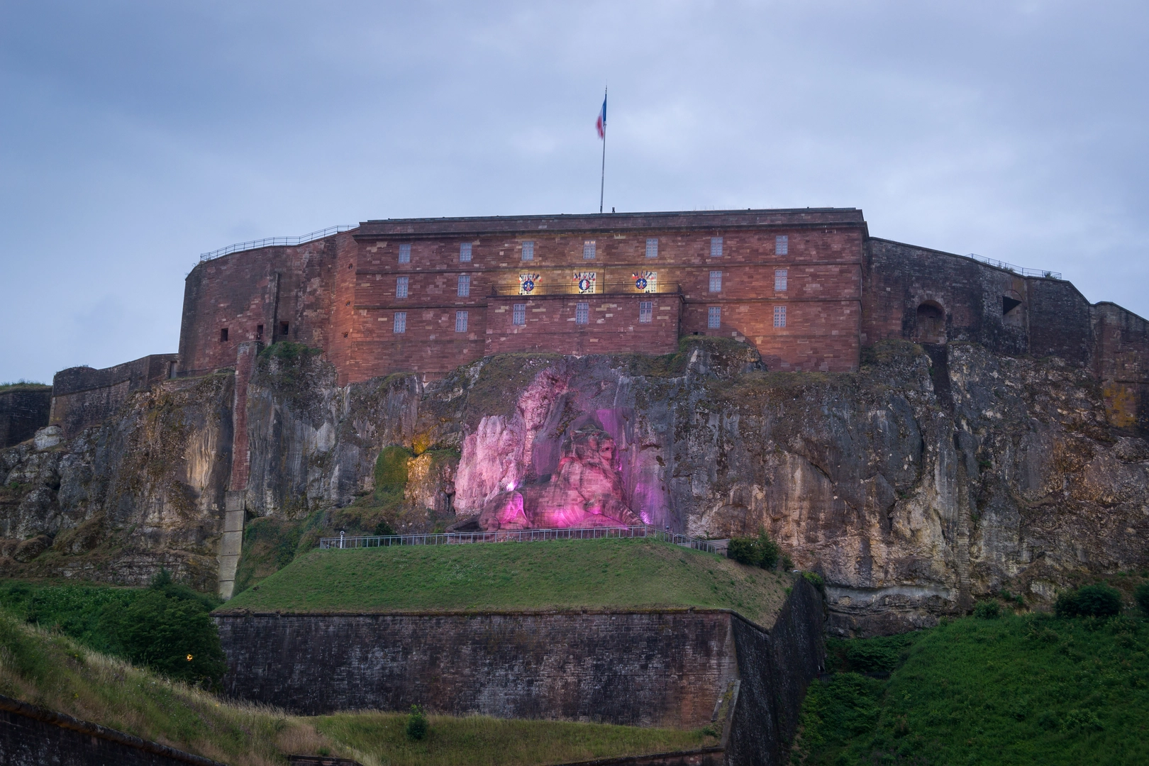
Historical Landmarks and Fortifications The trail's name, "Randonnée des Forts," hints at the historical fortifications you'll encounter along the way. The region is dotted with impressive forts and military structures, many of which date back to the 19th century and were part of the defensive system designed by the famous French military engineer Vauban. Notable forts include Fort de Bessoncourt and Fort de Giromagny, which offer a glimpse into the area's strategic military past.
Natural Highlights and Wildlife As you traverse the varied landscapes, you'll be treated to the diverse flora and fauna of the Vosges foothills. The trail takes you through deciduous forests where you might spot deer, foxes, and a variety of bird species. Spring and summer months are particularly vibrant with wildflowers and the lush greenery of the woodlands.
Terrain and Elevation Changes The trail includes a mix of flat sections and moderate climbs, with the most significant elevation gain occurring as you approach the Ballon d'Alsace, a notable peak in the southern Vosges Mountains. This area provides panoramic views of the surrounding landscape and is a highlight for many hikers.
Preparation and Tips Given the trail's length and elevation gain, it's advisable to plan for a multi-day hike, with overnight stays in local gîtes or bivouacs. Ensure you have a good pair of hiking boots, as the terrain can be rocky and uneven in places. Water sources are available but carrying a water filter or purification tablets is recommended. Lastly, be prepared for variable weather by packing layers and rain gear.
By taking the time to plan and prepare for the GR de Pays - Randonnée des Forts, you're sure to have an enriching experience exploring the natural beauty and historical depth of this unique region in France.

Frequently asked questions
How long does the GR de Pays - Randonnée des Forts usually take to hike?
The GR de Pays - Randonnée des Forts is 76.44 km long, so most hikers treat it as a multi-day loop rather than a single-day outing. A common pace for a medium-difficulty route of this length is about 4 to 6 days, depending on daily mileage, breaks, and how much time is spent at the fortifications around Belfort.
How difficult is the GR de Pays - Randonnée des Forts near Belfort?
The GR de Pays - Randonnée des Forts is generally rated medium, with 1,136 meters of total elevation gain over 76.44 km. That makes it manageable for hikers with some experience, but it is still a substantial route with repeated climbs, long walking days, and a full multi-day distance around Belfort.
Is the GR de Pays - Randonnée des Forts a loop trail around Belfort?
Yes. The GR de Pays - Randonnée des Forts is a loop route that circles Belfort and follows the city’s fortified belt. Tourism information for Belfort describes it as a circuit of roughly 82 km in 6 stages, while mapped hiking data for this route lists it at 76.44 km, so it is best understood as a multi-day loop with some variation depending on the exact line followed.
What can hikers see on the GR de Pays - Randonnée des Forts?
The route is built around Belfort’s military heritage, so the main highlights are the fortified sites and the wider fortified belt around the city. Hikers can expect a mix of woodland paths, open sections, and viewpoints tied to Belfort’s defensive landscape rather than a single summit objective.
Where do you start the GR de Pays - Randonnée des Forts and can you reach it by train?
The hike is based around Belfort, so the practical access point is the city itself. Belfort is served by rail, including mainline train connections, and local access onward is possible from the station area by bus, taxi, or on foot depending on the chosen starting point on the loop.
Are the GR de Pays - Randonnée des Forts waymarked on the ground?
Yes. As a GR de Pays route in France, the trail is waymarked with the standard GR-style red-and-white markings used on long-distance hiking routes. Even with those markings, the full 76.44 km circuit around Belfort is long enough that careful navigation is still useful, especially at road crossings and urban-edge sections.
Comments and Reviews
User comments, reviews and discussions about the GR de Pays - Randonnée des Forts, France.
5.0
average rating out of 5
5 rating(s)