Download
3D Flyover
Add to list
More
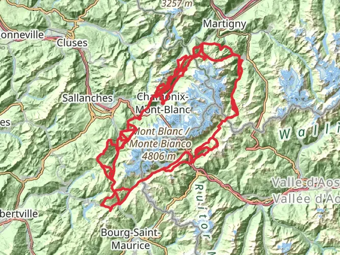
18.4 km
~2 days
4011 m
Multi-Day
“Embarking on the Goûter Route to Mont Blanc's summit promises a formidable trek through breathtaking alpine vistas, demanding expert mountaineering prowess.”
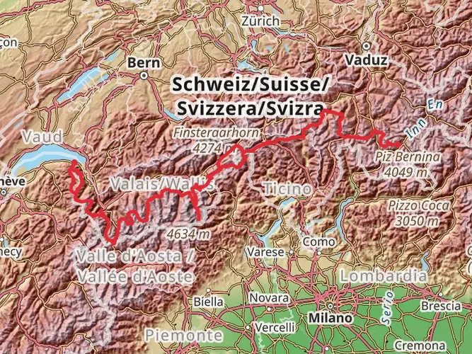
The Goûter Route, a challenging ascent to the summit of Mont Blanc, begins near the commune of Saint-Gervais-les-Bains, close to Bonneville, France. This iconic climb covers approximately 18 kilometers (11.2 miles) with an elevation gain of around 4000 meters (13,123 feet), making it a strenuous endeavor suitable only for experienced mountaineers.
Getting to the Trailhead To reach the trailhead, hikers can drive to Saint-Gervais-les-Bains or take public transport. The closest train station is in Le Fayet, from which you can catch a tram to the Nid d'Aigle at 2372 meters (7782 feet), the starting point of the hike during the summer months. Outside of tram operating times, hikers must start from Les Houches and take the Bellevue Cable Car followed by the Tramway du Mont Blanc to reach the Nid d'Aigle.
The Ascent The initial section of the route involves a steep climb to the Tête Rousse Hut at 3167 meters (10,390 feet), which is approximately 2.5 kilometers (1.55 miles) from the Nid d'Aigle. This part of the trail is rocky and can be covered in snow, requiring the use of crampons and an ice axe.
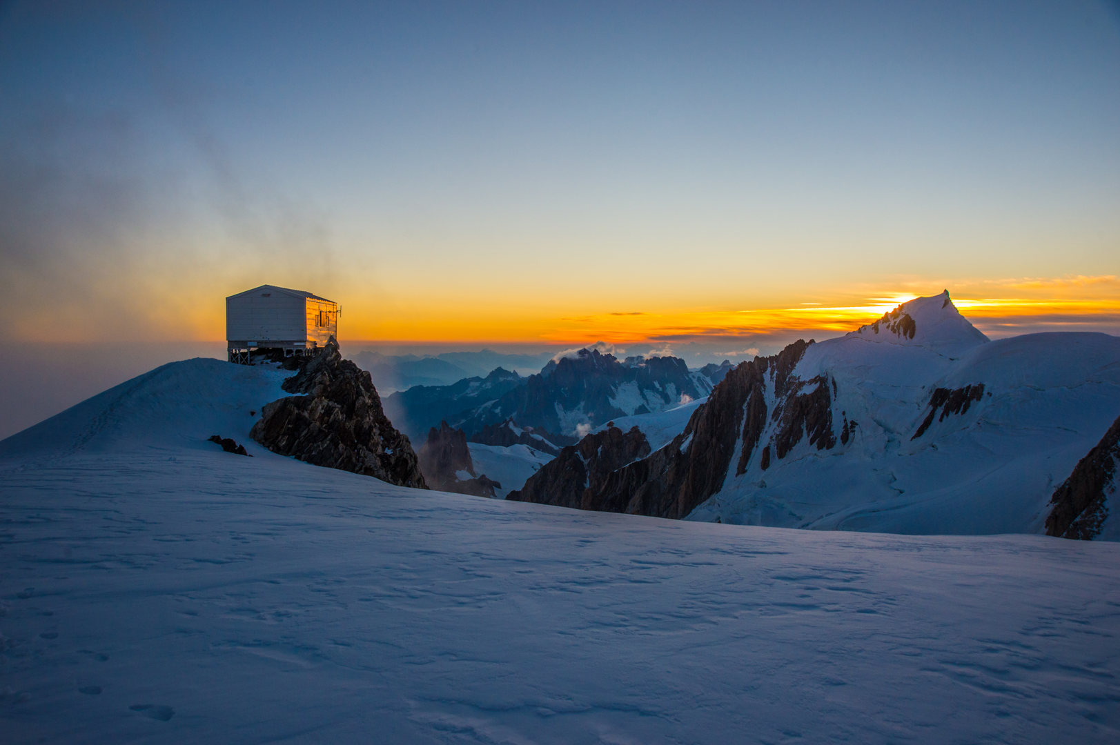
High Altitude Challenges From Tête Rousse, climbers face a notorious passage known as the Grand Couloir, a steep gully with a high risk of rockfall. Extreme caution is necessary here. Beyond the couloir, the path leads to the Goûter Hut at 3817 meters (12,520 feet), which serves as the main base camp for summit attempts. This section involves climbing over large boulders and can be physically demanding.
Summit Push The final push to the summit starts in the early morning hours to take advantage of stable weather conditions. Climbers traverse the Dôme du Goûter, then ascend the arête to the Vallot emergency refuge at 4362 meters (14,311 feet). From Vallot, the route becomes more technical, with crevasses and seracs posing potential hazards as hikers approach the summit ridge.
Historical Significance Mont Blanc has a storied history in mountaineering, being the birthplace of alpinism. The first recorded ascent was in 1786, marking the beginning of modern mountaineering. The region is also known for its breathtaking alpine scenery and unique flora and fauna, including ibex, chamois, and a variety of alpine birds.
Wildlife and Nature As hikers ascend, they may encounter alpine wildlife adapted to the harsh conditions. Vegetation is sparse at higher altitudes, but the lower slopes are rich with alpine meadows and forests. The views of surrounding peaks and glaciers are unparalleled, offering a glimpse into the raw beauty of the Alps.
Navigation and Safety Due to the technical nature of this climb, it is essential to be well-prepared with the proper gear and knowledge of high-altitude mountaineering. Hikers should use HiiKER to help with navigation and planning, as the app provides detailed maps and trail information. It is also highly recommended to hire a guide for this route due to the complex glacier travel and route-finding involved.
Preparation and Planning Climbers must be acclimatized to the altitude before attempting the summit. It is advisable to spend a few days at altitude and to climb some of the smaller peaks in the area as part of the acclimatization process. Due to the popularity of the route, booking huts well in advance is necessary, especially during the peak summer months.
Remember, the Goûter Route is a serious high-altitude climb and should only be attempted by those with the appropriate skills, experience, and equipment. Always check weather conditions and consult local guides before setting out.

Frequently asked questions
How difficult is the Goûter Route on Mont Blanc?
The Goûter Route is an extra-difficult multi-day mountaineering ascent of 18.41 km with 4,011 m of elevation gain. The hardest section is not just the altitude but the terrain: climbers move from Nid d'Aigle to Tête Rousse, cross the Grand Couloir above about 3,340 m, then continue to the Goûter Hut and higher onto Mont Blanc.
How long is the Goûter Route to reach Mont Blanc from Nid d'Aigle?
The Goûter Route listed here is 18.41 km in total, covering the ascent line from the Nid d'Aigle approach toward the summit of Mont Blanc and back along the same normal route. Key staging points on the climb are Nid d'Aigle at about 2,372 m, Tête Rousse Hut at 3,167 m, and the Goûter Hut at roughly 3,835 m before the upper mountain.
Where is the Grand Couloir on the Goûter Route?
The Grand Couloir sits above Tête Rousse Hut and below the Aiguille du Goûter on the normal Goûter Route from the French side of Mont Blanc. In practical terms, it is the exposed gully crossed after leaving Tête Rousse at 3,167 m and before reaching the scrambling ground that leads up to the Goûter Hut at around 3,835 m.
How do climbers cross the Grand Couloir on the Goûter Route?
On the Goûter Route, the Grand Couloir is crossed on foot between Tête Rousse and the Aiguille du Goûter, and it is widely regarded as the route's most serious objective hazard because of rockfall. The crossing is short, but it lies in a steep gully around 3,340 m, so timing, stable conditions, and full alpine judgment matter far more here than simple hiking fitness.
What is the Goûter Hut on the Goûter Route?
The Goûter Hut is the main high refuge used on the Goûter Route and stands at about 3,835 m on the Aiguille du Goûter. It is the usual high camp for summit bids after the lower stop at Tête Rousse Hut, which sits at 3,167 m below the Grand Couloir.
Where does the Goûter Route start, and how do climbers reach the trailhead?
The usual starting point for the Goûter Route is Nid d'Aigle above Saint-Gervais-les-Bains, reached by the Tramway du Mont-Blanc in season. Le Fayet is the nearest rail hub for the valley approach, and the tramway extension to Nid d'Aigle is scheduled to operate for summer 2026, making that station the standard access point for the route.
Comments and Reviews
User comments, reviews and discussions about the Goûter Route, France.
4.2
average rating out of 5
5 rating(s)