Download
3D Flyover
Add to list
More
53.1 km
~3 days
2483 m
Multi-Day
“Embark on a breathtaking 53-km Alpine adventure, teeming with wildlife and dotted with historical refuges.”
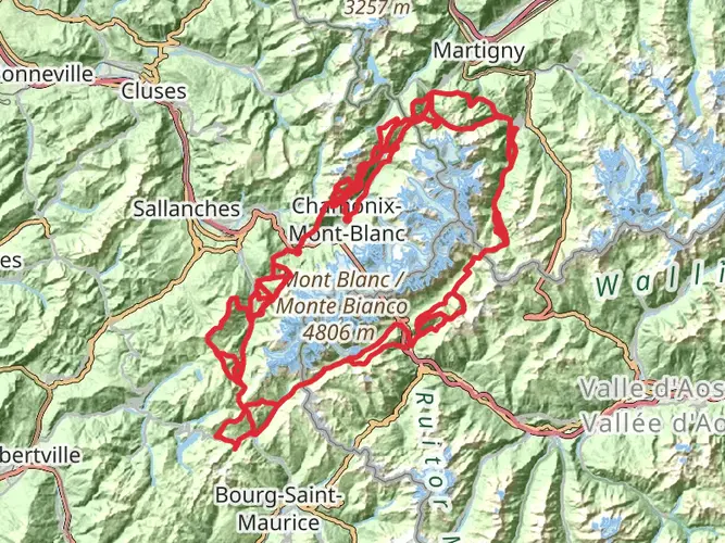
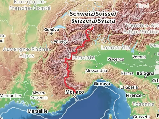
Embarking on the La Vanoise trail, hikers will traverse approximately 53 kilometers (about 33 miles) of the stunning French Alps, with an elevation gain of around 2400 meters (roughly 7874 feet). This point-to-point journey begins near Bourg-Saint-Maurice, a town well-connected by public transport. Travelers can take a train to Bourg-Saint-Maurice station and then a taxi or local bus to the trailhead. For those driving, parking is available in the vicinity of the trailhead.
Navigating the Trail
The La Vanoise trail is well-marked, but due to its length and difficulty, it's advisable to use a navigation tool like HiiKER to keep track of your progress and ensure you're on the right path. The trail offers a challenging trek through diverse terrains, including rocky paths, alpine meadows, and potential snowfields, even in summer.
Landmarks and Scenery
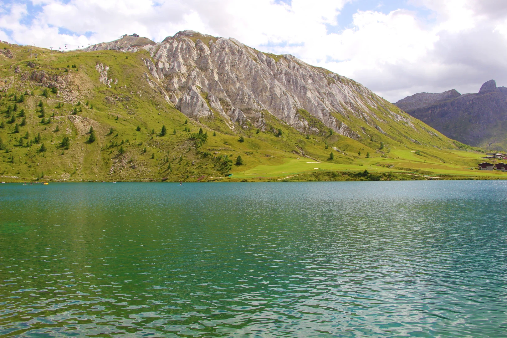
As you set out, the trail ascends through lush valleys, offering views of cascading waterfalls and the chance to spot local wildlife such as ibex and marmots. The path winds past glacial streams and alpine lakes, with the Vanoise National Park providing a backdrop of dramatic peaks.
Around the halfway mark, hikers reach the Col de la Vanoise, a mountain pass that offers panoramic views of the surrounding mountains, including the Grande Casse, the highest peak in the Vanoise massif. This area is steeped in history, with the Vanoise National Park being the first national park established in France, aimed at protecting the Alpine environment.
Flora and Fauna
The trail traverses through a variety of ecosystems, home to an abundance of flora and fauna. The alpine meadows bloom with a colorful array of wildflowers in the spring and summer months. The park is also a sanctuary for endangered species like the bearded vulture, and with some luck, hikers may catch a glimpse of these majestic birds.
Preparation and Safety
Given the trail's difficulty, hikers should be well-prepared with appropriate gear, including sturdy hiking boots, weather-appropriate clothing, and enough food and water for several days. It's also wise to carry a first-aid kit, a map, and a compass or GPS device, with HiiKER being a reliable digital option.
Access and Accommodation
Along the trail, there are various refuges where hikers can rest and spend the night. It's essential to book these in advance, especially during the high season. The trail ends in the vicinity of Modane, from where hikers can take public transport back to Bourg-Saint-Maurice or onward to other destinations.
Conclusion
The La Vanoise trail is a demanding but rewarding experience, offering an immersive journey through one of France's most breathtaking landscapes. With careful planning and respect for the natural environment, hikers will find this trail to be a memorable adventure in the heart of the Alps.

Frequently asked questions
Where is the La Vanoise hike near Bourg-Saint-Maurice, France?
La Vanoise is in the Vanoise massif in Savoie, in the French Alps, with Bourg-Saint-Maurice serving as one of the main gateway towns on the north side of the park. The route sits within the wider Vanoise National Park area and reaches the Col de la Vanoise, a high mountain pass in the heart of the massif.
How long is the La Vanoise hike and how much elevation gain does La Vanoise have?
La Vanoise is a 53.1 km multi-day hike with 2,483 meters of total ascent. That combination of distance and climbing puts it firmly in the extra difficult category, so it is better suited to experienced hikers comfortable with long alpine days and sustained elevation change.
How many days does the La Vanoise hike usually take?
Most hikers would split La Vanoise over about 3 to 4 days. At 53.1 km with 2,483 meters of ascent, it is too long and strenuous for most people as a single-day outing, especially on alpine terrain where rocky paths, steep climbs, and lingering snowfields can slow progress even in summer.
What is the highest point on the La Vanoise hike?
A key high point on La Vanoise is the Col de la Vanoise, which sits at about 2,515 to 2,517 meters above sea level. This pass is one of the best-known spots in the Vanoise massif and gives wide views toward Grande Casse, the highest peak in the massif at 3,855 meters.
Is the La Vanoise hike part of a GR route?
Yes. The Col de la Vanoise area is crossed by the GR55, one of the classic long-distance hiking routes in the Vanoise. La Vanoise also connects with well-known alpine trekking corridors around the park, so route-finding matters on this 53.1 km point-to-point hike, especially in poor weather or early-season snow.
Are dogs allowed on the La Vanoise hike?
Dogs are generally not allowed on the main protected sections of La Vanoise because the core zone of Vanoise National Park prohibits them, even on a leash. That rule is strictly enforced on trails around the Col de la Vanoise and the refuge area, so this is not a dog-friendly multi-day route.
What is the best time of year to hike La Vanoise?
The usual hiking season for La Vanoise is summer into early fall, with roughly mid-June through late September being the most reliable window. Even then, high sections around the Col de la Vanoise can hold snow patches, so July through September is often the safest period for a 53.1 km alpine trek.
Comments and Reviews
User comments, reviews and discussions about the La Vanoise, France.
4.8
average rating out of 5
5 rating(s)