Download
3D Flyover
Add to list
More
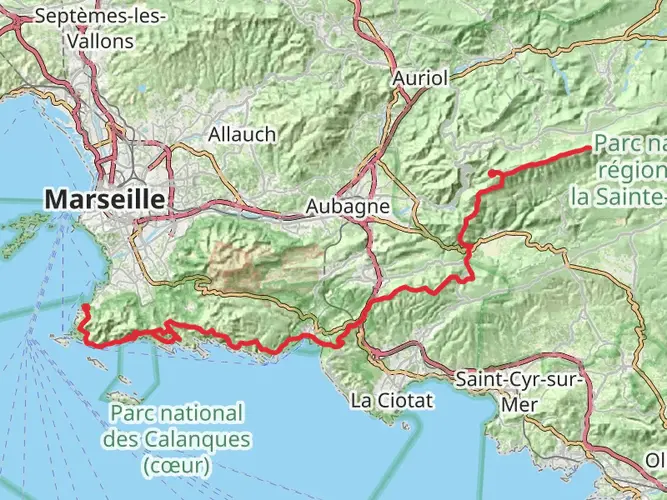
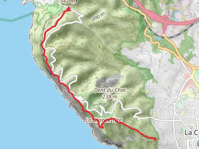
67.6 km
~3 days
897 m
Multi-Day
“Explore the stunning Grand Sentier de la Côte Bleue, a scenic Mediterranean journey steeped in history and natural wonders.”
Embarking on the Grand Sentier de la Côte Bleue, hikers will traverse approximately 68 kilometers (about 42 miles) of picturesque Mediterranean coastline with an elevation gain of around 800 meters (roughly 2625 feet). The trailhead is conveniently located near Châteauneuf-les-Martigues, France, which is accessible by public transport or car. For those opting for public transportation, the nearby town is served by regional trains and buses, making it a practical starting point for the hike.
Getting to the Trailhead
To reach the trailhead by car, hikers can drive to Châteauneuf-les-Martigues and follow local signage directing towards the coastal area where the loop begins. Parking is typically available in designated areas near the trail's entrance.
Navigating the Trail
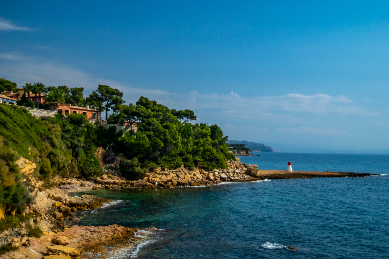
As you set out on the loop, the path will lead you through a diverse landscape of rocky inlets, sandy beaches, and lush pine forests. The trail is well-marked, but it's advisable to use a navigation tool like HiiKER to stay on track and be aware of your progress.
Landmarks and Scenery
One of the first significant landmarks you'll encounter is the quaint fishing village of Carry-le-Rouet, known for its seafood restaurants and vibrant marina. As you continue, the trail offers stunning views of the azure waters of the Mediterranean Sea, with opportunities to spot local wildlife such as seabirds and the occasional dolphin.
Flora and Fauna
The region is rich in biodiversity, with a variety of plant species that thrive in the coastal environment. Keep an eye out for the fragrant wild herbs like thyme and rosemary, as well as the Aleppo pines that provide shade along parts of the trail.
Historical Significance
The Côte Bleue area is steeped in history, with remnants of ancient settlements and maritime fortifications dotting the landscape. The trail passes near historical sites that reflect the region's past, including old watchtowers that once served as lookout points against invasions.
Challenges and Considerations
The trail is rated as medium difficulty, with some challenging sections that include steep inclines and rocky terrain. It's essential to wear appropriate footwear and carry sufficient water, especially during the warmer months. The total hike can take several days to complete, so plan for overnight stays in local accommodations or camping if permitted.
Preparation and Safety
Before setting out, ensure you have a detailed map or a digital navigation tool like HiiKER downloaded on your device. Check the weather forecast and be prepared for changes in conditions. It's also wise to inform someone of your hiking plans and expected return time.
By following these guidelines and being prepared, hikers can fully enjoy the natural beauty and historical richness of the Grand Sentier de la Côte Bleue.

Frequently asked questions
How long does the Grand Sentier de la Côte Bleue take to hike?
The Grand Sentier de la Côte Bleue is a 67.63 km multi-day route, so most hikers split it over 3 to 4 days. Local tourism information for the route describes it as a 62 km coastal itinerary typically walked in 3 to 4 days, which fits the same overall trail concept of linking the Côte Bleue sections between Martigues and Ensuès-la-Redonne.
Is the Grand Sentier de la Côte Bleue hard?
The Grand Sentier de la Côte Bleue is generally a medium-difficulty hike, with 897 m of total ascent over 67.63 km. Even though the elevation gain is moderate for the distance, the terrain is often rocky, stony, and uneven along the Mediterranean coast, so it suits hikers comfortable with long days on foot rather than beginners looking for a short promenade.
Can the Grand Sentier de la Côte Bleue be done by train?
Yes. One of the practical advantages of the Grand Sentier de la Côte Bleue is that much of the route can be accessed from stations on the Côte Bleue rail line between Marseille and Miramas. Stops including Niolon, Ensuès-la-Redonne, Carry-le-Rouet, Sausset-les-Pins, La Couronne, and Martigues connect directly to sections of the coastal trail, making stage hiking straightforward.
Where do you start the Grand Sentier de la Côte Bleue?
The Grand Sentier de la Côte Bleue is associated with Châteauneuf-les-Martigues, but the wider route is commonly walked across the Côte Bleue between Martigues and Ensuès-la-Redonne. Common access points include Martigues, La Couronne, Carry-le-Rouet, Niolon, and Ensuès-la-Redonne, depending on whether the plan is to hike the full route or tackle one stage at a time.
What towns and landmarks are on the Grand Sentier de la Côte Bleue?
The Grand Sentier de la Côte Bleue passes through some of the best-known places on this stretch of coast, including Martigues, La Couronne, Sausset-les-Pins, Carry-le-Rouet, Niolon, and Ensuès-la-Redonne. Notable features along the way include the calanque des Eaux Salées, the Niolon and Redonne coves, coastal pinewoods, small ports, and repeated views across the rade de Marseille.
Is the Grand Sentier de la Côte Bleue the same as the sentier des douaniers or GR Côte Bleue?
The names are closely related but not always used in exactly the same way. On the Côte Bleue, hikers often use sentier des douaniers, sentier du littoral, and GR 51 for overlapping coastal sections, while the Grand Sentier de la Côte Bleue refers to the larger linked hiking network that combines multiple marked loops and station-to-station sections along the same coastline.
Comments and Reviews
User comments, reviews and discussions about the Grand Sentier de la Côte Bleue, France.
4.33
average rating out of 5
6 rating(s)