Download
3D Flyover
Add to list
More
12.2 km
~4 hrs 31 min
1252 m
Out and Back
“A steep, committing climb through wildflower meadows to airy limestone above Lake Annecy—best savoured in calm weather.”
This is a short, steep, and very committing ascent to one of the most iconic viewpoints above Lake Annecy. At roughly 12 km / 7.5 mi round trip with about 1,300 m / 4,265 ft of elevation gain, expect sustained climbing, exposed limestone terrain near the top, and big consequences if weather turns. Plan for a full mountain day even though the distance looks modest.
Getting to the start (Montmin / Col de la Forclaz area)
By car - Drive to Montmin (Haute-Savoie, France) and continue toward the Col de la Forclaz road. Common starting points for this approach are the Montmin trailhead areas near the hamlet of “Les Prés Ronds” (a well-known access point for La Tournette routes from this side) or nearby signed parking pull-offs used by hikers. - In peak season, parking fills early; arrive early morning to avoid roadside overflow and to reduce exposure to afternoon thunderstorms.
By public transport - The most practical transit hub is Annecy. From Annecy, regional buses can get you partway toward the lake’s east side and the Talloires/Menthon-Saint-Bernard sector, but service directly into Montmin can be limited and seasonal. If you’re relying on transit, plan on: - Bus to the Lake Annecy east side, then - Taxi/rideshare to Montmin/Les Prés Ronds, or a long road-walk if you can’t secure a ride. - Check current schedules close to your date (routes change seasonally), and build in extra time for the return.
(If you share the exact coordinates of your intended start, I can convert them to the nearest named trailhead/landmark and tailor the directions precisely.)
What the route feels like, section by section
Trailhead to forest climb (approx. 0–3 km / 0–1.9 mi, +500–700 m / +1,640–2,300 ft)
From the Montmin side, the day begins immediately uphill. The lower trail typically threads through mixed woodland and steep mountain pasture edges. Footing is often a mix of dirt, roots, and embedded rock—grippy when dry, slick when wet. Because the grade is persistent, pacing matters: aim for a steady, sustainable effort early to avoid burning out before the technical upper mountain.
You’ll start getting partial openings through the trees where the lake and surrounding ridgelines appear, but the real “big view” payoff comes later. In spring and early summer, expect wildflowers in the meadows and a lot of insect activity; in shoulder seasons, damp leaves and mud can make the first descent section surprisingly treacherous.
Steepening terrain and limestone steps (approx. 3–5.5 km / 1.9–3.4 mi, +400–500 m / +1,300–1,640 ft)
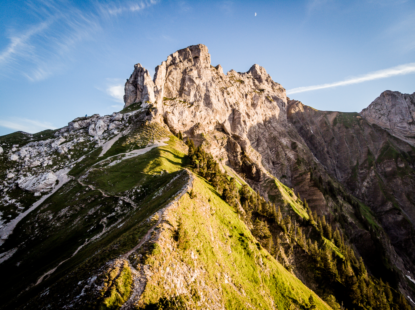
Higher up, the character shifts: the path steepens and becomes more rugged, with more exposed limestone underfoot. This is where many hikers start to feel the “Extra Difficult” rating—there’s less rhythm, more step-ups, and more hands-on balance in places.
Watch for: - Polished rock (especially after rain): it can be as slick as ice. - Loose gravel on bedrock: a common cause of slips on the way down. - Crowding on fine weekends: narrow sections can create bottlenecks.
Navigation is usually straightforward on this popular mountain, but in fog the upper slopes can feel confusing. If you use a digital tool, keep it to HiiKER and confirm you’re on the correct line before committing to steeper gullies or worn “shortcut” tracks.
Upper mountain: exposure, cables, and the summit block (approx. 5.5–6 km / 3.4–3.7 mi, +200–350 m / +650–1,150 ft)
Near the top, La Tournette’s limestone architecture becomes dramatic. The final approach commonly includes exposed traverses and short cable-assisted sections (conditions and exact placements can vary by route and maintenance). Even if the technical moves are brief, the exposure is real: a stumble can have serious consequences.
Only continue if: - Rock is dry (or you’re equipped and experienced for wet limestone), - Winds are manageable, - Visibility is adequate to judge terrain and spacing around other hikers.
The summit area is famous for its sweeping panorama over Lake Annecy and the surrounding massifs. Because the top is a magnet for people, keep an eye on footing around the edges and be patient—rushing in crowded, exposed terrain is where accidents happen.
Landmarks, nature, and wildlife to look for
- Limestone cliffs and karst features: La Tournette is a classic limestone mountain; you’ll see layered rock, ledges, and abrupt drop-offs that define the upper route.
- Alpine meadows: In season, these slopes can be rich with flowers. Stay on the trail to protect fragile plants and reduce erosion.
- Wildlife: It’s common in the Bornes/Aravis region to spot chamois on steeper grassy faces and marmots near meadow edges (often heard before seen). Birds of prey may ride thermals along the cliffs. Give animals space—especially early morning and near dusk.
Historical and regional context
The Lake Annecy region sits at a crossroads of Alpine travel and settlement history, with long-standing pastoral use of high meadows and seasonal movement of livestock. The surrounding Haute-Savoie landscape reflects centuries of mountain agriculture, trade routes through nearby passes, and the broader cultural blend

Surfaces
Unknown
Ground
Comments and Reviews
User comments, reviews and discussions about the La Tournette from Montmin, France.
average rating out of 5
0 rating(s)