Download
3D Flyover
Add to list
More
3.1 km
~59 min
226 m
Loop
“A short, punchy climb above Col de la Forclaz, rewarding steady feet with lake-and-peak panoramas.”
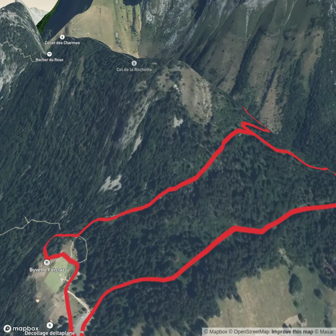
You’ll be climbing above the east shore of Lake Annecy on a short but punchy out-and-back that tops out at Pointe de la Rochette (1,491 m / 4,892 ft)—a small summit/shoulder above the Col de la Forclaz with outsized views toward La Tournette and the lake. Even at only ~3 km / ~1.9 mi and ~200 m / ~656 ft of gain, it earns a “Difficult” feel because the terrain can be steep, rooty, and slick, and the hillside is exposed in places.
Getting to the start (car + public transport)
Best landmark for the trailhead area: the Col de la Forclaz (74290 Talloires‑Montmin, Haute‑Savoie)—the famous paragliding pass above Lake Annecy. (smartmap.talloires-lac-annecy.com)
- By car: Drive to Col de la Forclaz via the D909/D42 approach depending on whether you’re coming from the lake side (Talloires/Menthon-Saint-Bernard) or from the Faverges side (Vesonne/Montmin valley). The pass is a major viewpoint and paragliding hub, so parking can be busy in good weather. (smartmap.talloires-lac-annecy.com)
- By public transport: From Annecy, there is a bus connection toward Talloires‑Montmin (Line 20); from there you’ll still need to plan a taxi/ride-share or a longer uphill approach to reach the pass area. Check current times and stop locations before you commit. (talloires-lac-annecy.com)
If your “hike head” is meant to be near Montmin village rather than the pass, the most practical “known place” to anchor your start is still the Col de la Forclaz area, because most short summit pushes to Pointe de la Rochette begin from the pass-side trail network.
What the hike is like (distance, gain, and pacing)
Plan for ~3 km / ~1.9 mi total and ~200 m / ~656 ft of ascent, typically 1.5–2.5 hours depending on how careful you are on the steeper bits and how long you linger at viewpoints. The summit area sits well above the pass, with the high point around 1,491 m / 4,892 ft. (altituderando.com)
Because this is a compact route, it’s tempting to under-pack—don’t. The slope can hold moisture, and the footing changes quickly from forest tread to more open, rocky ground.
On the trail: key sections and landmarks
0.0–0.6 km (0.0–0.4 mi): settling into the climb
From the Col de la Forclaz area, you’ll pick up a signed footpath that immediately commits to gaining height. Expect tight switchbacks, roots, and short rocky steps. Early on, the forest canopy can keep the ground damp even when the pass is sunny.
0.6–1.3 km (0.4–0.8 mi): steeper hillside travel + first “big lake” glimpses
As you climb, the trees thin in spots and the trail begins to feel more “ridge-like.” Small openings give you quick looks down toward Lake Annecy and across to the limestone bulk of La Tournette—a signature skyline from this side of the lake.
1.3–1.5 km (0.8–0.9 mi): final push to Pointe de la Rochette
Near the top, the path often narrows and can feel airy if you’re not used to steep side-slopes. The “summit” is more of a prominent point/shoulder than a broad dome, but the panorama is the payoff: lake, Bornes/Aravis silhouettes, and—on clear days—farther alpine horizons.
Navigation note: cell coverage can be inconsistent in folds of terrain; download the route in **H

Surfaces
Unknown
Dirt
Asphalt
Gravel
Comments and Reviews
User comments, reviews and discussions about the Pointe de la Rochette from Montmin, France.
average rating out of 5
0 rating(s)