Download
3D Flyover
Add to list
More
191.3 km
~9 days
7226 m
Multi-Day
“Embark on the GR 107 to traverse the Pyrenees' history-laden terrains and awe-inspiring vistas.”
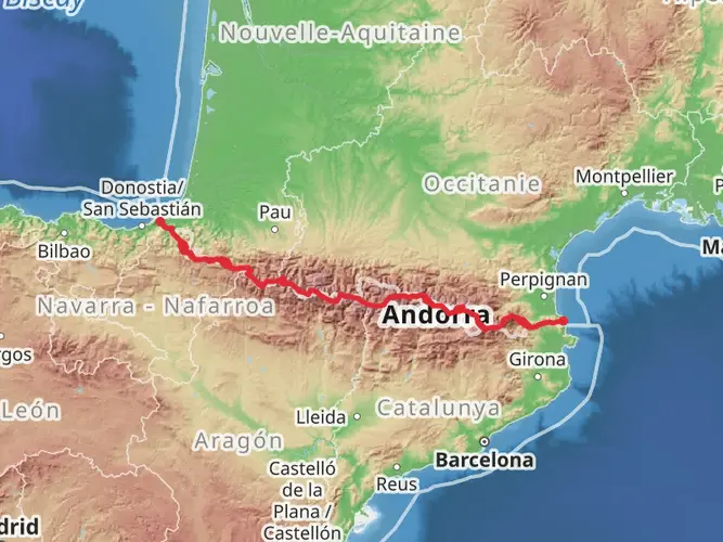
The GR 107, also known as the Chemin des Bonshommes, is a historical route that takes hikers through the stunning landscapes of the Pyrenees from near Foix, France, to Berga in Spain. This trail, approximately 191 kilometers (118.7 miles) in length with an elevation gain of around 7200 meters (23,622 feet), is a journey through time and nature.
Getting to the Trailhead
The trailhead is located near Foix, which is accessible by public transport or car. If you're coming by train, the nearest station is in Foix itself. From there, you can take a taxi or a local bus to reach the starting point of the trail. For those driving, parking is available in the vicinity of the trailhead. Make sure to check the local parking regulations and fees.
Historical Significance
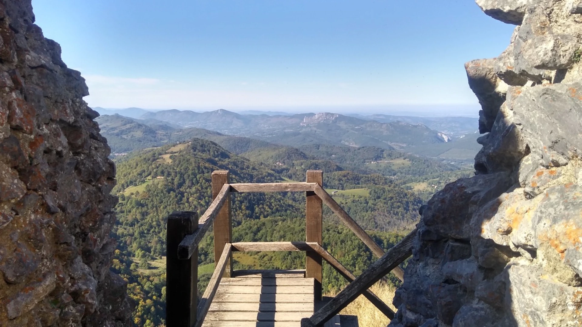
As you embark on the GR 107, you're retracing the steps of the Cathars, a group of Christian dualists from the 12th to the 14th century, who used this path as an escape route during the Albigensian Crusade. The trail is steeped in history, with numerous castles, fortresses, and old villages that tell the tale of a turbulent past.
Navigating the Trail
For navigation, HiiKER is an excellent tool to keep you on track. The app provides detailed maps and information that can be invaluable, especially in remote sections where the trail may be less marked.
Landmarks and Nature
The trail offers a variety of landscapes, from lush forests and meadows to rocky peaks and high-altitude pastures. You'll pass through the Parc Naturel Régional des Pyrénées Ariégeoises, which is home to an abundance of wildlife, including birds of prey, deer, and perhaps even the occasional glimpse of an isard, the Pyrenean chamois.
Key Sections of the Trail
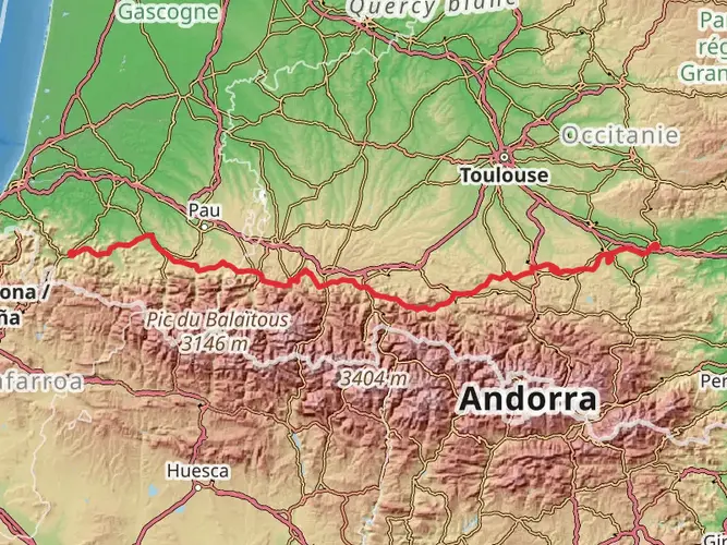
Montaillou to Refuge de Ruhle: This section is about 20 kilometers (12.4 miles) long with an elevation gain of approximately 1200 meters (3937 feet). It features the picturesque village of Montaillou and leads to the high-altitude Refuge de Ruhle, offering stunning panoramic views.
Refuge de Ruhle to Mérens-les-Vals: Spanning roughly 25 kilometers (15.5 miles), this segment takes you through varying terrains and past the beautiful Étang de Comte. The elevation gain here is around 1000 meters (3280 feet).
Mérens-les-Vals to Port d'Envalira: Covering about 30 kilometers (18.6 miles), this challenging stretch includes an ascent to the Port d'Envalira, the highest paved pass in the Pyrenees, with an elevation gain of 1500 meters (4921 feet).
Preparation and Planning
Given the trail's medium difficulty rating, it's essential to be well-prepared. Ensure you have suitable hiking boots, clothing for all weather conditions, and enough food and water. It's also wise to plan for overnight stays in the various refuges or shelters along the route.
Weather and Safety
The weather in the Pyrenees can change rapidly, so always check the forecast before setting out and be prepared for all conditions. Safety should be your top priority, so inform someone of your itinerary and expected return time.
Conclusion
The GR 107 is not just a hike; it's a journey through history and some of the most breathtaking scenery in the Pyrenees. With proper preparation and respect for the trail's natural and historical significance, it promises to be an unforgettable experience.

Frequently asked questions
How difficult is the GR 107 and who is the GR 107 best suited for?
The GR 107 is a difficult multi-day route. HiiKER lists it at 191.29 km with 7,226 m of climbing, so it is best suited to experienced long-distance hikers who are comfortable with sustained elevation gain, back-to-back mountain days, and a cross-border route through the Pyrenees between Foix and Berga.
How many days does the GR 107 usually take to hike from Foix to Berga?
A full thru-hike of the GR 107 is commonly done in about 10 to 13 days. The official GR 107 materials describe the route from Foix in Ariège to Berga in Catalonia as roughly a ten-day crossing, while stage-based itineraries often stretch it to 13 days depending on variants, lodging stops, and daily mileage.
What are the main GR 107 stages on the Chemin des Bonshommes?
The GR 107 is usually broken into stages between Foix and Berga, with common overnight stops including Roquefixade, Montségur, Comus, Mérens-les-Vals, Porta, Bellver de Cerdanya, Gósol, Peguera, and Berga. Stage plans vary by variant and accommodation, but the route is generally organized as a point-to-point Pyrenean crossing rather than a loop.
Where does the GR 107 start and finish?
The GR 107 starts in or near Foix in Ariège, France, and finishes at Berga in Catalonia, Spain. It follows the historic Chemin des Bonshommes across the Pyrenees, and official tourism information also notes the early section climbing out of Foix toward Montgailhard with views over the Ariège valley, Prat d'Albis, and Mont Fourcat.
Can the GR 107 be hiked in stages instead of all at once?
Yes. The GR 107 is regularly presented as a stage hike, and official route material breaks the Chemin des Bonshommes into daily sections rather than treating it as a single continuous push. That makes it practical to walk selected sections such as Foix to Montségur or later Catalan stages toward Berga, depending on time and logistics.
Is there a map for the GR 107 and is the route waymarked?
Yes. The GR 107 has an official interactive map, and it is a marked GR route on the ground. As a French Grande Randonnée, the trail uses the standard red-and-white GR waymarks on its French sections, but navigation still matters because this is a long, difficult mountain crossing with variants and an international border crossing into Spain.
Comments and Reviews
User comments, reviews and discussions about the GR 107, France.
5.0
average rating out of 5
4 rating(s)