Download
3D Flyover
Add to list
More
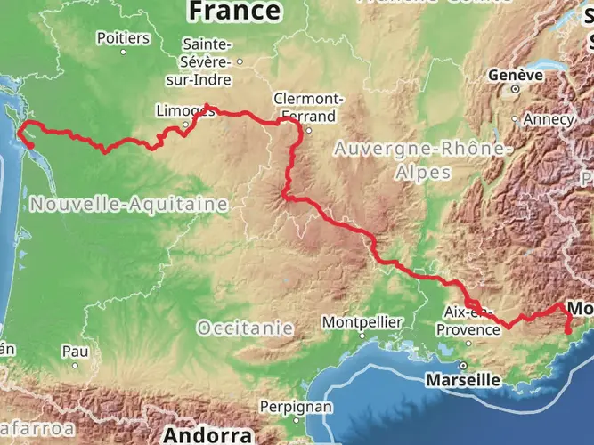
133.4 km
~7 days
6103 m
Multi-Day
“Trek through the GR 400's volcanic splendor, embracing Cantal's majestic peaks and rich heritage.”
Embarking on the GR 400 - Tour of Cantal Volcanoes is a journey through the heart of the Auvergne Volcanoes Regional Park, a landscape sculpted by volcanic activity. This challenging trek, covering approximately 133 kilometers (about 83 miles) with an elevation gain of around 6100 meters (approximately 20,000 feet), offers a deep dive into the natural beauty and geological wonders of central France.
Getting to the Trailhead The trailhead for the GR 400 is accessible near Murat, a charming town that serves as a gateway to the Cantal mountains. For those arriving by public transport, trains and buses connect to Murat from major cities like Clermont-Ferrand. If you're driving, Murat is reachable via the A75 motorway, and parking is available in the town.
Navigating the Trail The GR 400 is a point-to-point trail, so planning for transportation back from the end of the hike is essential. Hikers can rely on HiiKER for detailed maps and navigation assistance throughout the trek.
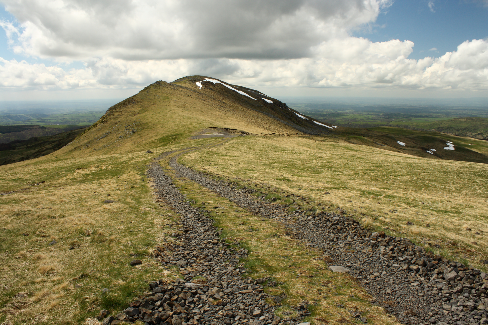
Volcanic Landscapes and Breathtaking Vistas As you set out from Murat, the trail quickly immerses you in the volcanic landscape, with the first section ascending towards the Plomb du Cantal, the highest peak in the Cantal range at 1855 meters (6086 feet). From here, the panoramic views of the surrounding valleys and peaks are a hiker's reward for the strenuous climb.
Flora and Fauna The path winds through diverse habitats, from open pastures to dense forests, home to a variety of wildlife. Keep an eye out for birds of prey soaring above and herds of Salers cattle, a breed native to the region, grazing in the fields. The flora is equally impressive, with wildflowers dotting the landscape in spring and summer.
Historical Significance The Cantal region is steeped in history, with the trail passing through ancient villages and near ruins that hark back to the Middle Ages. The area's volcanic past is ever-present, with the trail crossing numerous extinct volcanic peaks, known as puys, that have shaped the local culture and economy.
Landmarks and Highlights Key landmarks along the route include the Puy Mary, an iconic pyramidal peak and a symbol of the region. The GR 400 also takes hikers past the picturesque Puy Griou and the dramatic rocky outcrops of the Cirque de Falgoux.
Preparation and Safety Given the trail's difficulty rating and the remote sections it traverses, preparation is crucial. Hikers should be equipped with proper gear, including sturdy boots, weather-appropriate clothing, and sufficient food and water supplies. It's also wise to check the weather forecast and plan for sudden changes, as mountain conditions can be unpredictable.
Accommodation and Resupply Points There are several mountain huts and gîtes along the route where hikers can rest and resupply. It's advisable to book these in advance, especially during the peak hiking season.
Environmental Considerations As you journey through this protected area, it's important to practice Leave No Trace principles to preserve the environment for future generations. Stick to the marked paths, dispose of waste properly, and be respectful of wildlife and natural habitats.
Conclusion The GR 400 - Tour of Cantal Volcanoes is a trail that promises adventure, breathtaking scenery, and a deep connection with the natural and historical heritage of the Cantal region. With careful planning and respect for the environment, hikers can embark on an unforgettable journey through one of France's most remarkable landscapes.

Frequently asked questions
How long does the GR 400 - Tour of Cantal Volcanoes usually take to hike?
The GR 400 - Tour of Cantal Volcanoes is a 133.38 km difficult multi-day trek with 6,103 m of climbing, so it is typically planned as a week-long outing. Official GR descriptions commonly frame the full circuit from Murat as about eight days, though strong hikers sometimes complete it faster over long stages.
Where does the GR 400 - Tour of Cantal Volcanoes start and can it be hiked from Murat?
Yes. Murat is a recognized starting point for the GR 400 - Tour of Cantal Volcanoes, and the route is commonly described as departing from Murat in the Cantal mountains. Murat also works well logistically because it is a rail town and a practical base for parking, lodging, and resupply before setting out.
What are the main peaks and landmarks on the GR 400 - Tour of Cantal Volcanoes?
The GR 400 - Tour of Cantal Volcanoes circles the Cantal massif and passes through some of its best-known volcanic landscapes. Key landmarks linked with the route include Plomb du Cantal at 1,855 m, Puy Mary at 1,783 m, the Col de Prat de Bouc, Le Lioran, Mandailles, Thiézac, Le Claux, and the glacial valleys that radiate out from the old volcano.
Is the GR 400 - Tour of Cantal Volcanoes a loop trail or point-to-point hike?
The GR 400 - Tour of Cantal Volcanoes is generally treated as a circuit around the Cantal volcano, with Murat as one of the standard start points. Even though some hike listings classify it differently, the established GR route is used as a tour of the massif, making it practical to begin and finish in the same area.
How hard is the GR 400 - Tour of Cantal Volcanoes?
The GR 400 - Tour of Cantal Volcanoes is a difficult long-distance hike. Over 133.38 km it gains 6,103 m, and the route spends much of its time on cols, ridgelines, and steep mountain terrain in the Monts du Cantal, so it is better suited to experienced hikers with solid fitness and multi-day mountain walking experience.
Can the GR 400 - Tour of Cantal Volcanoes be reached by train or public transport?
Yes. Murat has a railway station, and both Murat and Le Lioran are used as access points for sections of the GR 400 - Tour of Cantal Volcanoes. That makes it possible to reach the hike by train from larger hubs in the region and also to break the route into shorter stages with rail access on part of the circuit.
Comments and Reviews
User comments, reviews and discussions about the GR 400 - Tour of Cantal Volcanoes, France.
4.0
average rating out of 5
3 rating(s)