Download
3D Flyover
Add to list
More
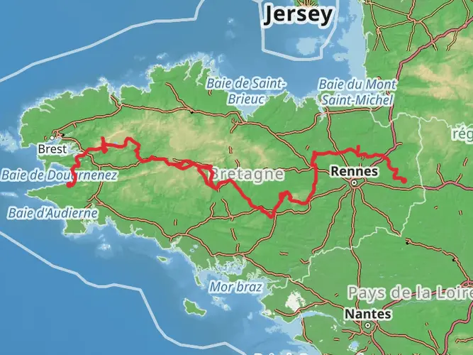
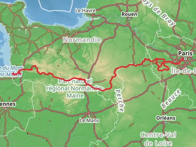
2093.0 km
~72 days
5854 m
Multi-Day
“Embark on the GR 34 for a stunning trek along Brittany's historic and scenic coastline, rich in natural and cultural wonders.”
Spanning approximately 2093 kilometers (1300 miles) with an elevation gain of around 5800 meters (19,000 feet), the GR 34, also known as the Custom Officers' Path, is a long-distance walking route that follows the Brittany coastline in France. This point-to-point trail, which begins near the historic town of Saint-Malo, offers hikers a challenging yet rewarding experience, with stunning coastal views, diverse landscapes, and a rich tapestry of wildlife and historical sites.
Getting to the Trailhead
To reach the starting point of the GR 34 near Saint-Malo, hikers can utilize various modes of public transportation. The town is well-connected by train, with direct TGV services from Paris Montparnasse taking about three hours. Upon arrival at the Saint-Malo train station, one can take a local bus or taxi to the trailhead. For those driving, Saint-Malo is accessible via the N137 highway, and parking is available in the area.
Navigating the Trail
The GR 34 is well-marked with the characteristic red and white stripes of Grande Randonnée routes. Hikers can also use the HiiKER app to navigate the trail, access detailed maps, and plan their journey with up-to-date information on waypoints and accommodations.
Coastal Wonders and Natural Landscapes
As you embark on the GR 34, you'll be greeted by the dramatic coastline of the Emerald Coast near Saint-Malo, with its imposing cliffs and sweeping views of the English Channel. The trail meanders through a variety of landscapes, including sandy beaches, rocky outcrops, and heathlands. The Pink Granite Coast near Ploumanac'h is a highlight, offering surreal, rose-hued rock formations that are a geological marvel.
Wildlife and Flora
The Brittany coast is a haven for birdwatchers, with numerous species such as the Atlantic puffin, guillemots, and razorbills. The trail also passes through areas of rich maritime flora, including heather, gorse, and various wildflowers that add a splash of color to the rugged terrain.
Cultural and Historical Significance
The GR 34 traverses a region steeped in history. The path was originally used by customs officers to prevent smuggling along the coast. Along the way, hikers will encounter historic landmarks such as the Vauban fortifications, ancient megaliths, and picturesque fishing villages that have retained their traditional Breton culture.
Preparation and Planning
Given the trail's length and difficulty, hikers should be well-prepared with appropriate gear, including sturdy footwear, weather-appropriate clothing, and navigation tools. It's advisable to plan for overnight stays in the various towns and villages along the route, where accommodations range from campsites to guesthouses.
Seasonal Considerations
The best time to hike the GR 34 is from April to October when the weather is milder. However, the trail can be hiked year-round, with each season offering a unique perspective of Brittany's rugged beauty. Always check the weather forecast and be prepared for changing conditions along this coastal path.
The GR 34 is a journey that will take you through some of the most breathtaking coastal scenery in France, offering a blend of natural beauty, wildlife, and historical intrigue. Whether you're a seasoned hiker or looking for a multi-day adventure, this trail promises an unforgettable experience.

Frequently asked questions
What is the GR 34 in France and where does the GR 34 start and finish?
The GR 34 is a long-distance coastal walking route in Brittany, also known as the Customs Officers’ Path. This hike is about 2,093.04 km long and is classed as difficult, following the shoreline from the Saint-Malo area along Brittany’s coast with famous stretches including the Emerald Coast and the Côte de Granit Rose.
How difficult is the GR 34 and is the GR 34 suitable for beginners?
The GR 34 is rated difficult, mainly because of its full length of 2,093.04 km and the repeated ups and downs of coastal terrain rather than one huge mountain climb. With about 5,854 m of total elevation gain, it is better suited to experienced long-distance hikers, although shorter day sections can be much more manageable than the entire route.
What is the best time of year to hike the GR 34 in Brittany?
The most practical months for hiking the GR 34 are generally late spring through early fall, when Brittany has longer daylight, milder temperatures, and more tourism services open along the coast. May, June, September, and early October are often the sweet spot for walking long sections, while midsummer can be busier around places like Saint-Malo and the Côte de Granit Rose.
Can you cycle on the GR 34 or is the GR 34 only for hiking?
The GR 34 is a walking route, not a bike trail. Many sections follow narrow coastal footpaths, cliff edges, steps, and uneven ground, so it is designed for hikers rather than cyclists and is not a practical through-route by bike.
How many stages does the GR 34 usually take to hike?
The number of stages on the GR 34 depends on daily mileage, but a full thru-hike usually needs many weeks because the route is about 2,093.04 km long. On some promoted sections of the trail, daily stages are commonly planned at roughly 10 to 25 km, so a complete end-to-end walk is normally broken into a large number of multi-day segments rather than tackled in one short trip.
Does the GR 34 include the Côte de Granit Rose and which part of the GR 34 is there?
Yes. One of the best-known parts of the GR 34 crosses the Côte de Granit Rose in Côtes-d’Armor, with popular walking sections around Lannion, Trébeurden, Trégastel, Perros-Guirec, and Ploumanac’h. That stretch is especially known for pink granite rock formations, sea views, and shorter stage options within the larger Brittany coast route.
Is accommodation easy to find on the GR 34 for a multi-day hike?
Accommodation is generally easier to find on the GR 34 than on many remote mountain trails because the route passes through a long chain of coastal towns, ports, and resort areas across Brittany. Availability is usually best outside the peak summer rush, while popular places such as Saint-Malo, Perros-Guirec, and other seaside stops can book up quickly in high season.
Comments and Reviews
User comments, reviews and discussions about the GR 34, France.
4.92
average rating out of 5
24 rating(s)