Download
3D Flyover
Add to list
More
112.2 km
~6 days
6345 m
Multi-Day
“Embark on a scenic, cultural trek through the alpine splendor of the Franco-Swiss Tour des Portes du Soleil.”
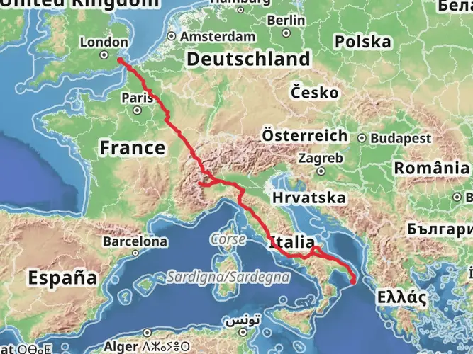
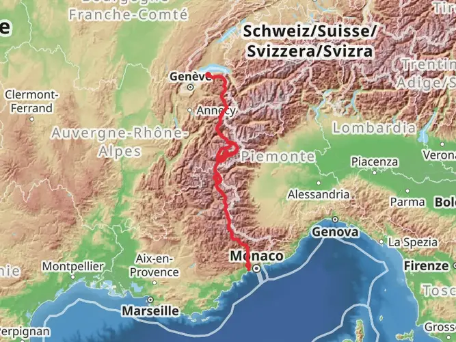
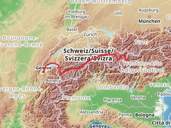
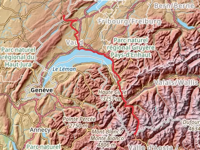
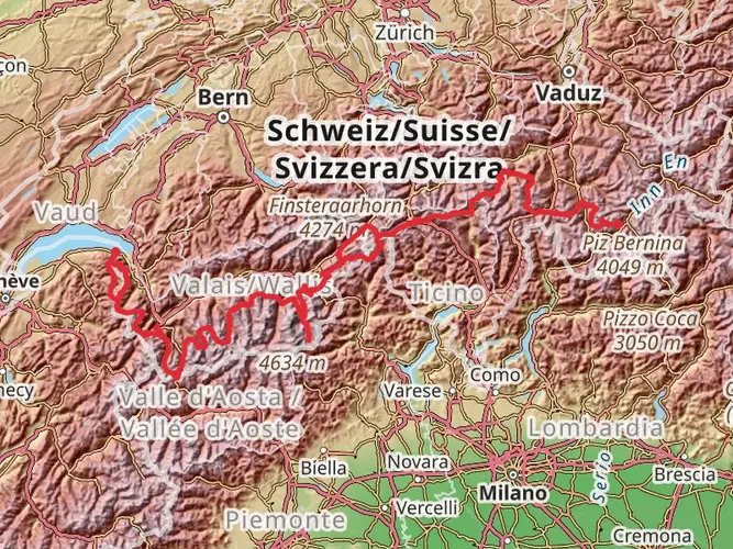
Embarking on the Tour des Portes du Soleil, hikers will traverse approximately 112 kilometers (about 70 miles) of varied terrain, with an elevation gain of around 6300 meters (nearly 20,700 feet). This loop trail, which begins and ends near Thonon-les-Bains in France, is a challenging adventure that weaves through both French and Swiss territory, offering a blend of cultural experiences and alpine scenery.
Getting to the Trailhead To reach the starting point of the Tour des Portes du Soleil, hikers can fly into Geneva International Airport and then take a bus or a train to Thonon-les-Bains. If driving, the trailhead is accessible via the A40 motorway, exiting towards Thonon. Parking is available in the area for those who prefer to drive.
Navigating the Trail The loop can be tackled in either direction, but many choose to hike in a clockwise manner. Hikers should prepare by downloading maps and trail information onto their devices using the HiiKER app, which will be an invaluable tool for navigation throughout the journey.
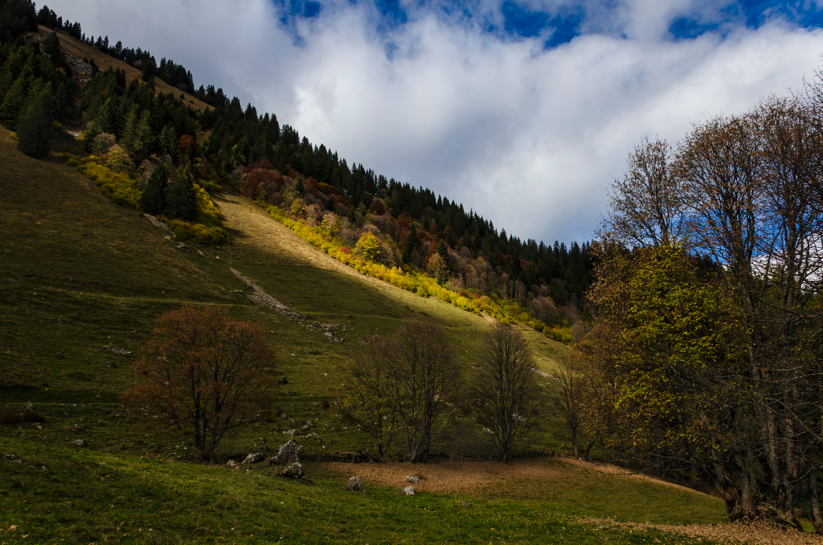
Trail Highlights and Landmarks The trail offers a mix of high alpine paths, lush meadows, and traditional alpine villages. As hikers ascend from Thonon-les-Bains, they will encounter the majestic Mont de Grange, one of the highest peaks in the Chablais Alps, offering panoramic views of the surrounding landscape.
Flora and Fauna The region is rich in biodiversity, with a chance to spot marmots, chamois, and ibex in the higher altitudes. The trail also winds through alpine forests and pastures, where hikers can admire a variety of wildflowers, especially in the spring and summer months.
Cultural and Historical Significance The Portes du Soleil area has a deep-rooted history, with many of the villages along the trail dating back to medieval times. The region was historically significant for trade and defense, and hikers will pass by several old fortifications and chapels that bear witness to this past.
Accommodation and Resupply Points There are numerous huts and guesthouses along the trail, allowing hikers to experience the local hospitality. It's advisable to book accommodation in advance, especially during the peak summer months. Resupply points are available in the villages, where hikers can stock up on food and other essentials.
Safety and Preparedness Given the trail's difficulty and the potential for rapidly changing weather conditions, hikers should be well-prepared with appropriate gear, including sturdy hiking boots, warm clothing, and rain gear. It's also important to be physically prepared for the demanding ascents and descents throughout the hike.
Environmental Considerations Hikers are encouraged to practice Leave No Trace principles to preserve the natural beauty of the area. This includes packing out all trash, being mindful of wildlife, and staying on marked trails to prevent erosion and protect delicate alpine vegetation.
By preparing adequately and respecting the natural and cultural heritage of the region, hikers can look forward to an unforgettable experience on the Tour des Portes du Soleil.

Frequently asked questions
How long is the Tour des Portes du Soleil hike and how many days does Tour des Portes du Soleil take on foot?
The Tour des Portes du Soleil is 112.16 km long with 6,345 m of total ascent, so it is firmly a multi-day trek rather than a long day hike. Most hikers split a route of this size into roughly 5 to 8 days, depending on daily mileage, weather, and how much time is spent on the bigger alpine climbs.
Is the Tour des Portes du Soleil a difficult hike?
Yes. The Tour des Portes du Soleil is rated Extra Difficult, and that fits the numbers: 112.16 km of distance and 6,345 m of climbing. It crosses serious alpine terrain in the Chablais with long ascents, steep descents, and high mountain sections that are better suited to experienced multi-day hikers.
Where does the Tour des Portes du Soleil start and finish?
The Tour des Portes du Soleil is a loop based near Thonon-les-Bains in Haute-Savoie, so it starts and finishes in the same general area. The route sits in the French Alps close to Lake Geneva and links parts of the French-Swiss Portes du Soleil region, making Thonon-les-Bains the main access town for arrivals and departures.
Does the Tour des Portes du Soleil cross into Switzerland?
Yes. The Tour des Portes du Soleil is a cross-border alpine circuit that links the French and Swiss sides of the Portes du Soleil region. That gives the walk a mix of landscapes and villages across both countries rather than staying entirely within one valley or one side of the border.
What are the main highlights on the Tour des Portes du Soleil hike?
One of the standout mountain landmarks on the Tour des Portes du Soleil is Mont de Grange, which rises to 2,432 m and is one of the dominant summits of the Chablais. The route area also includes classic alpine scenery such as high pastures, mountain villages, and broad viewpoints over the Abondance valley and surrounding French-Swiss peaks.
When is the best time of year to hike the Tour des Portes du Soleil?
The safest window for the Tour des Portes du Soleil is typically summer into early fall, when the higher mountain paths are usually clear of lingering snow. In the Mont de Grange area, hiking access is generally best from mid-June to mid-September, although exact conditions can shift with late snow, storms, or early autumn weather.
Are dogs allowed on the Tour des Portes du Soleil?
Dogs may be possible on some sections of the Tour des Portes du Soleil, but control is important because the route area includes alpine pastureland and protected terrain around Mont de Grange. In that sector, dogs are expected to be kept on a leash due to herds, wildlife sensitivity, and reserve rules, so this is not a carefree off-leash trek.
How do hikers get to the Tour des Portes du Soleil from Thonon-les-Bains?
Thonon-les-Bains is the main gateway for the Tour des Portes du Soleil and is well placed for arrivals by rail or road, with Geneva also commonly used as the nearest major airport. From the valley, local transport links connect toward hiking areas in the Abondance and Châtel sector, which helps with access to different points on the circuit.
Comments and Reviews
User comments, reviews and discussions about the Tour des Portes du Soleil, France.
4.7
average rating out of 5
10 rating(s)