Download
3D Flyover
Add to list
More
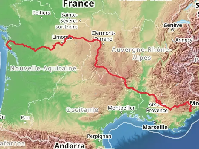
175.2 km
~7 days
3937 m
Multi-Day
“Embark on the GR 40's volcanic and historical odyssey through France's breathtaking Velay region.”
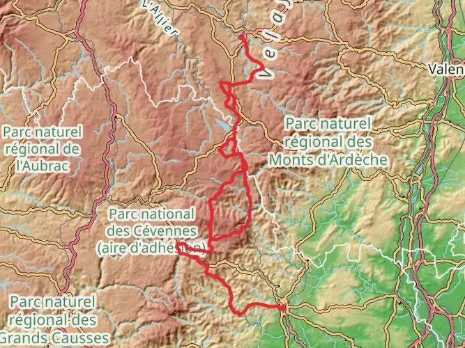
The GR 40, also known as the Tour des Volcans du Velay, is a captivating loop trail that spans approximately 175 kilometers (around 109 miles) with an elevation gain of about 3900 meters (nearly 12,800 feet). This medium-difficulty hike offers a unique blend of natural beauty, geological wonders, and historical richness, making it a must-visit for avid hikers.
Getting to the Trailhead
The trailhead for the GR 40 is located near the quaint town of Vorey, France. To reach the starting point, hikers can drive to Vorey and find parking in the town. For those preferring public transport, there are regional trains and buses that service Vorey, connecting it to larger cities such as Le Puy-en-Velay, which is well-linked to other parts of France.
Navigating the Trail
Hikers can rely on the HiiKER app for detailed maps and navigation assistance throughout the GR 40. The trail is well-marked with the characteristic red and white stripes of Grande Randonnée routes, guiding adventurers through the volcanic landscapes of the Velay region.
Trail Highlights and Landmarks
As you embark on the GR 40, you'll traverse a diverse range of terrains, from lush forests and pastures to rugged volcanic plateaus. The trail offers stunning panoramic views of the Loire Valley and the chance to explore the unique basaltic prisms at the Chaussée des Géants.
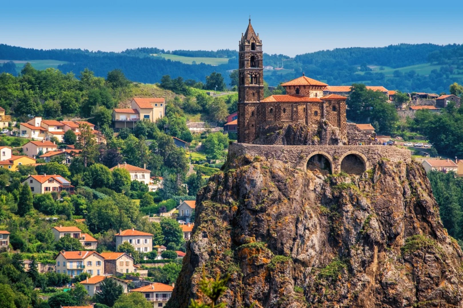
One of the most significant landmarks along the route is the historic Rocher de Costaros, a volcanic neck that stands as a testament to the region's geological past. Hikers will also encounter the picturesque village of Le Monastier-sur-Gazeille, known for its rich history and the starting point of the famed Stevenson Trail (GR 70).
Flora and Fauna
The GR 40 is a haven for nature enthusiasts. The trail passes through the Livradois-Forez Regional Natural Park, home to a variety of wildlife, including birds of prey, deer, and wild boar. The diverse vegetation ranges from beech and fir forests to high-altitude moors, offering a kaleidoscope of colors and scents throughout the seasons.
Historical Significance
The Velay region is steeped in history, with the GR 40 trail crossing paths with ancient Roman roads and medieval structures. The area is dotted with historic chapels, castles, and traditional stone villages that hark back to a bygone era. Hikers can immerse themselves in the local culture and history, with opportunities to visit museums and cultural sites along the way.
Preparation and Planning
Before setting out on the GR 40, hikers should ensure they are well-prepared with suitable gear for variable weather conditions. The trail can be completed in sections or as a whole, with accommodations ranging from campsites to guesthouses available in the villages along the route. It's advisable to carry sufficient water and snacks, although there are opportunities to resupply in the towns.
The GR 40 offers a moderate challenge for hikers, with some steep ascents and descents. It's recommended to plan for around 10 to 12 days to complete the entire loop at a comfortable pace, allowing time to enjoy the natural and historical sights along the way.

Frequently asked questions
How difficult is the GR 40 and what kind of hiker is it best for?
The GR 40 is generally rated medium difficulty. The full loop covers 175.18 km with 3,937 m of climbing, so it suits hikers comfortable with repeated long days, steady ascents, and multi-day route planning rather than beginners looking for a short day walk.
How many days does it usually take to hike the GR 40?
Most hikers split the GR 40 into roughly 10 to 14 days, depending on daily mileage and lodging plans. At 175.18 km, an 11-day schedule averages about 16 km per day, while a 14-day schedule brings stages closer to 12 to 13 km with more flexibility for village stops.
Where does the GR 40 start and finish near Vorey?
The GR 40 is a loop, so it starts and finishes in the same area, with Vorey-sur-Arzon commonly used as a trailhead. Vorey sits at the confluence of the Arzon and the Loire, and it is one of the recognized departure points for the Tour des Volcans du Velay.
Can the GR 40 be hiked in stages, or does the whole GR 40 need to be done at once?
The GR 40 is well suited to stage hiking rather than one continuous push. The route is commonly broken into daily sections between places such as Vorey-sur-Arzon and Allègre, and there is also a 61 km diagonal linked with Le Puy-en-Velay that creates two shorter loop options.
What landscapes and landmarks does the GR 40 pass on the Tour des Volcans du Velay?
The GR 40 circles through the volcanic landscapes of the Velay in Haute-Loire, mixing forest, pasture, river valleys, and old volcanic landforms. Well-known highlights on or around the route include the Loire Valley, Mont Bar peat bog area near Allègre, the Lac du Bouchet area, the Mézenc sector, the Meygal sucs, and villages such as Goudet, Les Estables, Vorey, and Allègre.
Is there accommodation along the GR 40, or is the GR 40 mainly for camping?
The GR 40 has accommodation options spaced around the loop, and local tourism services publish lodging specifically for the route from Vorey-sur-Arzon or Le Puy-en-Velay. That makes it practical to organize the hike as an inn-to-inn trek, although some hikers still choose to camp depending on stage length and availability.
How do hikers get to the GR 40 trailhead in Vorey without a car?
Vorey is accessible by regional public transport and is commonly used as a non-driving access point for the GR 40. It connects through the Haute-Loire network and is within reach of Le Puy-en-Velay, which is the main transport hub for the area and a common gateway to the route.
Comments and Reviews
User comments, reviews and discussions about the GR 40, France.
4.71
average rating out of 5
7 rating(s)