Download
3D Flyover
Add to list
More
96.7 km
~4 days
363 m
Multi-Day
“The Silver Comet Trail: a scenic, historic hike with amenities, suitable for many outdoor enthusiasts.”
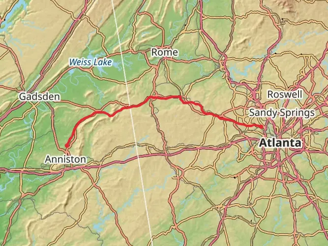
The Silver Comet Trail stretches approximately 97 kilometers (60 miles) and boasts a modest elevation gain of around 300 meters (984 feet), making it an accessible yet rewarding journey for many hikers. Originating near Cobb County, Georgia, this point-to-point trail is a converted rail-trail that offers a unique combination of natural beauty, historical significance, and well-maintained pathways.
Getting to the Trailhead
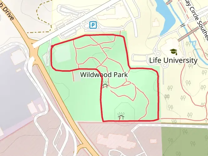
To reach the trailhead, located just outside of Atlanta, hikers can drive to Mavell Road Trailhead in Smyrna, Georgia. For those relying on public transportation, the closest MARTA station is H.E. Holmes, from which you can take a bus towards the Cumberland Transfer Center and then a short taxi or rideshare to the trailhead.
Navigating the Trail
As you embark on the Silver Comet Trail, you'll find the path well-marked and easy to follow. Hikers can utilize the HiiKER app for detailed maps and navigation assistance, ensuring a smooth trek. The trail is predominantly flat and paved, making it suitable for a wide range of outdoor enthusiasts, including cyclists and runners.
Historical Significance and Landmarks
The trail's name, Silver Comet, pays homage to the passenger train that once traversed this route. As you hike, you'll encounter several historical markers and restored train depots that offer a glimpse into the area's past. Notably, the trail crosses the Pumpkinvine Creek Trestle, a spectacular bridge providing expansive views and a sense of the engineering feats of the early 20th century.
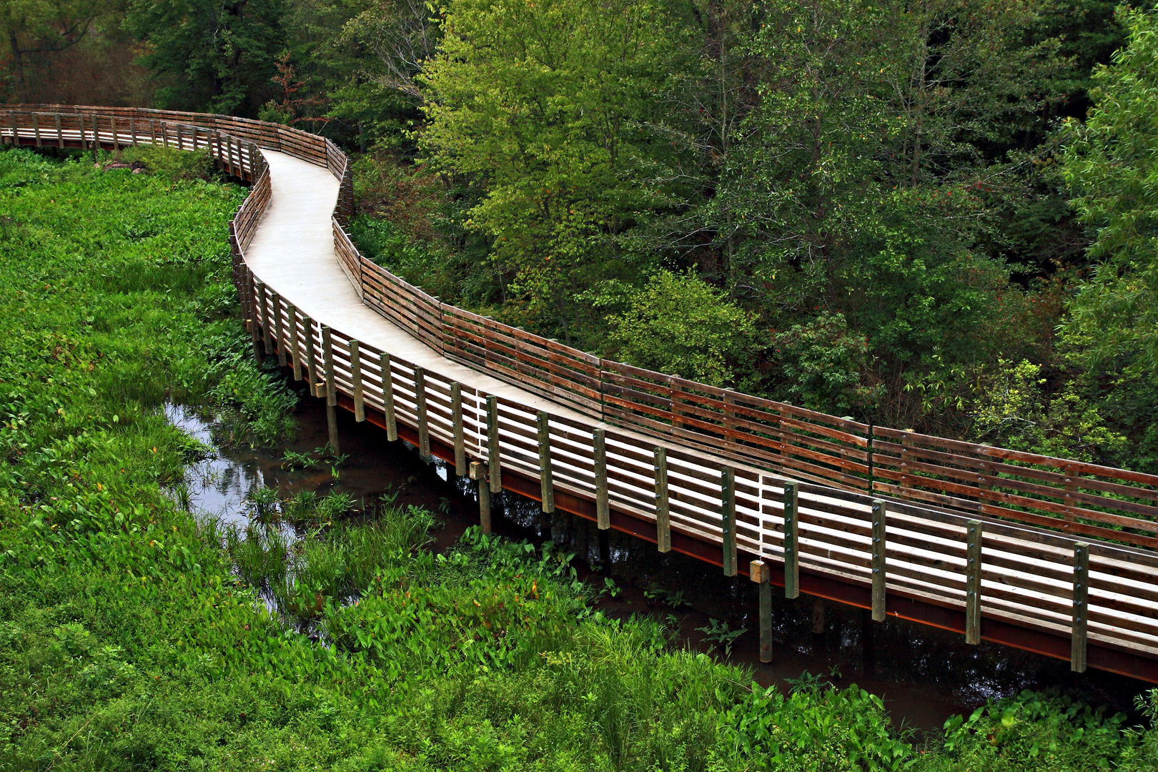
Natural Beauty and Wildlife
The Silver Comet Trail is enveloped by a diverse array of landscapes, from dense woodlands to open fields and wetlands. The changing scenery provides opportunities to spot local wildlife, including deer, birds, and an array of plant species. The trail is particularly stunning in the fall when the foliage transforms into a tapestry of vibrant colors.
Amenities and Points of Interest
Throughout the trail, there are numerous rest stops with benches, restrooms, and water fountains. These amenities make the Silver Comet Trail an excellent choice for long-distance hikers or those looking to enjoy a leisurely day hike. One of the highlights is the Brushy Mountain Tunnel, a 600-foot-long tunnel that offers a cool respite on warm days.
Safety and Preparation
While the trail is considered to have a medium difficulty rating, it's essential to prepare adequately for the journey. Ensure you have enough water, especially during the hotter months, and carry snacks or a packed lunch. The trail is shared with cyclists, so remain aware of your surroundings and follow trail etiquette.
Conclusion
The Silver Comet Trail is a gem in the Southeast, offering a mix of historical intrigue, natural beauty, and well-facilitated outdoor adventure. Whether you're looking to complete the entire trail or enjoy a segment, this trail promises a memorable experience for all who traverse its path.

What to expect?
Activity types
Frequently asked questions
How long is the Silver Comet Trail in Georgia?
The Silver Comet Trail is 96.67 kilometers long, or about 60 miles, across Georgia. It runs west from the Smyrna area in Cobb County toward the Alabama state line, making it one of the longest paved rail-trails in the Southeast.
How flat is the Silver Comet Trail for hiking?
The Silver Comet Trail is notably gentle for a long-distance route, with only 363 meters of elevation gain over 96.67 kilometers. Because it follows a former railroad corridor, the grades stay mild and the trail is widely considered an easy, mostly flat option for long walks, section hikes, and multi-day outings.
Where can you park for the Silver Comet Trail in Smyrna?
A common starting point for the Silver Comet Trail in Smyrna is the Mavell Road Trailhead, which is the main eastern access point near Cobb County. Other access and parking areas are available farther west along the corridor, but Mavell Road is the usual choice for hikers beginning near Atlanta.
What is the most scenic part of the Silver Comet Trail?
One of the standout scenic features on the Silver Comet Trail is the Pumpkinvine Creek Trestle, a long elevated crossing with open views over the creek corridor. The trail is also known for passing fields, streams, and wooded stretches, so many hikers rate the westward sections beyond the busier Smyrna start as the most visually rewarding.
What is the significance of the Silver Comet Trail?
The Silver Comet Trail follows the route of the former Silver Comet passenger train, which gives the trail its name and much of its character. Its rail-trail design explains the smooth grades and long straight stretches, and it remains one of Cobb County’s best-known linear parks and a major non-motorized route in Georgia.
Is the Silver Comet Trail safe for a long walk or multi-day hike?
The Silver Comet Trail is generally considered a straightforward and accessible route because it is paved, easy to follow, and separated from vehicle traffic for long stretches. For a safer outing, it helps to start at established trailheads such as Mavell Road, plan water and food stops in advance, and check for temporary closures, since sections can occasionally shut for maintenance work.
Comments and Reviews
User comments, reviews and discussions about the Silver Comet Trail, Georgia.
4.5
average rating out of 5
14 rating(s)