Download
3D Flyover
Add to list
More
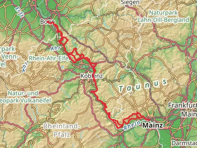
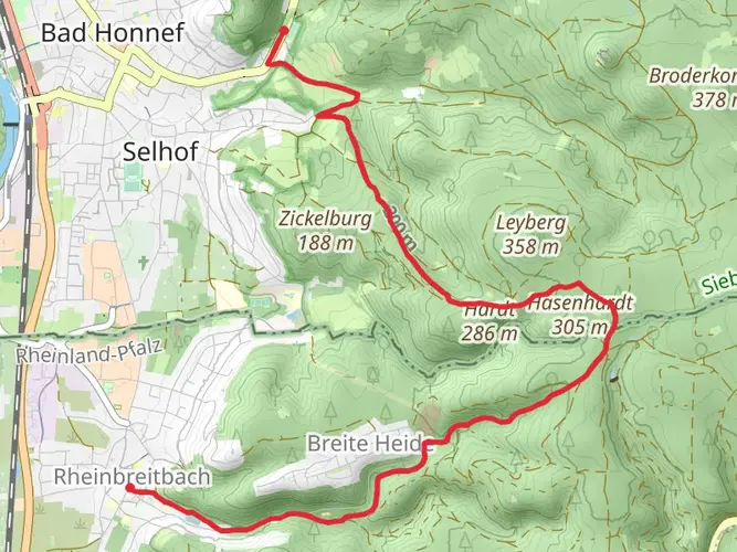
193.0 km
~8 days
5178 m
Multi-Day
“Embark on the RheinBurgenWeg for a captivating hike through history and Germany's stunning vistas.”
Embarking on the RheinBurgenWeg trail, hikers will traverse approximately 193 kilometers (about 120 miles) of scenic landscapes, with an elevation gain of around 5100 meters (approximately 16,732 feet). This point-to-point trail near Ahrweiler, Germany, is rated as medium difficulty, offering a blend of natural beauty and historical richness.
Getting to the Trailhead
The journey begins near the town of Ahrweiler, which is accessible by public transport or car. For those opting for public transport, the nearest train station is Ahrweiler Markt. From there, hikers can take a short taxi ride or a bus to the trailhead. If driving, parking is available in the area, and it's advisable to plan for transportation back from the endpoint of the trail, as it does not loop back to the start.
Navigating the Trail
Hikers can rely on HiiKER for detailed maps and navigation tools to guide them along the RheinBurgenWeg. The trail is well-marked with signage, making it easy to follow without the constant need for a map.
Historical Significance and Landmarks
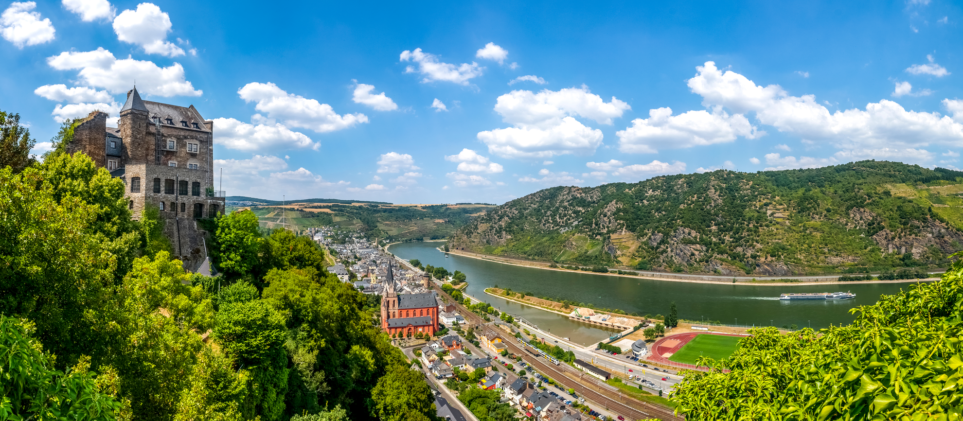
The RheinBurgenWeg trail is steeped in history, winding its way through the Upper Middle Rhine Valley, a UNESCO World Heritage Site. Along the route, hikers will encounter numerous castles, fortresses, and ruins, each with its own story. Notable landmarks include the imposing Marksburg Castle, the only hilltop Rhine castle that has never been destroyed, and Stolzenfels Castle, a shining example of 19th-century Rhine Romanticism.
Natural Beauty and Wildlife
The trail offers a diverse range of landscapes, from vineyard-covered hills to dense forests and panoramic river views. The changing terrain provides habitats for a variety of wildlife, including birds of prey, deer, and smaller forest creatures. In spring and summer, the trail is adorned with wildflowers, adding a splash of color to the green backdrop.
Trail Sections and Elevation
The RheinBurgenWeg can be divided into manageable sections, with each offering a different experience and varying degrees of elevation gain. For example, the segment from Boppard to St. Goar is about 14 kilometers (8.7 miles) and includes a climb to the lookout point at Vierseenblick, where hikers can enjoy a stunning view of the Rhine resembling four separate lakes.
Preparation and Planning
Hikers should prepare for the trail by packing appropriate gear for varying weather conditions, as the Rhine Valley can experience sudden changes. Sturdy hiking boots, water, snacks, and a first-aid kit are essential. It's also wise to carry a multi-tool and a whistle for emergencies.
Accommodation and Resupply Points
There are numerous towns and villages along the RheinBurgenWeg where hikers can find accommodation, ranging from hotels to guesthouses. Resupply points for food and water are also available, but it's important to plan these stops in advance, especially during the off-season when some establishments may be closed.
Conclusion
The RheinBurgenWeg is a trail that offers a rich tapestry of natural beauty and a deep dive into the historical heart of Germany. With careful planning and a spirit of adventure, hikers can embark on a memorable journey through one of Europe's most enchanting landscapes.

Frequently asked questions
How long is the RheinBurgenWeg and how many days does the full hike usually take?
The RheinBurgenWeg is 193.03 km long with about 5,178 m of climbing, so it is a substantial multi-day route rather than a weekend walk. The official trail is commonly broken into day stages, and most hikers need around 10 to 13 days to complete the full route depending on pace, weather, and how many castle and town stops are built into the itinerary.
Where does the RheinBurgenWeg start and finish?
The RheinBurgenWeg runs on the left bank of the Rhine between Bingen and Remagen-Rolandseck. In the Upper Middle Rhine Valley section, official stages include Bingen to Trechtingshausen, Bacharach, Oberwesel, St. Goar, Bad Salzig, Rhens, and Koblenz, while the northern section continues on toward Remagen-Rolandseck.
How is the RheinBurgenWeg divided into stages?
The RheinBurgenWeg is set up as a staged long-distance trail, and the official stage suggestions are flexible rather than fixed. In the Upper Middle Rhine Valley alone, published stages include Bingen to Trechtingshausen at 12.3 km, Trechtingshausen to Bacharach at 20.9 km, Bacharach to Oberwesel at 13.4 km, and St. Goar to Bad Salzig at 19.6 km, with more stages continuing through Rhens and Koblenz.
Which stage of the RheinBurgenWeg is considered the hardest?
One of the toughest published RheinBurgenWeg stages is Trechtingshausen to Bacharach, listed at 20.9 km and rated hard. That makes it a standout challenge on a route otherwise generally described as medium, especially compared with shorter middle-distance stages such as Oberwesel to St. Goar at 9.6 km or Bingen to Trechtingshausen at 12.3 km.
What are the main highlights on the RheinBurgenWeg?
The RheinBurgenWeg passes through the Upper Middle Rhine Valley UNESCO World Heritage landscape, a 65 km Rhine stretch known for castles, historic towns, and vineyard scenery. Notable sights linked with the route include Marksburg above Braubach, Stolzenfels Castle near Koblenz, Burg Rheinfels at St. Goar, the Loreley area, and medieval towns such as Bacharach and Oberwesel.
Is the RheinBurgenWeg easy to reach by train or bus?
Yes. The route is unusually practical for point-to-point hiking because local public transport serves the trail corridor well. Official trail information notes that every locality along the RheinBurgenWeg has public transport stops, and almost every town and village in the Rhine valley has a railway station, making it straightforward to hike single stages and return by train, bus, or boat.
Is the RheinBurgenWeg better for stage hiking or a full thru-hike?
The RheinBurgenWeg works well for both, but it is especially strong as a stage-hiking route. With a total length of 193.03 km, medium overall difficulty, and frequent rail-linked Rhine towns such as Bingen, Bacharach, Oberwesel, St. Goar, Rhens, and Koblenz along the way, it is easy to break the trail into shorter trips without losing the main castle-and-viewpoint highlights.
Comments and Reviews
User comments, reviews and discussions about the RheinBurgenWeg, Germany.
4.56
average rating out of 5
9 rating(s)