Download
3D Flyover
Add to list
More
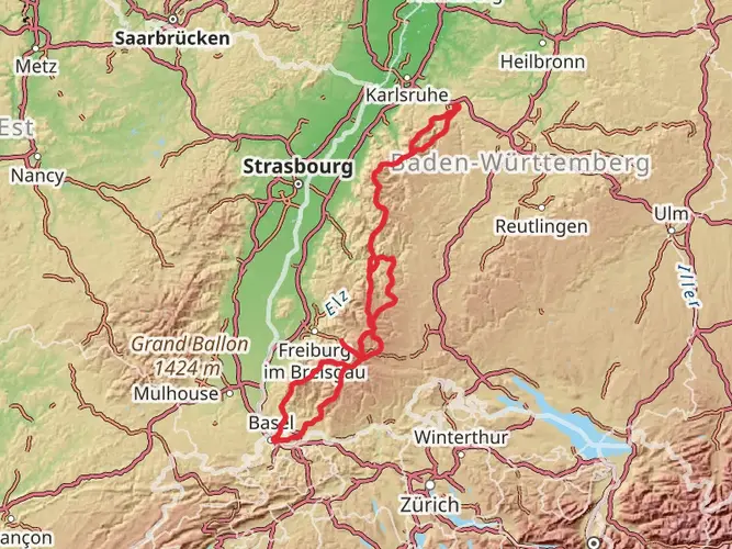
205.9 km
~8 days
3738 m
Multi-Day
“Embark on the Interregio-Wanderweg for a scenic trek through the Black Forest's cultural tapestry and diverse ecosystems.”
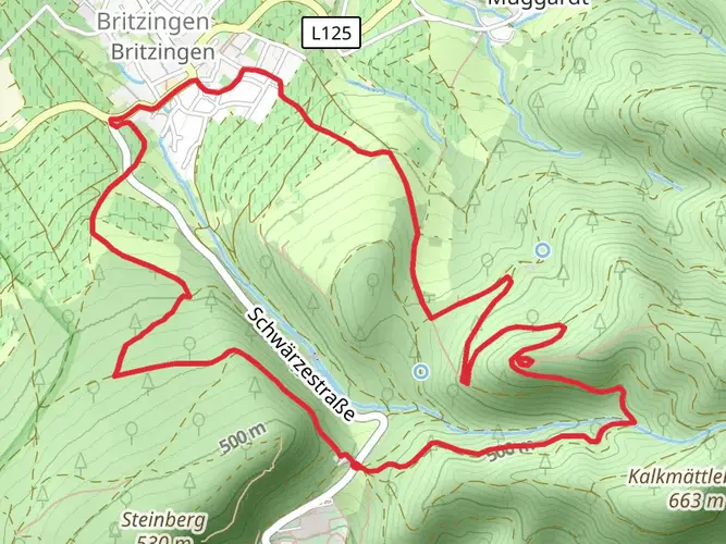
Embarking on the Interregio-Wanderweg, hikers will traverse approximately 206 kilometers (about 128 miles) of varied landscapes, with an elevation gain of around 3700 meters (roughly 12,139 feet). This loop trail, nestled near Breisgau-Hochschwarzwald in Germany, offers a medium difficulty rating, making it accessible to hikers with some experience.
Getting to the Trailhead
The journey begins near Breisgau-Hochschwarzwald, where hikers can arrive by car or public transport. For those driving, parking is available in the vicinity of the trailhead. Public transport users can take advantage of the local bus and train services, which connect to the nearby towns and cities, providing a convenient route to the starting point of the hike.
Navigating the Trail
As you set out on the Interregio-Wanderweg, ensure you have the HiiKER app downloaded for up-to-date trail maps and navigation assistance. The app will be an invaluable tool for staying on course and marking significant waypoints throughout your journey.
Landmarks and Scenery
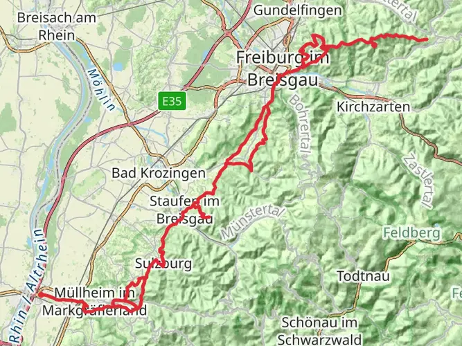
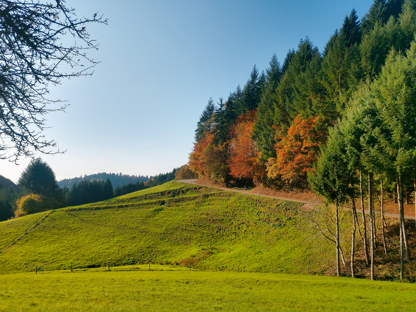
The trail meanders through the picturesque landscapes of the Black Forest, offering panoramic views and an immersive experience in nature. Hikers will encounter a mix of dense forests, open meadows, and rolling hills. The path also leads through charming villages, where traditional German architecture and culture are on full display.
Wildlife and Nature
The region is rich in biodiversity, with opportunities to spot local wildlife such as deer, foxes, and a variety of bird species. The changing seasons bring different flora and fauna to the forefront, with wildflowers blooming in spring and summer, and the forests taking on a golden hue in the fall.
Historical Significance
The Black Forest area is steeped in history, with the trail passing by sites that reflect the region's past. Hikers will learn about the area's historical significance, from ancient Roman roads to medieval castles. The trail itself may follow paths that have been trodden for centuries, adding a sense of timelessness to the journey.
Preparation and Planning
Before setting out, hikers should prepare for varying weather conditions and pack accordingly. The trail can be completed in sections or as a multi-day trek, with accommodations ranging from campgrounds to guesthouses available along the route. It's recommended to plan your stops in advance, especially during peak hiking seasons.
Elevation and Distance
The trail's elevation gain is gradual, with the most significant ascents occurring in the early stages. Hikers will cover a mix of flat and inclined terrain, with the highest points offering rewarding views of the surrounding area.
Conclusion
The Interregio-Wanderweg is a journey through the heart of the Black Forest, blending natural beauty with cultural and historical richness. With careful planning and a spirit of adventure, hikers will find this trail to be a memorable experience that showcases the best of what Germany's landscapes have to offer.

Frequently asked questions
How long does the Interregio-Wanderweg take to hike in full?
The Interregio-Wanderweg is about 205.94 km long, so it is usually treated as a multi-day route rather than a single outing. The established long-distance version is commonly divided into 11 stages, with daily hiking times ranging from about 3.5 to 8 hours. The longest single stage is the Mulhouse to Neuenburg am Rhein section at roughly 34.4 km.
Where does the Interregio-Wanderweg go, and does it connect Basel and Freiburg?
The Interregio-Wanderweg is a circular long-distance trail in the tri-border region of Germany, France, and Switzerland rather than a direct Freiburg-to-Basel path. It loops through stage towns including Neuenburg am Rhein, Bad Bellingen, Kandern, Steinen, Rheinfelden, Liestal, Aesch, Rodersdorf, Ferrette, Altkirch, and Mulhouse, making Basel-region access straightforward while staying south of Freiburg.
Is the Interregio-Wanderweg one of the Schwarzwaldverein long-distance trails?
The Interregio-Wanderweg is maintained jointly by three hiking organizations in the tri-border area: Schwarzwaldverein in Germany, Wanderwege beider Basel in Switzerland, and the Vosges Club in France. On the German sections it uses the Schwarzwaldverein trail network, where waymarking follows the local colored diamond system alongside the Interregio-Wanderweg symbol of three black rectangles on yellow.
What are the main highlights on the Interregio-Wanderweg in Germany?
The German sections include the Markgräflerland around Neuenburg am Rhein and Bad Bellingen, the pottery town of Kandern, Burg Rötteln near Lörrach, and the Hohe Flum lookout tower on the Dinkelberg. From Hohe Flum, views open across the southern Black Forest, the Vosges, the Jura, and even the Alps on clear days, before the route drops toward Rheinfelden on the High Rhine.
Does the Interregio-Wanderweg meet the Westweg or other famous Black Forest trails?
Yes. The Interregio-Wanderweg meets the Westweg in Kandern, and the next stage from Kandern toward Steinen initially runs together with the Westweg before branching off east near Rötteln Castle. Another connection comes on the Steinen to Rheinfelden stage, where the route meets the eastern variant of the Westweg on the Dinkelberg.
Is the Interregio-Wanderweg difficult, and how much climbing is there?
This route is best suited to hikers with solid endurance. The full trail covers about 205.94 km with 3,738 m of elevation gain, and the route is classified here as Difficult, so even though many individual stages are not technical, the cumulative distance and repeated climbs make it a demanding long-distance hike.
Can the Interregio-Wanderweg be hiked by public transport between stages?
Yes. One of the practical strengths of the Interregio-Wanderweg is that the stage towns are generally connected by local public transportation. Towns such as Neuenburg am Rhein, Bad Bellingen, Kandern, Steinen, Rheinfelden, Liestal, Aesch, Rodersdorf, Altkirch, and Mulhouse all serve as logical access or exit points, which makes section hiking much easier than on more remote Black Forest routes.
Comments and Reviews
User comments, reviews and discussions about the Interregio-Wanderweg, Germany.
5.0
average rating out of 5
4 rating(s)