Download
3D Flyover
Add to list
More
215.1 km
~8 days
3019 m
Multi-Day
“Embark on the WestfalenWanderWeg for a scenic, historical, and culturally rich German hiking adventure.”
Spanning approximately 215 kilometers (about 134 miles) with an elevation gain of around 3000 meters (nearly 9843 feet), the WestfalenWanderWeg offers a medium-difficulty trek through the diverse landscapes of North Rhine-Westphalia, Germany. The trail begins near the Ennepe-Ruhr-Kreis, a region known for its rolling hills and verdant valleys.
Getting to the Trailhead
To reach the starting point of the WestfalenWanderWeg, hikers can use public transportation or drive. The nearest significant landmark to the trailhead is the town of Hattingen. From there, public buses are available to bring you closer to the starting point. If driving, parking is available in the vicinity of the trailhead, allowing for a convenient start to the journey.
Navigating the Trail
The WestfalenWanderWeg is a point-to-point trail, meaning it does not loop back to the starting point. Hikers can rely on the HiiKER app for detailed navigation and mapping, ensuring they stay on the correct path throughout their trek.
Landmarks and Nature
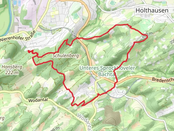
As you embark on the WestfalenWanderWeg, you'll traverse a variety of terrains, including dense forests, open meadows, and serene river valleys. The trail is well-marked, guiding hikers through the picturesque landscapes of the Sauerland and Teutoburg Forest.
One of the early highlights is the passage through the Ardeygebirge, a small mountain range offering panoramic views of the surrounding area. Approximately 40 kilometers (about 25 miles) into the hike, you'll encounter the historic town of Arnsberg, with its medieval architecture and the imposing Arnsberg Castle.
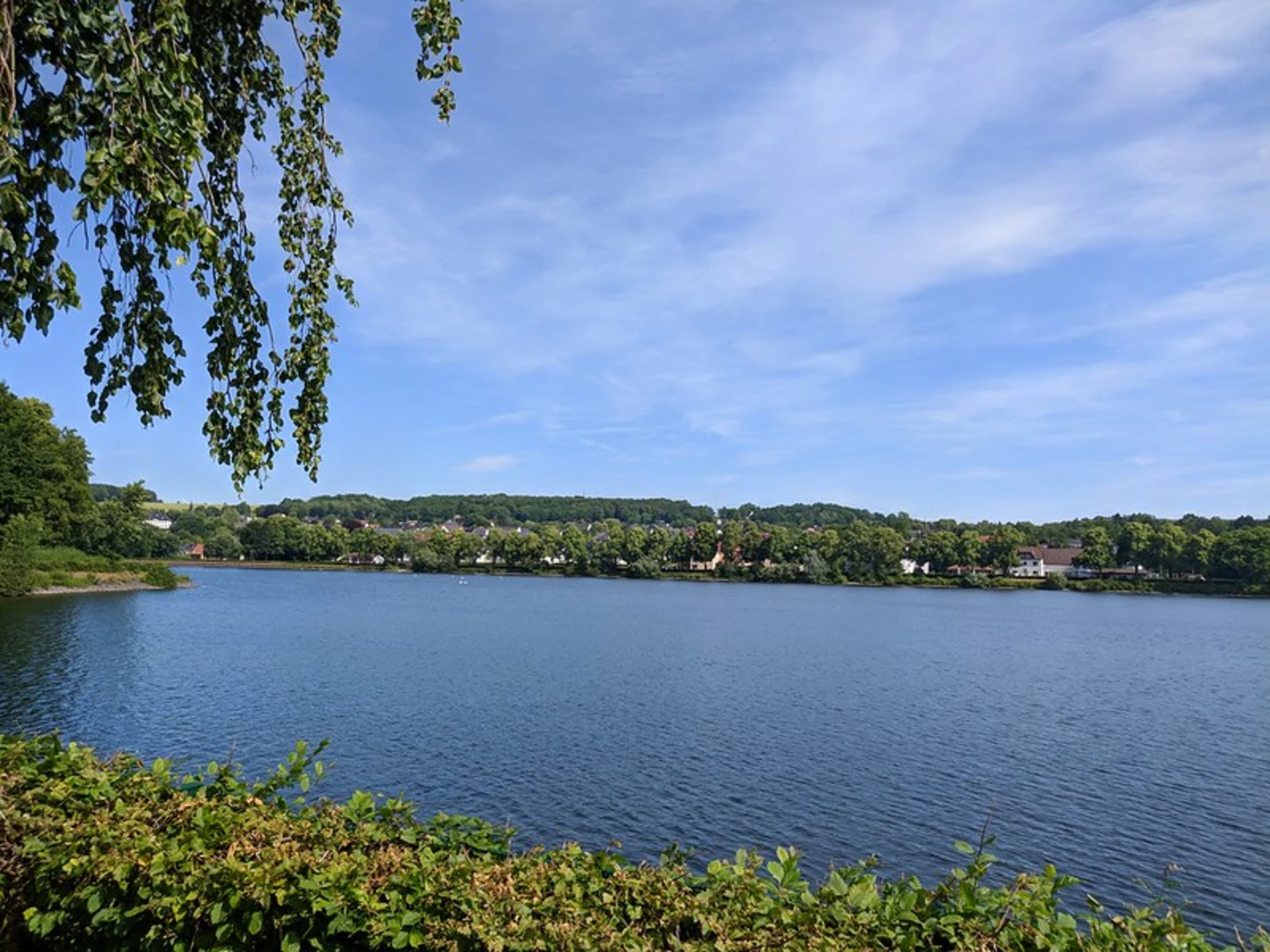
Continuing on, the trail meanders through the Möhne Valley, where the Möhne Reservoir serves as a stunning backdrop for photos and rest stops. This area is also a haven for birdwatchers, with numerous species inhabiting the wetlands.
Historical Significance
The WestfalenWanderWeg cuts through regions steeped in history. The trail passes near several ancient sites, including the Externsteine, a mysterious rock formation that has been a sacred site since prehistoric times. The trail also offers insights into Germany's more recent past, with remnants of old industrial areas now reclaimed by nature, providing a unique juxtaposition of history and natural beauty.
Wildlife and Flora
The diverse ecosystems along the WestfalenWanderWeg are home to a wide array of wildlife. Deer, foxes, and various bird species are commonly sighted. The trail also boasts a rich variety of plants and trees, with different species flowering throughout the seasons, offering a constantly changing landscape.
Preparation and Planning
Given the trail's length and varied terrain, hikers should prepare adequately. It's advisable to pack sufficient water, food, and weather-appropriate clothing. The trail includes several ascents and descents, so good hiking boots are essential for comfort and safety.
Accommodations along the WestfalenWanderWeg range from campgrounds to guesthouses, allowing hikers to choose their preferred level of comfort. It's recommended to book these in advance, especially during peak hiking seasons.
Conclusion
The WestfalenWanderWeg is a trail that offers a blend of natural beauty, historical exploration, and a true sense of adventure. Whether you're a seasoned hiker or someone looking to immerse yourself in the German countryside, this trail provides an enriching experience that showcases the heart of Westphalia.

Frequently asked questions
How long is the WestfalenWanderWeg and where does the WestfalenWanderWeg start and finish?
The WestfalenWanderWeg is 215.11 km long with 3,019 m of total ascent. It is a point-to-point long-distance trail that starts in Hattingen in North Rhine-Westphalia and finishes in Altenbeken at the Eggegebirge, crossing Westphalia from the Ruhr area toward eastern uplands.
How many stages does the WestfalenWanderWeg have?
The WestfalenWanderWeg is commonly divided into 11 stages. That stage structure fits the trail’s 215.11 km total length, which works out to roughly 19.5 km per day on average, although individual stages vary depending on the towns and access points used for overnight stops.
Where does WestfalenWanderWeg stage 1 go, and how hard is the first day?
Stage 1 of the WestfalenWanderWeg runs from Hattingen to Witten and is about 19.8 km long. It begins at Hattingen station and passes landmarks including the Ruhrtalblick viewpoint, the Alte Ruhr-Katzenstein nature reserve, the Muttental, Zeche Nachtigall, and Schloss Steinhausen before reaching Witten.
Is the WestfalenWanderWeg the same as the Ruhrhöhenweg?
The WestfalenWanderWeg is not the same trail as the Ruhrhöhenweg, but they do overlap. The route from Hattingen through Witten and onward toward Schwerte follows the Ruhrhöhenweg corridor before the WestfalenWanderWeg continues east across Westphalia toward places such as Werl, Möhnesee, Rüthen, Büren, Wewelsburg, and Altenbeken.
Does the WestfalenWanderWeg go through Wuppertal?
No. The WestfalenWanderWeg starts in Hattingen and heads through places including Witten, Wetter, Herdecke, Dortmund, Schwerte, Fröndenberg, Werl, Möhnesee, Rüthen, Büren, Wewelsburg, and Altenbeken. Wuppertal is not one of the main towns on the route.
Is the WestfalenWanderWeg well marked, or is navigation difficult?
The WestfalenWanderWeg is generally considered a medium-difficulty long-distance hike and is waymarked on the ground. Because it is a 215.11 km point-to-point route crossing multiple regions and settlements, navigation is easier with a detailed map or offline route guidance, especially when breaking the trail into stages.
Can the WestfalenWanderWeg be reached by public transportation?
Yes. The western end of the WestfalenWanderWeg is in Hattingen, which has bus and rail connections, and the first stage is described as starting at Hattingen station. The eastern end at Altenbeken is also a rail town, making the route practical for a one-way hike with public transportation at both ends.
Comments and Reviews
User comments, reviews and discussions about the WestfalenWanderWeg, Germany.
4.82
average rating out of 5
11 rating(s)