Download
3D Flyover
Add to list
More
118.2 km
~5 days
2163 m
Multi-Day
“Trek the historic Ausoniusweg for scenic and cultural immersion through Germany's heartland.”
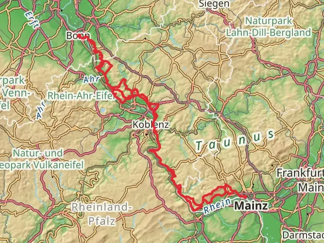
Embarking on the Ausoniusweg trail, hikers will traverse approximately 118 kilometers (about 73 miles) of varied landscapes, with an elevation gain of around 2100 meters (approximately 6890 feet). This point-to-point trail begins near the region of Mainz-Bingen in Germany, offering a medium difficulty rating that caters to hikers with some experience.
Getting to the Trailhead
To reach the starting point of the Ausoniusweg, travelers can use public transportation or drive. The nearest significant landmark is the town of Bingen am Rhein. If arriving by train, Bingen Hauptbahnhof is the main station, with connections from major cities like Frankfurt. From the station, local buses or taxis can take you closer to the trailhead. For those driving, parking is available in the area around Bingen, where you can begin your hike.
Navigating the Trail
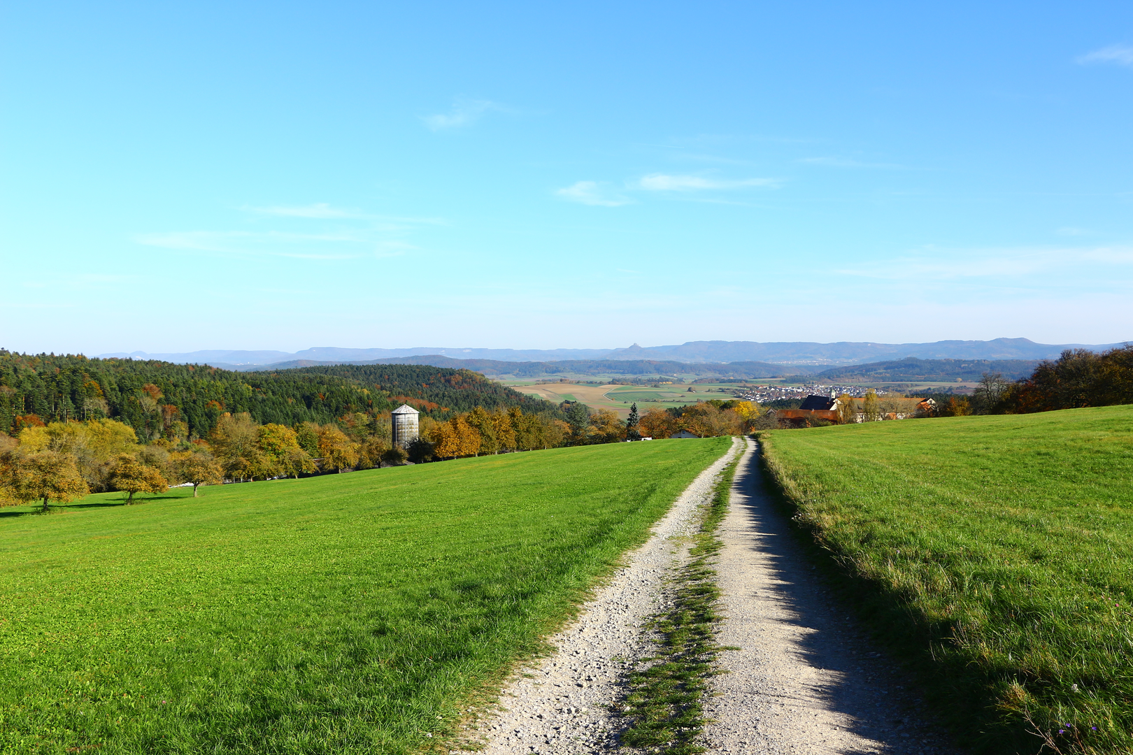
The Ausoniusweg follows the historical path of a Roman road, leading hikers through a rich tapestry of vineyards, forests, and open fields. The trail is well-marked, but carrying a reliable navigation tool like HiiKER is advisable to stay on track and be aware of upcoming waypoints.
Historical Significance and Landmarks
As you set out, you'll be walking in the footsteps of the Romans, with the trail's name paying homage to the Roman poet Ausonius. The route is believed to follow an ancient Roman road that once connected the cities of Bingen and Trier. Along the way, hikers will encounter historical landmarks such as the ruins of the Roman villa in Weiler, which offers a glimpse into the region's distant past.
Natural Beauty and Wildlife
The Ausoniusweg is a celebration of the natural beauty of the Rhineland-Palatinate region. The trail meanders through the Hunsrück mountain range, providing panoramic views and the chance to observe local wildlife. Birdwatchers may spot species like the black stork and various birds of prey. The dense forests are home to deer and wild boar, while the open meadows are a haven for butterflies and wildflowers in the spring and summer months.
Challenges and Terrain
Hikers should be prepared for a variety of terrains, from smooth dirt paths to rocky sections that may require careful footing. The elevation gain is gradual but noticeable, with some steep ascents and descents that contribute to the trail's medium difficulty rating.
Accommodations and Supplies
The Ausoniusweg is dotted with small towns and villages where hikers can find accommodations ranging from guesthouses to hotels. It's advisable to book in advance, especially during peak hiking seasons. These settlements also provide opportunities to resupply, whether it's grabbing a meal at a local restaurant or picking up snacks and water for the trail.
Conclusion
By the time hikers reach the end of the Ausoniusweg, they will have experienced a journey through time, nature, and the serene beauty of the German countryside. With proper preparation and respect for the trail's historical and natural significance, the Ausoniusweg promises an enriching and memorable hiking adventure.

Frequently asked questions
How long does it take to hike the Ausoniusweg from Bingen to Trier?
The Ausoniusweg is about 118.25 km long, and it is commonly walked in 6 stages between Bingen am Rhein and Trier. At that pace, most hikers finish it in about 6 days, though stronger walkers sometimes combine stages and take less time.
How is the Ausoniusweg usually divided into stages?
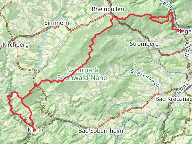
The Ausoniusweg is widely described as a 6-stage long-distance hike across the Hunsrück from Bingen to Trier. Common stage breaks include Bingen to Rheinböllen, then onward through Simmern and Kirchberg before the final approach to Trier, which helps split the 118.25 km route into manageable daily distances.
Where does the Ausoniusweg start, and how do hikers reach the trailhead?
The route starts in Bingen am Rhein, and Bingen Hauptbahnhof and Bingen Stadt are the main rail access points for the western end of the trail. A commonly used local stop for reaching the start is Drususbrücke in Bingerbrück, making public transport a practical option for beginning the walk.
What kind of terrain and difficulty should hikers expect on the Ausoniusweg?
The Ausoniusweg is rated medium difficulty and covers 118.25 km with about 2,163 meters of total ascent. The route follows the line of a Roman road and crosses vineyards, forest tracks, open Hunsrück landscapes, and sections near historic settlements, so it suits hikers with some multi-day experience.
Are there accommodations along the Ausoniusweg stages?
Yes. Because the Ausoniusweg is typically walked in stages through places such as Bingen, Rheinböllen, Simmern, Kirchberg, and Trier, overnight lodging is generally arranged in trail towns and villages rather than in remote mountain huts. That makes it practical to plan the route as a village-to-village multi-day walk.
What are the main highlights on the Ausoniusweg?
The Ausoniusweg links Bingen am Rhein with Trier and follows the historic line of the Roman Ausoniusstraße across the Hunsrück. Notable highlights mentioned along the route include stretches of the old Roman road corridor, the archaeology park at Belginum, and the Roman monumental sites in Trier.
Comments and Reviews
User comments, reviews and discussions about the Ausoniusweg, Germany.
5.0
average rating out of 5
4 rating(s)