Download
Preview
Add to list
More
12.8 km
~3 hrs 48 min
748 m
Loop
“Explore Sigmaringen's enchanting 13 km loop trail with stunning views, rich history, and diverse wildlife.”
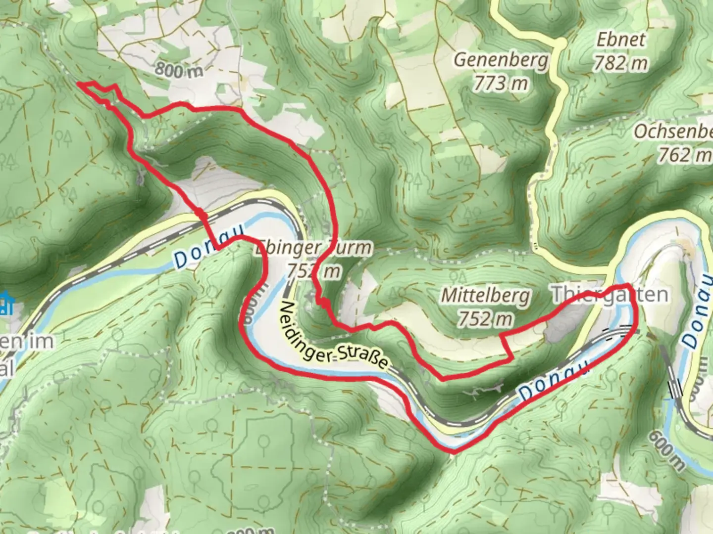
Starting near the picturesque town of Sigmaringen, Germany, the Ebinger and Donau via Schwaebische Alb Suedrand Weg is a captivating loop trail that spans approximately 13 kilometers (8 miles) with an elevation gain of around 700 meters (2,300 feet). This medium-difficulty trail offers a blend of natural beauty, historical landmarks, and diverse wildlife, making it a rewarding experience for hikers.
Getting There
To reach the trailhead, you can either drive or use public transport. If driving, head towards Sigmaringen, where ample parking is available near the starting point. For those using public transport, Sigmaringen is well-connected by train. From the Sigmaringen train station, you can take a local bus or taxi to the trailhead, which is conveniently located near the town center.
Trail Highlights
Initial Ascent and Forested Paths
The trail begins with a moderate ascent through dense forests, offering a serene environment filled with the sounds of chirping birds and rustling leaves. As you climb, you'll gain approximately 300 meters (1,000 feet) in elevation over the first 3 kilometers (1.9 miles). The forested paths are well-marked, but it's advisable to use the HiiKER app for navigation to ensure you stay on track.
Panoramic Views and Open Meadows
After the initial climb, the trail opens up to expansive meadows, providing panoramic views of the Swabian Alps. This section is relatively flat, allowing you to catch your breath and take in the stunning vistas. Around the 5-kilometer (3.1-mile) mark, you'll reach a viewpoint that offers a breathtaking panorama of the Danube River winding through the valley below.
Historical Landmarks
As you continue, you'll encounter several historical landmarks. One notable site is the ruins of Ebinger Castle, located approximately 7 kilometers (4.3 miles) into the hike. This medieval fortress, perched on a hilltop, offers a glimpse into the region's rich history. Take some time to explore the ruins and imagine the lives of those who once inhabited this stronghold.
Flora and Fauna
The trail is home to a diverse array of flora and fauna. In the spring and summer months, the meadows are adorned with wildflowers, attracting butterflies and bees. Keep an eye out for deer and foxes, which are commonly spotted in the area. Birdwatchers will also appreciate the variety of species that inhabit the forested sections of the trail.
Final Descent and Return
The final section of the trail involves a gradual descent back towards Sigmaringen. This part of the hike is less strenuous, allowing you to enjoy the surrounding scenery at a leisurely pace. As you approach the end of the loop, you'll pass through charming villages and farmland, offering a glimpse into rural life in the region.
Practical Tips
- Footwear: Sturdy hiking boots are recommended due to the varied terrain.
- Weather: Check the weather forecast before setting out, as conditions can change rapidly.
- Supplies: Carry sufficient water and snacks, especially during the warmer months.
- Navigation: Use the HiiKER app for real-time navigation and trail updates.
This trail offers a perfect blend of natural beauty, historical intrigue, and physical challenge, making it a must-visit for any hiking enthusiast exploring the Swabian Alps.

What to expect?
Activity types
Comments and Reviews
User comments, reviews and discussions about the Ebinger and Donau via Schwaebische Alb Suedrand Weg, Germany.
average rating out of 5
0 rating(s)