Download
3D Flyover
Add to list
More
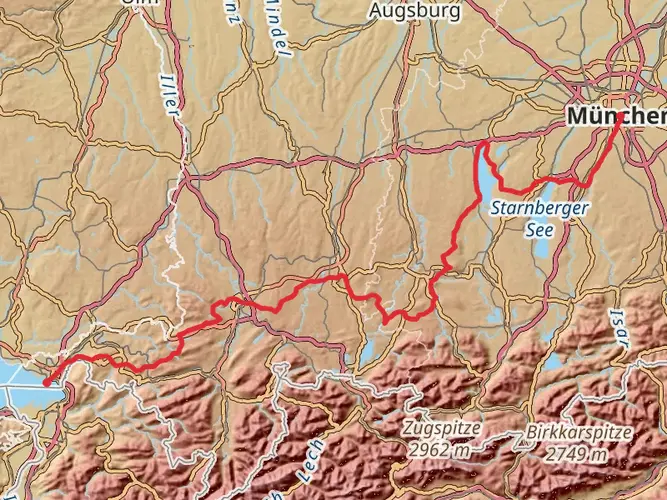
119.5 km
~5 days
1587 m
Multi-Day
“Embark on Germany's Heilige Landschaft Pfaffenwinkel - Ostschleife, a scenic 120km trail rich in culture and history.”
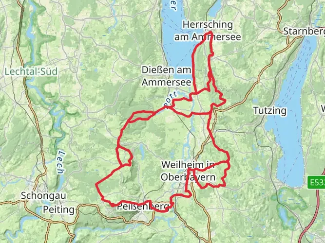
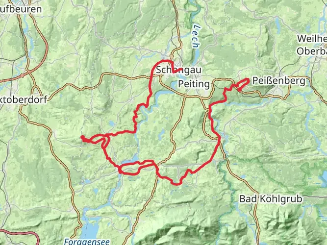
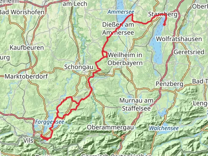
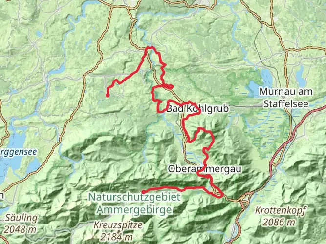
Embarking on the Heilige Landschaft Pfaffenwinkel - Ostschleife, hikers will traverse approximately 120 kilometers (about 75 miles) of varied terrain, with an elevation gain of around 1500 meters (nearly 4921 feet). This loop trail, nestled in the picturesque region of Weilheim-Schongau in Germany, offers a medium difficulty rating, making it accessible to hikers with a reasonable level of fitness.
Getting to the Trailhead
The journey begins near Weilheim-Schongau, where hikers can arrive at the trailhead by car or public transport. For those driving, parking is available in the vicinity of the starting point. Public transport users can take advantage of the regional train services to Weilheim in Oberbayern, followed by a short bus or taxi ride to the trailhead.
Navigating the Trail
Hikers can rely on the HiiKER app for detailed navigation throughout the trail, ensuring they stay on the right path and can anticipate what's ahead. The app provides real-time GPS tracking and offline maps, which are particularly useful in areas with limited mobile reception.
Landmarks and Scenery
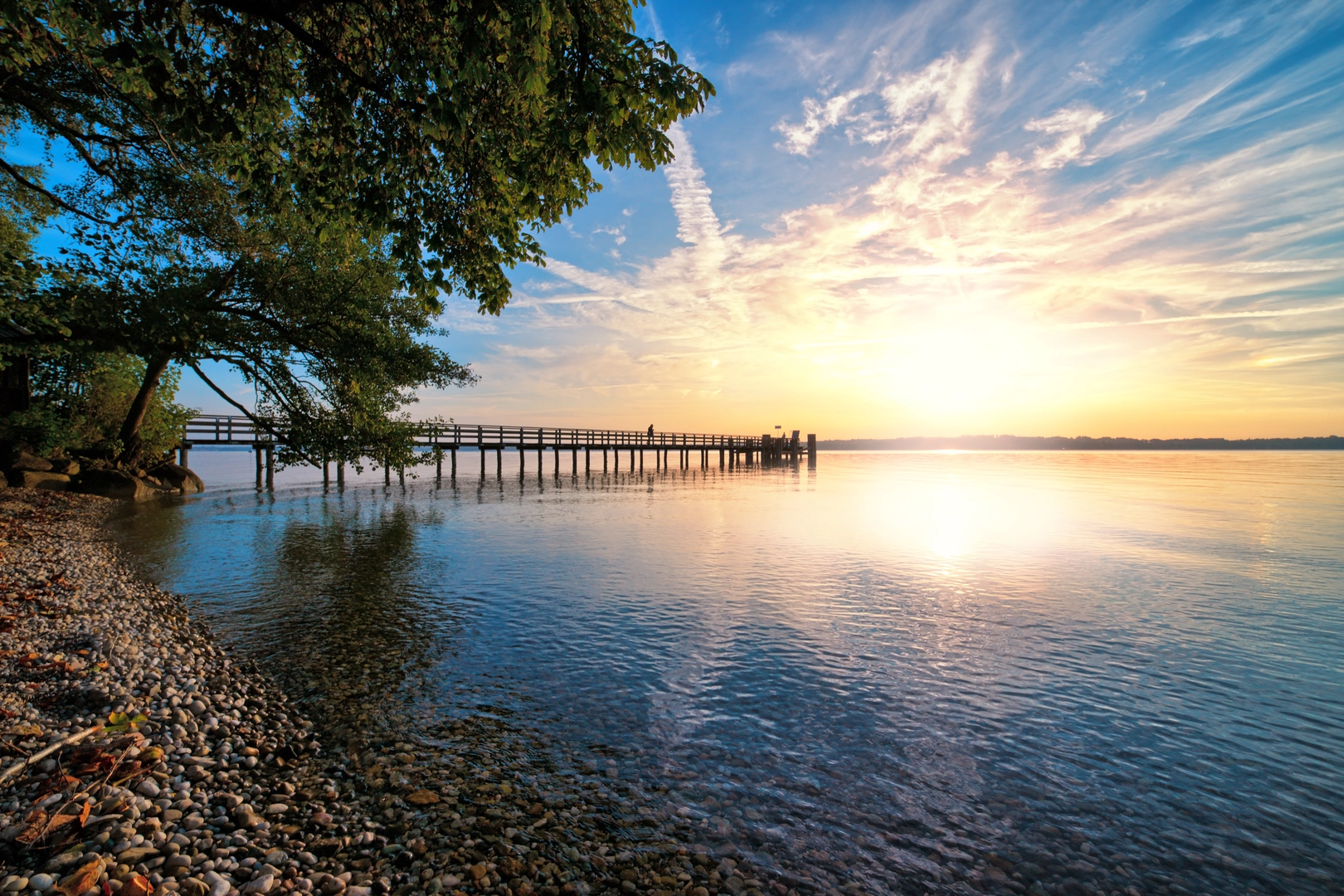
As you set out on the trail, you'll be greeted by the lush Bavarian countryside, dotted with rolling hills, serene lakes, and quaint villages. The trail meanders through the Pfaffenwinkel, an area renowned for its rich cultural heritage and an abundance of Rococo churches, which have significantly influenced the region's moniker, "Holy Landscape."
One of the architectural jewels encountered on this hike is the Wieskirche, a UNESCO World Heritage Site. This pilgrimage church, located approximately 28 kilometers (17 miles) from the trailhead, is a masterpiece of Rococo art with its ornate interior and frescoes.
Flora and Fauna
The region's natural beauty is complemented by its diverse flora and fauna. Hikers can expect to walk through forests of beech and spruce, open meadows, and along riverbanks. The changing seasons bring different highlights, from wildflowers in spring to the golden hues of autumn. Wildlife enthusiasts may spot deer, foxes, and a variety of bird species, including the majestic golden eagle.
Historical Significance
The Pfaffenwinkel region is steeped in history, with its landscape shaped by centuries of agricultural use and religious significance. The trail offers a glimpse into the past, with opportunities to visit ancient ruins, historic towns, and monuments that tell the story of the area's development over time.
Preparation and Planning
Before setting out, hikers should ensure they are well-prepared with appropriate gear, including sturdy footwear, weather-appropriate clothing, and sufficient water and food supplies. The trail includes several segments with no immediate access to amenities, so carrying essentials is crucial.
Conclusion
The Heilige Landschaft Pfaffenwinkel - Ostschleife is a trail that offers a blend of natural beauty, cultural experiences, and historical exploration. With careful planning and a spirit of adventure, hikers will find this trail to be a rewarding journey through one of Germany's most enchanting landscapes.

Frequently asked questions
How long does the Heilige Landschaft Pfaffenwinkel - Ostschleife take to hike?
The Heilige Landschaft Pfaffenwinkel - Ostschleife is a 119.51 km multi-day loop, so most hikers break it into about 8 days of walking. That works out to roughly 15 km per day, which fits the route’s medium difficulty and total elevation gain of 1,587 m.
Where does the Heilige Landschaft Pfaffenwinkel - Ostschleife start and finish?
The Heilige Landschaft Pfaffenwinkel - Ostschleife is a loop in the Pfaffenwinkel region, and the staged route begins and ends at Hohenpeißenberg in Weilheim-Schongau. Because it is circular, the same trailhead serves as both the starting point and the finish.
Is the Heilige Landschaft Pfaffenwinkel - Ostschleife a hard hike?
The Heilige Landschaft Pfaffenwinkel - Ostschleife is rated medium rather than hard, but it is still a serious long-distance walk. The challenge comes from covering 119.51 km over several days and climbing a total of 1,587 m, not from highly technical mountain terrain.
What kind of scenery is on the Heilige Landschaft Pfaffenwinkel - Ostschleife?
The Heilige Landschaft Pfaffenwinkel - Ostschleife is the “Spiegelnde Wasser” loop within the Heilige Landschaft Pfaffenwinkel network, and it is known for water-rich scenery. The route passes through the Bavarian countryside around the Starnberger See area, the Osterseen landscape, and a series of lakes, ponds, monasteries, and church villages in the Pfaffenwinkel.
Is there a map for the Heilige Landschaft Pfaffenwinkel - Ostschleife?
Yes. The Heilige Landschaft Pfaffenwinkel - Ostschleife is mapped as a staged long-distance route, and the full loop is about 119.51 km. Because it is a multi-day circuit with several daily sections, a stage-by-stage map is the most practical way to follow the route from Hohenpeißenberg around the eastern loop and back.
Can you reach the Heilige Landschaft Pfaffenwinkel - Ostschleife by public transport?
Yes. The Heilige Landschaft Pfaffenwinkel - Ostschleife is commonly approached from Weilheim in Oberbayern by regional rail, with onward local transport toward Hohenpeißenberg. That makes it possible to reach the loop without a car, although the exact final connection depends on the day’s local bus and train schedules.
Is the Heilige Landschaft Pfaffenwinkel - Ostschleife part of the Jakobsweg or the Wildganz Pilgerweg?
The Heilige Landschaft Pfaffenwinkel - Ostschleife is part of the Heilige Landschaft Pfaffenwinkel pilgrimage network, which includes three multi-day loops: Ostschleife, Westschleife, and Nordschleife. It is a pilgrimage route in its own right rather than simply another name for the Jakobsweg, although the wider Pfaffenwinkel region is also associated with pilgrimage walking and sections that connect with other historic routes.
Comments and Reviews
User comments, reviews and discussions about the Heilige Landschaft Pfaffenwinkel - Ostschleife, Germany.
4.45
average rating out of 5
11 rating(s)