Download
3D Flyover
Add to list
More
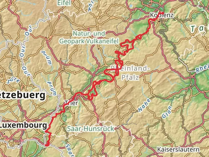
114.3 km
~5 days
2791 m
Multi-Day
“Traverse the Mosel-Our-Weg's vineyard-clad hills, historical landmarks, and diverse terrains for a medium-difficulty German hiking adventure.”
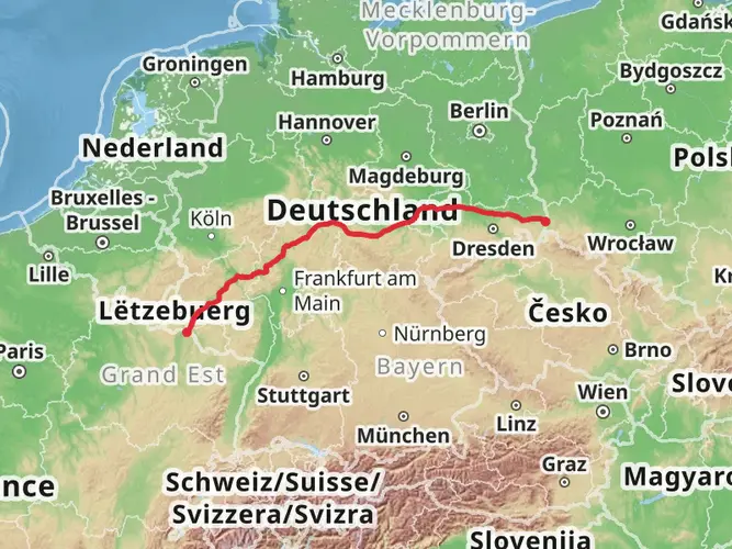
Embarking on the Mosel-Our-Weg, hikers will traverse approximately 114 kilometers (about 71 miles) of varied terrain, with an elevation gain of around 2700 meters (approximately 8858 feet). This point-to-point trail begins near the quaint town of Zell, situated on the banks of the Mosel River in Germany, and is considered to have a medium difficulty rating.
Getting to the Trailhead
To reach the starting point near Zell, hikers can opt for public transportation or personal vehicles. The nearest major city with a train station is Koblenz, from where you can take a regional train to Bullay and then a connecting bus to Zell. If driving, Zell is accessible via the B53 road that follows the course of the Mosel River. Parking is available in the town, and from there, the trailhead is easily accessible.
Navigating the Trail
The Mosel-Our-Weg is well-marked, with clear signage guiding hikers through the picturesque landscapes. For additional navigation support, the HiiKER app provides detailed maps and GPS coordinates to ensure you stay on the right path.
Trail Highlights and Landmarks
As you set out from the vicinity of Zell, the trail meanders through lush vineyards, a testament to the region's rich wine-making heritage. The Mosel Valley is renowned for its Riesling, and hikers will have the opportunity to witness the terraced vineyards that are characteristic of the area.
The trail offers panoramic views of the Mosel River, with opportunities to spot local wildlife, including a variety of bird species. The path leads through deciduous forests and open fields, with the changing seasons painting a vibrant backdrop.
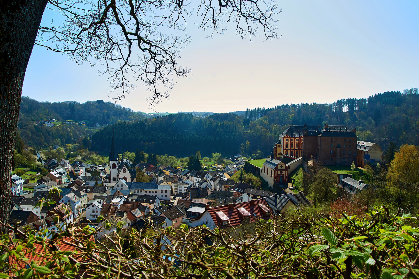
Historical significance is woven into the landscape, with castles and ruins dotting the hillsides, including the imposing Cochem Castle, which is a highlight for many. The trail also passes through charming villages where hikers can experience local culture and hospitality.
Elevation and Terrain
The Mosel-Our-Weg is characterized by its rolling hills, with some steep ascents and descents. The elevation gain is spread out across the trail, but there are sections that will require a good level of fitness. The terrain varies from paved paths to rugged, natural trails, so appropriate footwear is essential.
Preparation and Planning
Before embarking on the hike, ensure you have adequate supplies, including water, snacks, and a first-aid kit. Weather in the region can be unpredictable, so layered clothing and waterproof gear are recommended. Plan your accommodations in advance, as the trail can take several days to complete, with options ranging from campgrounds to guesthouses in the villages along the route.
Conservation and Etiquette
The Mosel-Our-Weg travels through sensitive ecosystems and cultural sites. Hikers are encouraged to practice Leave No Trace principles, respecting wildlife and maintaining the pristine condition of the trail for future visitors.
By preparing adequately and respecting the natural and historical significance of the Mosel-Our-Weg, hikers will have an enriching experience exploring one of Germany's most scenic and culturally rich regions.

Frequently asked questions
How long does the Mosel-Our-Weg take to hike from the Zell area to Vianden?
The Mosel-Our-Weg is about 114.33 km long, so most hikers break it into roughly 5 to 7 days. The route is commonly described in 6 stages, which fits the trail’s medium difficulty and its total elevation gain of about 2,791 meters.
Where does the Mosel-Our-Weg start and finish?
The Mosel-Our-Weg runs from the Mosel valley near Alf and the Zell (Mosel) area to Vianden in Luxembourg. The full route is generally listed at about 115 km, ending near Vianden after crossing the Eifel uplands and reaching the Our valley.
Is the Mosel-Our-Weg a difficult long-distance hike?
The Mosel-Our-Weg is usually rated medium rather than hard, but it is still a demanding multi-day walk. Over 114.33 km, the route gains about 2,791 meters, so the main challenge is the repeated climbing and descending between river valleys, wooded ridges, and upland sections.
Can the Mosel-Our-Weg be done in stages?
Yes. The Mosel-Our-Weg is a multi-day point-to-point trail and is commonly split into 6 stages. That stage format makes sense for a route of just over 114 km, especially with steady elevation gain and a finish in Vianden rather than a loop back to the start.
How do hikers get to the Mosel-Our-Weg from Zell (Mosel) by public transportation?
For the Zell (Mosel) side of the Mosel-Our-Weg, the usual rail access is Bullay station, followed by a regional bus connection into Zell. Current bus timetables show service between Bullay Bahnhof and Zell (Mosel), which makes the Mosel valley end practical to reach without a car.
Where can hikers park for the Mosel-Our-Weg near Zell (Mosel)?
Parking for the Mosel-Our-Weg near Zell is available in the town, but Zell’s parking rules changed in 2025. The old town area between the port and Zell church is reserved for resident parking, while other signed town parking areas and the MoselPark Zell area are the better options for trail access.
What kind of scenery does the Mosel-Our-Weg pass through?
The Mosel-Our-Weg links two river landscapes, starting in the Mosel wine region and finishing in the Our valley at Vianden. Along the way it passes vineyard country, forested Eifel ridges, volcanic uplands around places such as Manderscheid and the Mosenberg area, and a final stretch toward the Our reservoir and Vianden.
Is the Mosel-Our-Weg waymarked?
Yes. The Mosel-Our-Weg is one of the Eifelverein’s main long-distance hiking routes and is waymarked with the association’s three-color “E” symbol and the route name. That established marking system is used across the full route from the Mosel side to Vianden.
Comments and Reviews
User comments, reviews and discussions about the Mosel-Our-Weg, Germany.
4.63
average rating out of 5
8 rating(s)