Download
3D Flyover
Add to list
More
1011.2 km
~39 days
17974 m
Multi-Day
“From rugged Atlantic shores to wild northern cliffs, this trail weaves Ireland’s spirit into every step.”
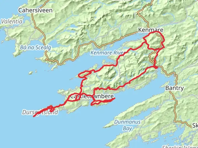
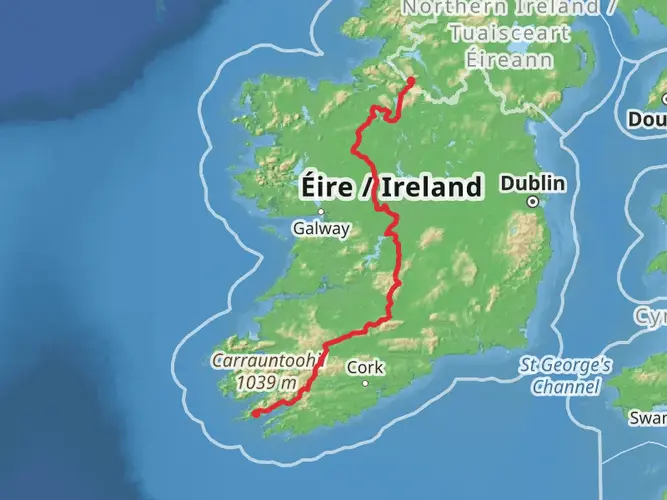
Starting near Castletownbere in County Cork, the journey across Ireland on this 1,011 km (628 mile) point-to-point trail is a true immersion into the heart of the island. With a total elevation gain of approximately 18,000 metres (59,000 feet), the route is a blend of rolling hills, rugged mountains, tranquil valleys, and vibrant towns, offering a medium-level challenge suitable for experienced walkers with good fitness.
Getting There
The trailhead is located near Castletownbere, a bustling fishing port on the Beara Peninsula. To reach Castletownbere, take a train or bus from Dublin or Cork to Kenmare or Bantry, then transfer to a local bus or taxi for the final stretch. For those driving, parking is available in Castletownbere, but arranging transport back from the finish is essential due to the point-to-point nature of the route.
Route Overview and Navigation
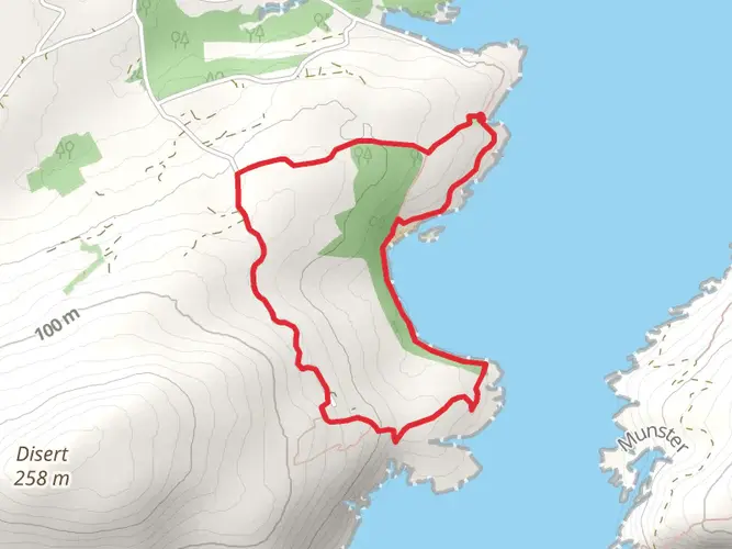
The Ireland Way® weaves together several established trails, including the Beara Way, the Ballyhoura Way, the Shannon Erne Trail, and the Ulster Way, among others. Navigation is straightforward with the HiiKER app, which provides up-to-date maps, waypoints, and offline navigation—essential for remote sections where signage may be sparse.
Landscapes and Elevation
Expect a dramatic variety of landscapes. The Beara Peninsula greets you with rugged Atlantic coastline, ancient stone circles, and the Caha Mountains, where the first major climbs begin. The route then heads inland, traversing the lush valleys and forests of County Cork and Limerick, with rolling farmland and quiet villages offering a gentler pace.
As you approach the Galtee Mountains, the highest inland range in Ireland, prepare for steep ascents and panoramic views. The trail continues through the Golden Vale, famed for its fertile farmland, before reaching the River Shannon, Ireland’s longest river. Crossing into the midlands, the terrain flattens, with peat bogs, lakes, and open countryside dominating the landscape.
Northern sections bring you into the Sperrin Mountains and the wilds of County Antrim, with heather-clad hills and remote moorland. The final stretch leads to Ballycastle on the north coast, where the Atlantic winds and dramatic cliffs provide a fitting end.
Significant Landmarks and Historical Sites
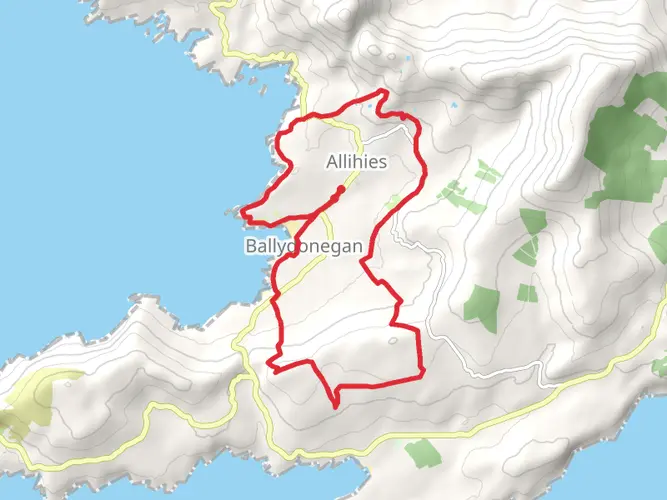
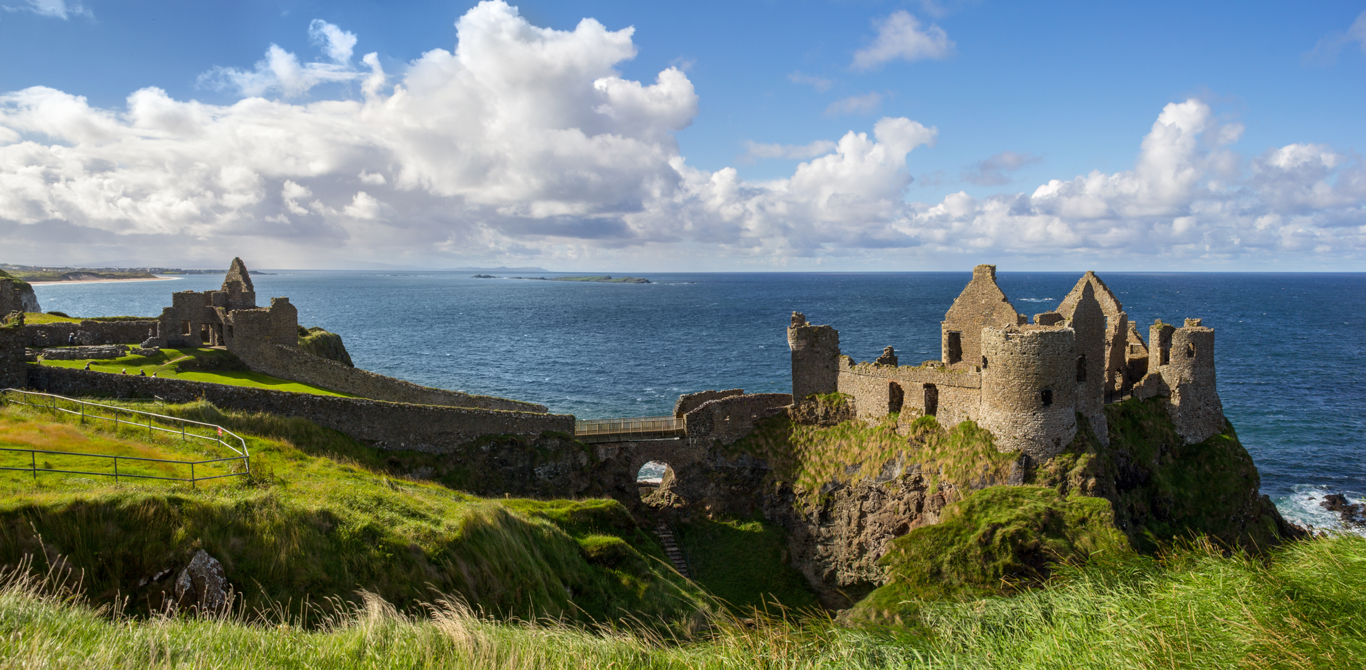
- Beara Peninsula: Ancient stone circles, Dunboy Castle, and the colorful town of Allihies.
- Gougane Barra: A serene lake and forest park, home to St. Finbarr’s Oratory.
- Lough Gur: A prehistoric site with stone circles and archaeological remains.
- River Shannon: Historic towns like Limerick and Carrick-on-Shannon, with medieval castles and riverside walks.
- Ulster Way: Carrick-a-Rede Rope Bridge, Giant’s Causeway (a UNESCO World Heritage Site), and the Glens of Antrim.
Wildlife and Nature
Ireland’s temperate climate supports a rich variety of flora and fauna. Along the trail, look for red deer in the forests, otters and herons along rivers, and seabirds on the northern coast. Spring and summer bring wildflowers to the meadows and hedgerows, while autumn colors transform the woodlands.
Accommodation and Resupply
Towns and villages are spaced at regular intervals, typically every 20–30 km (12–19 miles), offering B&Bs, hostels, and small hotels. Wild camping is possible in remote areas, but always seek landowner permission. Shops and cafes are plentiful in larger towns, but some rural stretches require carrying extra food and water.
Weather and Preparation
Irish weather is famously changeable. Waterproof clothing, sturdy boots, and layered clothing are essential year-round. The trail can be muddy after rain, especially in upland and boggy sections. Summer offers the longest daylight hours, but spring and autumn are quieter and equally beautiful.
Transport and Logistics
Public transport options are available at major towns along the route, but rural sections may require advance planning for taxis or local buses. The HiiKER app can help identify nearby transport links and accommodation options.
This route is a journey through Ireland’s natural beauty, history, and culture, rewarding those who take the time to explore its length with unforgettable experiences and ever-changing scenery.

What to expect?
Activity types
Frequently asked questions
How long is The Ireland Way® and where does The Ireland Way® start and finish?
The Ireland Way® is 1,011.21 km long, or about 628 miles. It is a point-to-point trail that starts near Castletownbere on the Beara Peninsula in County Cork and finishes at Ballycastle on the north coast, with the overall route linking the Beara-Breifne Way and the Ulster Way.
How many days does it take to walk The Ireland Way®?
A full thru-hike of The Ireland Way® is commonly planned at around 40 days, although the exact schedule depends on daily mileage, weather, and rest days. At 1,011.21 km with 17,974 m of climbing, it is a serious long-distance walk rather than a short section hike.
Is The Ireland Way® difficult to walk?
The Ireland Way® is generally rated medium difficulty, but its scale makes it a demanding undertaking. The route covers 1,011.21 km with 17,974 m of ascent, so the challenge comes from sustained back-to-back days, changing terrain, and long remote stretches as much as from any single climb.
What trails make up The Ireland Way®?
The Ireland Way® is built by joining the Beara-Breifne Way in the south with the Ulster Way in the north. Along the route it includes established sections such as the Beara Way, Ballyhoura Way, Shannon Erne Way, and the western and northern parts of the Ulster Way.
What is the first section of The Ireland Way® like near Castletownbere?
The opening section from the Castletownbere area heads into the Beara Peninsula landscape of Atlantic coast, old stone sites, and mountain country. Early days on the route use the Beara Way and bring walkers into the Caha Mountains before the trail turns inland toward the long cross-country journey north.
Are there any remote sections on The Ireland Way® where planning matters more?
Yes. Northern sections of The Ireland Way® can be harder to organize day by day, especially after the route joins the Ulster Way. Accommodation is noted as sparse in parts of Northern Ireland, particularly across stages 13 to 18, so those stretches usually need more careful distance and overnight planning.
Comments and Reviews
User comments, reviews and discussions about the The Ireland Way®, Ireland.
4.84
average rating out of 5
63 rating(s)