Download
3D Flyover
Add to list
More
26.0 km
~6 hrs 43 min
913 m
Multi-Day
“Embark on the Stradbally Mountain Loop for an immersive hike through Kerry's diverse landscapes and rich history.”
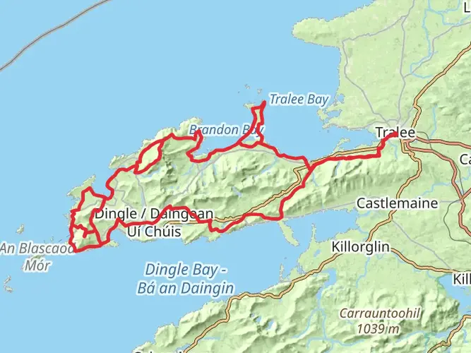
The Stradbally Mountain Loop is a captivating trail that takes you through the diverse landscapes of County Kerry, Ireland. Spanning approximately 26 kilometers (about 16 miles) with an elevation gain of around 900 meters (nearly 2953 feet), this loop offers a medium difficulty level, making it accessible to hikers with a reasonable level of fitness.
Getting to the Trailhead
To reach the trailhead, which is situated near the town of Stradbally, you can drive or take public transport. If driving, you can navigate to the nearby town of Castlegregory, which is well-signposted and accessible from major roads in the region. From Castlegregory, follow the local road signs towards Stradbally. Parking is available in the vicinity of the trailhead.
For those opting for public transport, buses serve the nearby towns from larger cities such as Tralee and Killarney. From these towns, you may need to take a taxi to the trailhead, as direct bus services may not be available.
Navigating the Trail
As you embark on the Stradbally Mountain Loop, you'll find that the trail is well-marked, but carrying a map or using a navigation tool like HiiKER is recommended to keep track of your progress and ensure you stay on the correct path.
Landmarks and Scenery
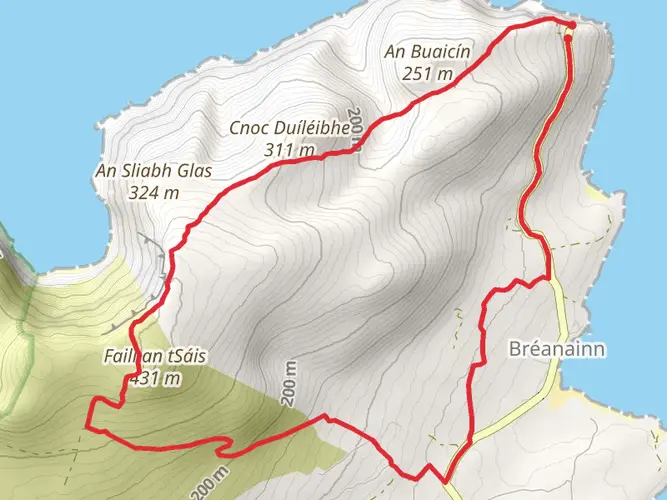
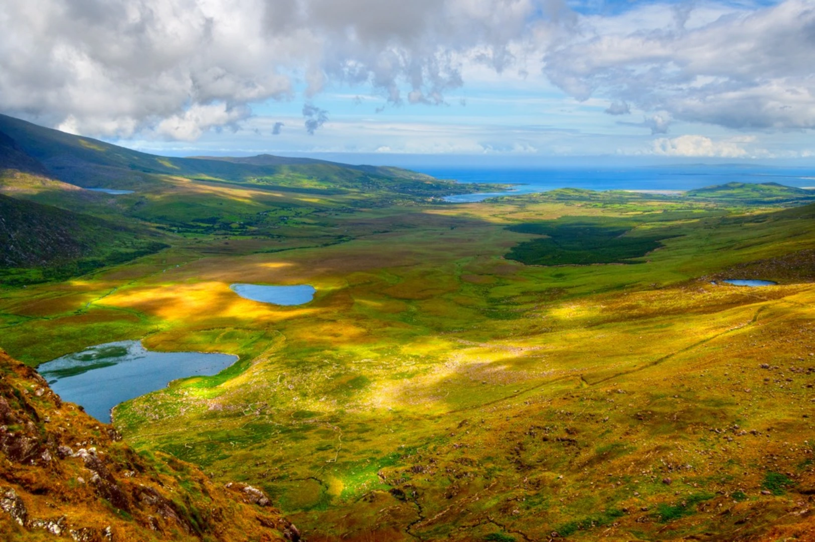
The trail begins with a gradual ascent, winding through lush greenery and open farmland. As you climb, the views of the Atlantic Ocean and the surrounding countryside become increasingly spectacular. Approximately 5 kilometers (3.1 miles) in, you'll reach the first significant elevation gain, where the landscape transitions to rugged heathland.
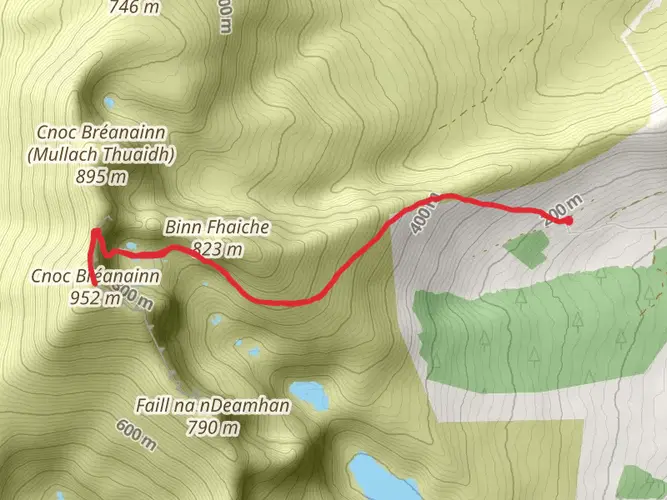
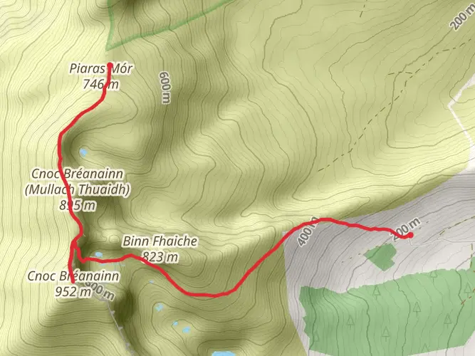
Continuing on, you'll encounter the Beenoskee and Stradbally Mountain peaks. These areas offer breathtaking panoramic views of the Dingle Peninsula, Brandon Bay, and the Maharees Islands. The trail does not summit these peaks but skirts around them, providing ample opportunities to enjoy the vistas.
Flora and Fauna
The region is rich in biodiversity, with a variety of plant life that changes with the elevation. Lower down, you'll see a mix of ferns, gorse, and heather, while higher up, the vegetation becomes more sparse. Wildlife enthusiasts may spot native birds such as the peregrine falcon and the Irish hare.
Historical Significance
The Dingle Peninsula is steeped in history, with ancient sites dotted throughout the landscape. While the Stradbally Mountain Loop does not pass directly by these historical landmarks, the area is known for its early Christian and pre-Christian structures, such as Ogham stones, ring forts, and beehive huts.
Preparing for the Hike
Before setting out, ensure you're prepared with appropriate hiking gear, including waterproof clothing, as the weather can be unpredictable. Bring plenty of water, snacks, and a first-aid kit. It's also wise to inform someone of your hiking plans and expected return time.
Conclusion
The Stradbally Mountain Loop is a trail that offers a little bit of everything: challenging climbs, stunning views, and a touch of the rich cultural heritage of County Kerry. Whether you're a seasoned hiker or someone looking to immerse yourself in the beauty of Ireland's landscapes, this trail promises a rewarding experience.

What to expect?
Activity types
Frequently asked questions
How long does the Stradbally Mountain Loop take to hike?
The Stradbally Mountain Loop is 26.02 km long with 913 m of climbing, so it is usually treated as a two-day hike rather than a short day walk. HiiKER lists the route as multi-day, and the combination of distance and elevation means a full single-day push is better suited to strong, experienced hikers.
Is the Stradbally Mountain Loop difficult?
The Stradbally Mountain Loop is rated medium, but it is still a substantial outing at 26.02 km with 913 m of elevation gain. That makes it a good fit for hikers with solid fitness who are comfortable covering a long distance over a full day or splitting the route across two days.
Where do you start the Stradbally Mountain Loop and is there parking nearby?
The route starts near Stradbally in County Kerry, on the Dingle Peninsula. Parking is available in the vicinity of the trailhead near Stradbally, and drivers commonly approach via Castlegregory before following local roads toward the start of the loop.
Can you reach the Stradbally Mountain Loop by public transport?
Public transport is possible, but it is not usually a simple trailhead-to-trailhead trip. Transport for Ireland's Local Link Route 273 serves Stradbally and connects the area with Castlegregory and Tralee, so the most practical option is usually to travel into the peninsula first and then continue to the start near Stradbally.
Is the Stradbally Mountain Loop dog friendly?
The Stradbally Mountain Loop is listed as dog-friendly on HiiKER. Because this is a long mountain route that passes through mixed rural and upland terrain, dogs should be kept under close control, especially anywhere livestock may be present along the loop.
Is the Stradbally Mountain Loop a loop trail or an out-and-back?
The Stradbally Mountain Loop is a loop trail, so it starts and finishes in the same general area near Stradbally. That makes logistics easier than a point-to-point hike, especially for anyone arriving by car and leaving a vehicle near the trailhead.
Comments and Reviews
User comments, reviews and discussions about the Stradbally Mountain Loop, Ireland.
4.6
average rating out of 5
30 rating(s)