Download
Preview
Add to list
More
8.6 km
~1 hrs 51 min
82 m
Loop
“A gentle figure-eight through cool woods opens to sunlit fossil shores beneath Calvert’s pale bluffs—conditions permitting.”
This easy coastal loop/figure-eight style walk covers about 9 km (5.6 mi) with roughly 100 m (330 ft) of total climbing, mostly in short, gentle rises on forested park trails. The big payoff is the stretch along the base of the cliffs and beach where you’ll see the famous pale bluffs, shell beds, and—if conditions are right—fossil-bearing sediments.
Getting to the trailhead (car + public transport)
By car: The most common and practical start is at Calvert Cliffs State Park, near Lusby, Maryland. Use the park entrance off MD-2/4 (Solomons Island Road) and follow signs to the main day-use parking area for the Red Trail/Cliffs access. A good “nearest landmark” to orient around is Calvert Cliffs State Park (Lusby, MD 20657)—that’s the place most hikers mean when they reference this route.
By public transport: Transit is limited in this part of Calvert County. The most workable approach is typically: - MARC/Amtrak to Washington, DC (or to a closer hub if you’re already in Maryland), - then a regional bus toward Prince Frederick/Solomons (service varies by operator and schedule), - and finally a rideshare/taxi to Calvert Cliffs State Park. Because schedules and routes can change, check the current Calvert County/region bus timetables before committing to a car-free plan.
What the route feels like (Blue + Orange Trails)
From the day-use area, you’ll settle into shaded woodland walking on packed dirt with occasional roots. The first part is typically the “warm-up” section: gradual, low-effort undulations rather than sustained climbs. Over the full hike you’ll accumulate about 100 m (330 ft) of gain, but it’s spread out enough that it rarely feels like “hill work.”
At around 2–3 km (1.2–1.9 mi) in, you’ll start noticing the landscape subtly changing—more openings, a brighter understory, and the sense that you’re trending toward the coastal plain edge. Expect a few short, slightly steeper pitches where rain can carve shallow ruts; after wet weather, these can be slick with leaf litter.
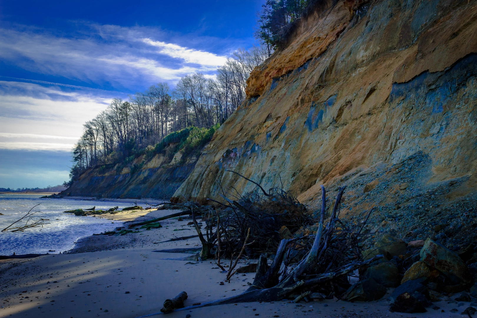
Cliffs, beach walking, and fossil country
The signature section is the approach to the cliffline and shoreline. The cliffs here are part of the Chesapeake Group exposures—Miocene-era marine sediments that made Calvert County internationally known for fossils. The region’s history is deeply tied to these deposits: the cliffs preserve evidence of ancient seas and the marine life that once thrived here, and the broader Chesapeake Bay area has long been a corridor for Indigenous communities and later colonial settlement and maritime trade.
On the beach segment, footing changes to sand, pebbles, and occasional driftwood tangles. This is where you’ll want to slow down and scan the ground—shell fragments are common, and fossil material can occur in the eroded sediments. Conditions vary a lot with: - Tide level (higher water can narrow the passable beach), - Recent storms (which can expose fresh material but also leave debris), - Cliff stability (see safety notes below).
Plan for the most “open” feeling of the hike here: more sun, more wind, and fewer places to hide from weather.
Landmarks, nature, and wildlife to watch for
- Coastal forest and wetlands: The inland portions often pass through mixed hardwoods and low, damp areas where you’ll hear frogs and see seasonal wildflowers.
- Birdlife: Expect osprey and bald eagles overhead near the Bay, plus gulls and shorebirds along the beach. Spring and fall can be especially active for migration.
- Deer and small mammals: White-tailed deer are common; you may also spot foxes or raccoons closer to dawn/dusk.
- Insects: In warm months, mosquitoes and ticks can be significant in shaded, humid sections—long socks and repellent help.
Safety and “look out for” items
- Cliff-fall hazard: Avoid lingering directly under the cliffs. Erosion can cause sudden slumps, especially after heavy rain or freeze-thaw cycles.
- Tides and beach pinch points: If the beach narrows, don’t force a risky pass close to the waterline. Time your hike for a safer tide window when possible.
- After-rain traction: Roots + wet leaves can be slick on the wooded trails; take care on short descents.
- Heat exposure: The beach/cliff section can feel much hotter than the forest. Bring more water than you think you’ll need for a 9 km (5.6 mi) outing, especially in summer.
Navigation and planning notes (HiiKER)
Trail junctions can come up quickly in the woods, and color blazes can be easy to miss when leaves are down or when multiple paths intersect. Use HiiKER to: - confirm you’re on the correct Blue and Orange segments, - anticipate junctions before you reach them, - and keep an eye on distance so you can pace breaks around the beach/cliff portion.
What to pack for an easy 9 km (5.6 mi) day
- Footwear: Trail shoes with decent grip handle the mix of dirt, roots, and sand well.
- Water + sun protection: Especially for the exposed shoreline.
- Bug/tick protection: Particularly late spring through early fall.
- **A small

Surfaces
Ground
Wood
Unknown
Comments and Reviews
User comments, reviews and discussions about the Calvert Cliffs via Blue Trail and Orange Trail, Maryland.
average rating out of 5
0 rating(s)