Download
Preview
Add to list
More
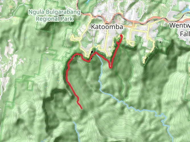
23.4 km
~2 days
1235 m
Multi-Day
“Embark on a challenging 23km hike through the Blue Mountains' splendid vistas, steep terrain, and rich heritage.”
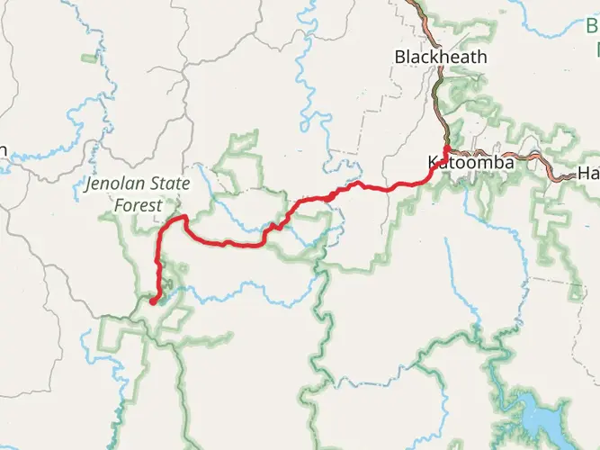
Embarking on the Victoria Falls and Grose Valley trail, hikers will traverse approximately 23 kilometers (around 14.3 miles) with an elevation gain of roughly 1200 meters (close to 3937 feet), showcasing the rugged beauty of the Blue Mountains in New South Wales. This point-to-point trail is considered difficult due to its steep descents and ascents, technical terrain, and the level of fitness required.
Getting to the Trailhead
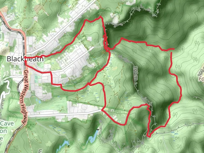
The journey begins near the town of Blackheath, accessible by car or public transport. For those driving, parking is available at the end of Victoria Falls Road, which is the nearest known address to the trailhead. Public transport users can take a train to Blackheath Station and then a taxi or a local bus to the starting point.
The Trail Experience
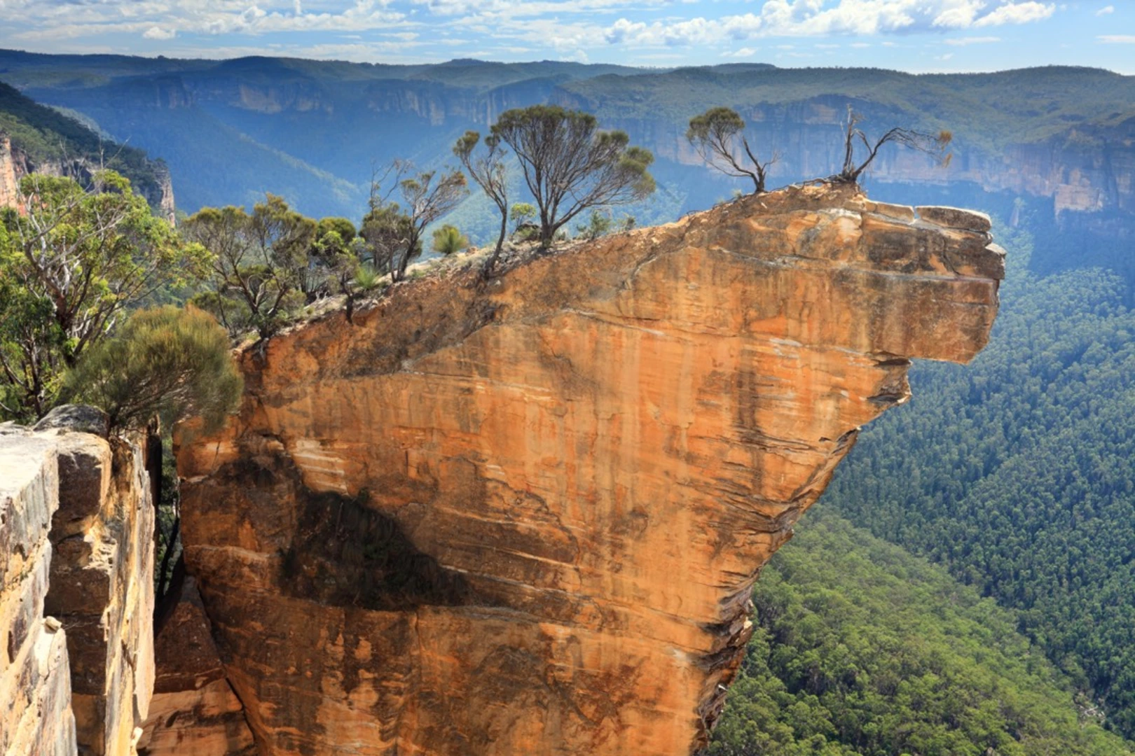
As hikers set out from the trailhead, they will be greeted by the mesmerizing Victoria Falls, a cascade that plummets into the valley below. The initial descent is steep and can be slippery, so caution is advised. After enjoying the falls, the trail continues along the escarpment, offering panoramic views of the Grose Valley and its surrounding cliffs.
Flora and Fauna
The path winds through diverse ecosystems, including eucalyptus forests, heathlands, and rainforest pockets, providing opportunities to observe a variety of bird species, such as cockatoos and lyrebirds. The spring months bring a colorful display of wildflowers, including waratahs and orchids.
Historical Significance
The Blue Mountains region holds great historical and cultural significance. It was a formidable barrier to early European settlers and is rich in Aboriginal heritage. The Grose Valley itself was named after Lieutenant William Grose and has been an inspiration for artists and nature enthusiasts for centuries.
Navigating the Trail
Hikers should be well-prepared with a map and compass, and it's recommended to use the HiiKER app for up-to-date trail information and navigation. The trail is marked, but some sections can be less distinct, so careful navigation is essential.
Preparing for the Hike
Due to the trail's difficulty, it's important to carry sufficient water, at least 2 to 3 liters per person, and high-energy snacks. Weather in the Blue Mountains can change rapidly, so layered clothing and rain gear are advisable. Sturdy hiking boots with good ankle support are a must to handle the rocky and uneven terrain.
Safety Considerations
Mobile reception can be unreliable, so hikers should inform someone of their plans and expected return time. It's also wise to carry a first aid kit and a personal locator beacon (PLB) in case of emergencies.
End of the Trail
The endpoint of the trail is at the junction with the Blue Gum Forest track, a significant landmark in the conservation history of the Blue Mountains. From here, hikers can continue exploring or arrange for pick-up to return to Blackheath.

What to expect?
Activity types
Frequently asked questions
How hard is the Victoria Falls and Grose Valley hike in the Blue Mountains?
Victoria Falls and Grose Valley is an Extra Difficult multi-day hike covering 23.38 km with 1,235 m of elevation gain. The route involves steep descents into the Grose Valley and a demanding climb back out, so it suits experienced hikers with strong fitness and comfort on rough, technical terrain.
Where do you start the Victoria Falls and Grose Valley hike and is there parking?
The usual start is at the Victoria Falls walking track trailhead in the Blackheath area of Blue Mountains National Park. Parking is available at the end of Victoria Falls Road, which is the main access point for Victoria Falls and the upper Grose Valley route.
Can you reach the Victoria Falls and Grose Valley hike by public transport?
Yes. Regular Blue Mountains Line trains stop at Blackheath Station, and NSW National Parks lists public transport access for the Victoria Falls walking track area. From Blackheath, the trailhead is reached by road toward Victoria Falls Road, so the final leg normally requires a taxi or local transfer.
Can you camp on the Victoria Falls and Grose Valley hike?
Yes, but camping is limited to designated remote campgrounds in the Upper Grose Valley. NSW National Parks directs overnight walkers on the Victoria Falls route to places such as Burra Korain campground and Acacia Flat campground rather than informal camps beside the track.
Are dogs allowed on the Victoria Falls and Grose Valley hike?
Dogs are generally not allowed on walking tracks in Blue Mountains National Park, including the Victoria Falls area. NSW national park pet policy only permits dogs in selected regional park locations, so this Grose Valley route should be treated as not dog-friendly unless a specific exception applies.
What will you see on the Victoria Falls and Grose Valley hike?
The route passes Victoria Falls early on, then drops into the Grose Valley through rugged bushland and cliff-lined country. The official park map for the Victoria Falls walking track also names features including Victoria Creek, Asgard Brook, Silver Cascades, Fenris Gully, and Odin Gully along this section of the landscape.
How long does the Victoria Falls and Grose Valley hike take?
Victoria Falls and Grose Valley is best planned as a multi-day hike rather than a short day walk. At 23.38 km with 1,235 m of climbing, the combination of distance, steep valley access, and rough Blue Mountains terrain makes it a substantial overnight route for most hikers.
Comments and Reviews
User comments, reviews and discussions about the Victoria Falls and Grose Valley, New South Wales.
4.75
average rating out of 5
8 rating(s)