Download
3D Flyover
Add to list
More
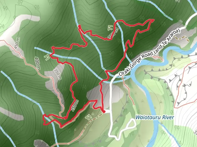
37.8 km
~2 days
2448 m
Multi-Day
“Embark on the Tararua Southern Crossing, a stunning yet demanding odyssey through New Zealand's wild heart.”
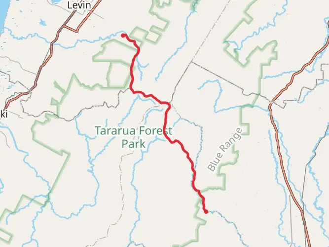
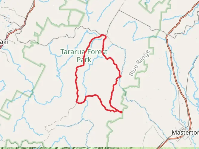
The Tararua Southern Crossing is a challenging and rewarding point-to-point trek spanning approximately 38 kilometers (about 23.6 miles) with an elevation gain of around 2400 meters (roughly 7874 feet). This trail, nestled in the Tararua Range near Carterton, New Zealand, is not for the faint-hearted and is best suited for experienced hikers due to its difficult terrain and unpredictable weather conditions.
Getting to the Trailhead
To reach the trailhead, which is situated near Carterton, hikers can drive or take public transportation to the vicinity of the Kaitoke Regional Park, which serves as the northern entrance to the trail. For those relying on public transport, regional bus services can drop you near the park entrance, from where you can begin your trek. If driving, parking is available at the park entrance, allowing for a convenient start to your journey.
Trail Overview
The journey commences with a gradual ascent through lush native forest, where the sounds of local birdlife, such as the melodious tui and the cheeky kaka, accompany hikers. The trail then leads to the first significant landmark, the Alpha Hut, which is roughly 11 kilometers (about 6.8 miles) from the start. This is a good spot to rest and take in the views before tackling the more demanding sections ahead.
Climbing to the Peaks
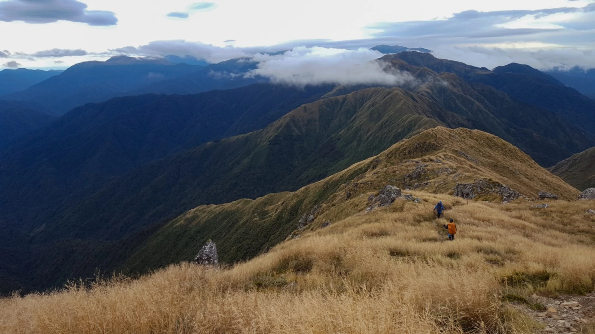
As you progress, the vegetation thins out, and the landscape becomes more alpine in nature. The trail becomes steeper and more exposed, with the next section leading to the Hector summit, one of the highest peaks in the Tararua Range. This part of the hike is particularly strenuous, with an elevation gain that will test your endurance.
Navigating the Ridge
Upon reaching the summit, hikers are rewarded with panoramic views of the surrounding valleys and peaks. The trail then follows a ridge line, which requires careful navigation, especially in poor weather. Hikers should be prepared with appropriate clothing and gear, as conditions can change rapidly. Using a navigation tool like HiiKER can help keep you on track and aware of your progress along the trail.
Descending into Otaki Forks
The descent from the ridge line towards Otaki Forks is steep and can be treacherous in wet conditions. The trail zigzags down the mountain, with the forest gradually becoming denser as you lose altitude. After approximately 38 kilometers, the trail concludes at Otaki Forks, a picturesque area with opportunities for camping and swimming in the Otaki River.
Historical Significance
The Tararua Range has a rich history, with the Southern Crossing being one of the oldest established routes. It was traditionally used by Māori for travel and trade. The rugged terrain has also been the site of numerous historical search and rescue operations, underscoring the importance of preparation and caution when undertaking this hike.
Wildlife and Nature
The Tararua Range is home to a variety of native flora and fauna. Hikers may encounter species such as the New Zealand falcon (kārearea) and the elusive morepork (ruru) owl. The forested areas are dominated by beech, rimu, and rata trees, which provide a canopy for the diverse understory of ferns and mosses.
Preparation and Safety
Given the trail's difficulty, it is essential to be well-prepared with adequate supplies, including food, water, and emergency gear. Weather in the Tararua Range can be unpredictable, so waterproof clothing and layers are necessary. It is also advisable to inform someone of your hiking plans and expected return time.
Conclusion
The Tararua Southern Crossing offers an immersive experience into the heart of New Zealand's natural beauty and rugged wilderness. With proper preparation and respect for the trail's challenges, hikers can enjoy a memorable adventure across one of the country's most iconic mountain ranges.

What to expect?
Activity types
Frequently asked questions
What is the Tararua Southern Crossing and how long is the hike?
The Tararua Southern Crossing is one of the four classic tramps in New Zealand’s Tararua Range. This point-to-point route is about 37.79 km long, with roughly 2,448 m of climbing, and it is usually completed over 3 days. DOC describes it as an advanced tramping track for experienced parties.
How hard is the Tararua Southern Crossing hike?
The Tararua Southern Crossing is an extra difficult multi-day hike with steep climbing, rough ground, mud, and a long exposed alpine section. The route reaches Mount Hector at 1,529 m and includes up to 8 to 9 hours of walking in a day, especially on the Alpha Hut to Kaitoke section. It is best suited to experienced trampers with strong navigation skills.
How many days does the Tararua Southern Crossing take?
Most parties allow 3 days for the Tararua Southern Crossing. A common breakdown is Otaki Forks to Field Hut in 3 to 4 hours for 5 km, Field Hut to Kime Hut in 3 to 4 hours for another 5 km, Kime Hut to Alpha Hut in 5 to 6 hours for 7.5 km, and Alpha Hut to Kaitoke in 8 to 9 hours for 17 km.
Where do the Tararua Southern Crossing start and finish points usually are?
The classic Tararua Southern Crossing usually runs between Otaki Forks and Kaitoke. On the Kaitoke side, access is from Marchant Road via Kiwi Ranch Road, where the car park is about 500 m along on the left. On the Otaki side, the route begins from the car park near the caretaker’s house at Otaki Forks, 19 km inland from Otaki township.
What huts are on the Tararua Southern Crossing route?
The main huts on the Tararua Southern Crossing are Field Hut, Kime Hut, and Alpha Hut. Each is a standard 20-bunk hut, with Field and Alpha Hut sitting just below the bushline on either side of the alpine section. Kime Hut is higher at 1,405 m and works as an alpine refuge, but it is known for being very cold in winter because it has no heating.
Can you camp on the Tararua Southern Crossing?
Camping is possible in Tararua Forest Park, but the Southern Crossing is most commonly done using the route’s backcountry huts rather than formal campgrounds on the tops. The key overnight stops on the crossing are Field Hut, Kime Hut, and Alpha Hut, and the exposed ridge between them is not a forgiving place in bad weather. Any camping plan needs to account for severe wind, mist, and freezing conditions that can occur at any time of year.
Are dogs allowed on the Tararua Southern Crossing?
Dogs are allowed on the Tararua Southern Crossing under DOC rules, but they must be kept under control at all times. That permission applies to the DOC-managed crossing itself, while access arrangements at trailheads and nearby park areas can differ. The route is long, steep, and exposed, so dog suitability is a practical issue as much as a rules question.
Comments and Reviews
User comments, reviews and discussions about the Tararua Southern Crossing, New Zealand.
4.88
average rating out of 5
8 rating(s)