Download
3D Flyover
Add to list
More
19.0 km
~5 hrs 42 min
1146 m
Multi-Day
“Trek through New Zealand's rugged Ruahine Range, encountering steep climbs, diverse wildlife, and rich Maori heritage.”
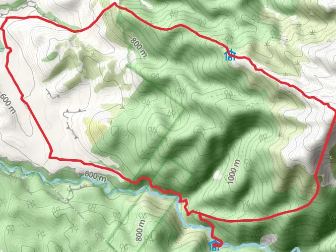
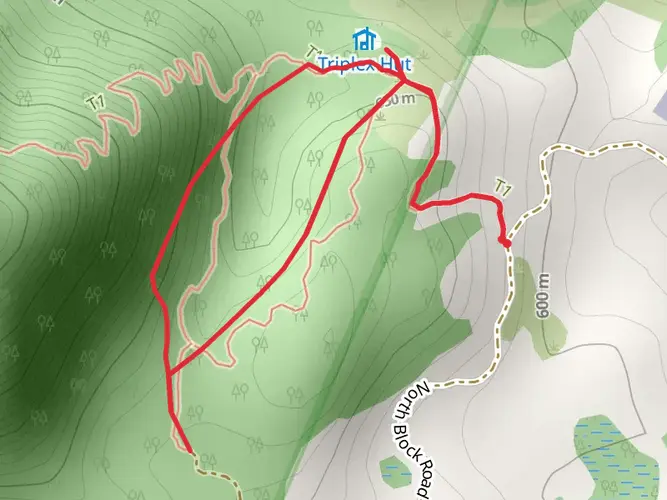
Embarking on the Makaretu Hut via Longview Hut and Eastern Ruahine Forest Park trail, hikers will traverse a challenging loop that spans approximately 19 kilometers (about 11.8 miles) with an elevation gain of roughly 1100 meters (around 3609 feet). This trek is not for the faint-hearted and is rated as difficult due to its steep sections and rugged terrain.
Getting to the Trailhead
The trailhead is accessible near Central Hawke's Bay, New Zealand. For those driving, the most common starting point is the end of Kashmir Road, which leads to the car park at the base of the range. If you're relying on public transport, options are limited, and it's advisable to check local services for the nearest drop-off points to the trailhead. From there, you may need to arrange a taxi or shuttle service to reach the starting point.
Navigating the Trail
The journey begins with a steady climb up to Longview Hut, which is situated at an elevation of around 1260 meters (4134 feet). This initial ascent covers a distance of about 5 kilometers (3.1 miles) and offers panoramic views of the surrounding landscape. Hikers should be prepared for potentially strong winds as they reach the exposed ridge line.
After reaching Longview Hut, the trail continues along the ridge before descending into the Makaretu Valley. This section of the trail can be quite steep and requires careful footing. The descent is approximately 4 kilometers (2.5 miles) and leads to the Makaretu Hut, a cozy shelter where hikers can rest or even spend the night.
Flora and Fauna
Throughout the hike, adventurers will be treated to the diverse flora and fauna of the Eastern Ruahine Forest Park. The park is home to a variety of native bird species, including the melodious tui and the curious kea, which may be spotted along the trail. The dense forest canopy is composed of beech, podocarp, and broadleaf species, providing a lush green backdrop for the journey.
Historical Significance
The Eastern Ruahine Range holds significant historical value as it was traditionally used by Māori for hunting and gathering. The area is rich in cultural heritage, and hikers are encouraged to respect the land and its history as they explore.
Return Journey
After leaving Makaretu Hut, the trail loops back towards the starting point, following the river and then climbing back up through the forest. This return leg covers the remaining distance, completing the loop. Hikers should be prepared for the ascent, which can be just as challenging as the initial climb to Longview Hut.
Preparation and Planning
Given the trail's difficulty, it's essential to be well-prepared. Hikers should carry a detailed map, and it's recommended to use the HiiKER app for navigation, as it provides up-to-date trail information and GPS tracking. Adequate water, food, and weather-appropriate clothing are a must, as conditions can change rapidly in the mountains. It's also wise to inform someone of your hiking plans and expected return time.
Safety Considerations
The trail can be treacherous in poor weather, with visibility and trail conditions deteriorating quickly. Hikers should check the weather forecast before setting out and be prepared to turn back if conditions worsen. It's also important to be aware of the signs of hypothermia and other hiking-related ailments, especially in the colder months.
By respecting the trail's difficulty, preparing adequately, and staying informed about the conditions, hikers can enjoy a rewarding experience traversing the Makaretu Hut via Longview Hut and Eastern Ruahine Forest Park trail.

What to expect?
Activity types
Frequently asked questions
How long does the Makaretu Hut via Longview Hut and Eastern Ruahine Forest Park hike take?
Makaretu Hut via Longview Hut and Eastern Ruahine Forest Park is a 18.99 km multi-day route with 1,146 m of climbing, so it is usually treated as an overnight tramp rather than a short day walk. The climb from Kashmir Road to Longview Hut alone is commonly described as a 2 to 3 hour ascent, and the full circuit includes steep ridge travel and a descent into the Makaretu Valley.
Where do you start the Makaretu Hut via Longview Hut and Eastern Ruahine Forest Park hike?
The usual start point for Makaretu Hut via Longview Hut and Eastern Ruahine Forest Park is the car park at the end of Kashmir Road in the eastern Ruahine area. Kashmir Road is a known access point into the high country, and the route from the road end climbs quickly onto an exposed ridge before dropping toward the Makaretu River and valley.
How hard is the Makaretu Hut via Longview Hut and Eastern Ruahine Forest Park hike?
Makaretu Hut via Longview Hut and Eastern Ruahine Forest Park is an Extra Difficult hike with 18.99 km of distance and 1,146 m of elevation gain. The route combines a steep climb to Longview Hut, exposed ridge sections, and a sharp descent into the Makaretu Valley, so it suits experienced trampers comfortable on rugged backcountry terrain.
Is there a hut on the Makaretu Hut via Longview Hut and Eastern Ruahine Forest Park route?
Yes. The route links two backcountry huts: Longview Hut high on the eastern Ruahine side and Makaretu Hut lower in the valley. Longview Hut sits at about 1,200 m elevation just below the ridge and is known for wide views across Central Hawke's Bay and toward the coast, while Makaretu Hut is reached after the descent toward the Makaretu River.
What is the climb to Longview Hut like on the Makaretu Hut via Longview Hut and Eastern Ruahine Forest Park hike?
The opening section of Makaretu Hut via Longview Hut and Eastern Ruahine Forest Park is a sustained climb from Kashmir Road to Longview Hut. That ascent is commonly described as steep and exposed in places, taking about 2 to 3 hours to reach the tussock tops and the hut, with strong winds possible once the route reaches the ridge.
Is the Makaretu Hut via Longview Hut and Eastern Ruahine Forest Park hike exposed to weather?
Yes. Makaretu Hut via Longview Hut and Eastern Ruahine Forest Park includes exposed ridge travel near Longview Hut, and the tops in this part of Ruahine Forest Park are known for strong wind and fast-changing mountain weather. The hut is tucked slightly below the ridge, but the approach and high sections can still feel very exposed in poor conditions.
Comments and Reviews
User comments, reviews and discussions about the Makaretu Hut via Longview Hut and Eastern Ruahine Forest Park, New Zealand.
average rating out of 5
0 rating(s)