Download
3D Flyover
Add to list
More
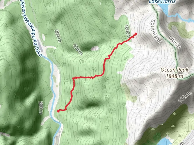
32.3 km
~2 days
2338 m
Multi-Day
“Embark on the Serpentine Range trail for a demanding yet stunning wilderness odyssey in New Zealand's alpine majesty.”
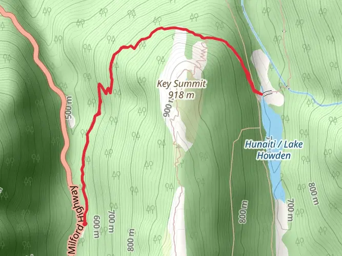
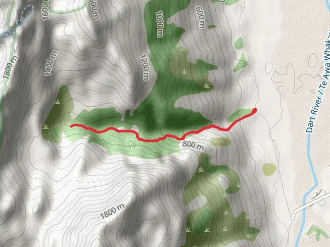
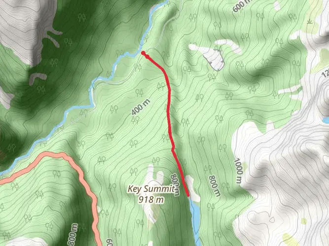
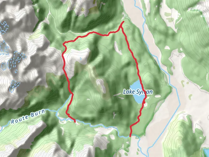
The Serpentine Range trail, nestled near Queenstown-Lakes in New Zealand, offers an exhilarating point-to-point hike spanning approximately 32 kilometers (about 20 miles) with an elevation gain of roughly 2300 meters (approximately 7546 feet). This challenging trek is not for the faint-hearted but rewards the intrepid hiker with breathtaking vistas and a true wilderness experience.
Getting to the Trailhead To embark on this adventure, hikers can reach the trailhead by driving or taking public transport to the vicinity of Queenstown-Lakes. The closest significant landmark to the trailhead is the renowned adventure hub of Queenstown, which is well-connected by road. From Queenstown, you can drive or catch a local bus service towards the starting point, which is situated in a remote area, so ensure to plan your transport accordingly.
Navigating the Trail Once on the trail, hikers should be prepared for a demanding journey that will test their endurance and navigation skills. It is highly recommended to use a reliable navigation tool like HiiKER to stay on track, as the trail can be challenging to follow in places. The path weaves through rugged terrain, with steep ascents and descents that are a constant companion throughout the hike.
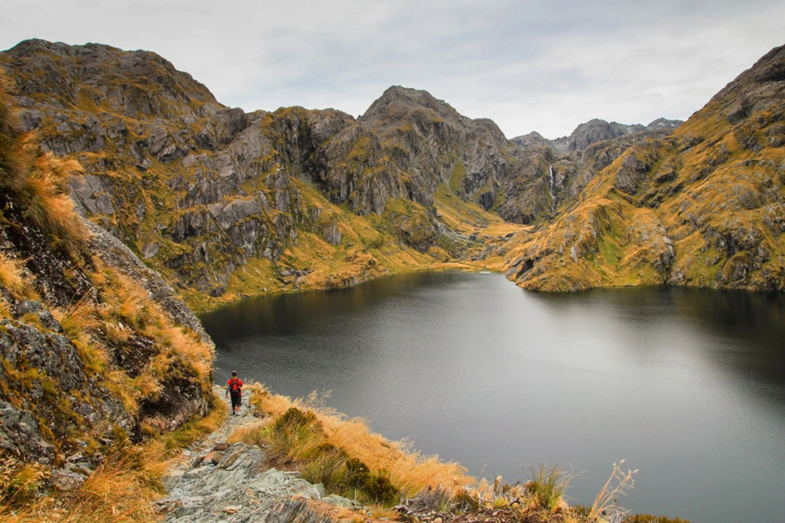
Landmarks and Scenery As you traverse the Serpentine Range, you'll be treated to an array of natural landmarks. The trail offers panoramic views of the surrounding mountains and valleys, with the Remarkables mountain range providing a stunning backdrop. The path itself winds through alpine meadows, subalpine shrublands, and across pristine mountain streams, which may require careful crossing after heavy rains.
Flora and Fauna The region is home to a diverse range of flora and fauna. Hikers may spot the kea, a native parrot known for its intelligence and curiosity, along with other bird species like the New Zealand falcon and the South Island robin. The plant life includes tussock grasslands and unique alpine flora, which can be particularly spectacular during the spring and summer months when wildflowers are in bloom.
Historical Significance The Serpentine Range holds historical significance as part of the Southern Alps, which have been shaped by centuries of Maori history and, later, by European exploration and settlement. The area has a rich gold mining past, and hikers may come across old mining trails and relics that speak to the region's heritage.
Preparation and Safety Given the trail's difficulty rating, hikers should be well-prepared with appropriate gear, including sturdy hiking boots, weather-appropriate clothing, and enough food and water for the duration of the hike. It's also wise to carry a first-aid kit, a personal locator beacon, and inform someone of your hiking plans due to the remote nature of the trail.
Conclusion In conclusion, the Serpentine Range trail is a challenging yet rewarding hike that offers a glimpse into the raw beauty of New Zealand's Southern Alps. With proper preparation and respect for the natural environment, hikers can enjoy a memorable experience traversing this majestic landscape.

What to expect?
Activity types
Frequently asked questions
How hard is the Serpentine Range hike in Queenstown-Lakes, New Zealand?
The Serpentine Range is an extra-difficult multi-day hike with 32.32 km of travel and 2,338 m of climbing. That combination points to a serious alpine route with long ascents, steep descents, and sustained exposure to remote mountain terrain rather than a casual day walk.
How long does the Serpentine Range traverse usually take?
The Serpentine Range covers 32.32 km with 2,338 m of elevation gain, so it is best treated as a multi-day traverse rather than a single short outing. Strong parties may move faster, but the distance, climbing, and route-finding demands mean most hikers should plan for at least an overnight trip and allow extra time for weather and navigation.
Can you camp on the Serpentine Range traverse?
Camping is commonly part of a Serpentine Range traverse because the route is a multi-day alpine trip, and trip reports for this area describe overnight camps near places such as Lake Nerine. In practice, camping here means remote backcountry conditions, so campsites are informal and weather exposure can be significant on and around the range.
What kind of route is the Serpentine Range traverse?
The Serpentine Range is a point-to-point alpine traverse in the Queenstown-Lakes area rather than a short loop. The route is associated with high-country travel above the Route Burn North Branch, with features such as Lake Wilson, Lake Nerine, and North Col appearing in established traverse descriptions for the range.
Is the Serpentine Range hike near the Routeburn Track?
Yes. The Serpentine Range sits above country linked to the Route Burn and Routeburn Track area, and published traverse descriptions connect the range with landmarks including Lake Wilson, Lake Nerine, and North Col above the Route Burn North Branch. That places it in the same broader mountain setting as one of the best-known hikes near Queenstown-Lakes.
What should hikers expect from navigation on the Serpentine Range hike?
Navigation on the Serpentine Range should be treated as advanced. The hike is rated extra difficult, spans 32.32 km, and follows remote alpine terrain where staying on the main ridge and linking features such as North Col or the high lakes demands strong map, compass, and GPS skills in poor visibility.
Comments and Reviews
User comments, reviews and discussions about the Serpentine Range, New Zealand.
4.14
average rating out of 5
7 rating(s)