Download
Preview
Add to list
More
15.0 km
~4 hrs 7 min
681 m
Loop
“A stirring Bennachie circuit of woodland, moor, and granite heights, crowned by Mither Tap’s ancient drama.”
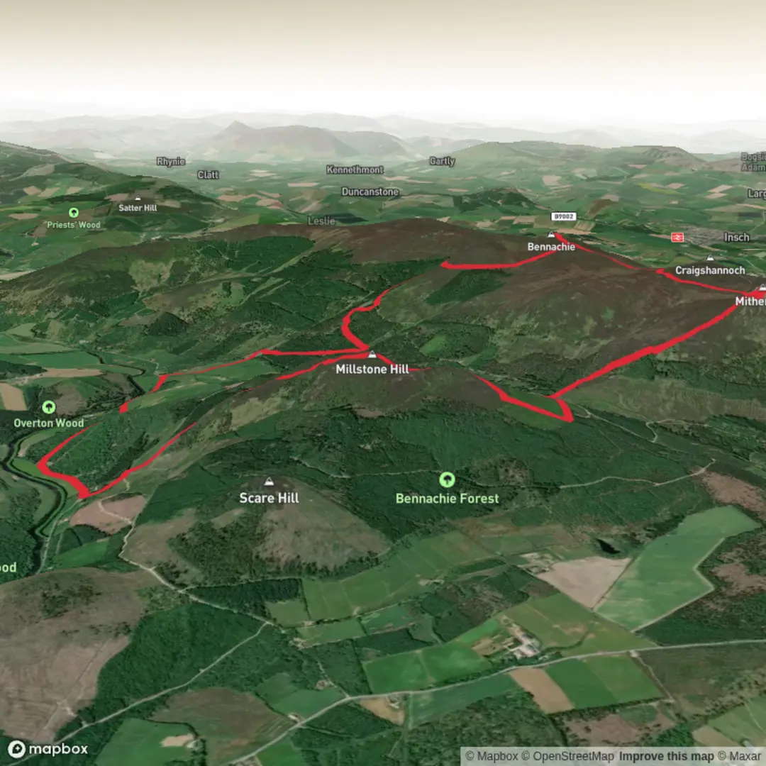
This 15 km / 9.3 mile loop on Bennachie’s eastern side packs a lot into a medium-grade day: a steady climb onto Millstone Hill, a more rugged traverse to the granite crown of Mither Tap, and a return through moorland and woodland paths near the Bennachie Visitor Centre. Expect around 700 m / 2,300 ft of ascent overall, which makes it more demanding than the distance alone suggests. The route combines good constructed paths, rougher hill sections, and exposed higher ground, so it suits walkers who are comfortable with sustained climbing and variable underfoot conditions.
The usual start point for this outing is the Bennachie Visitor Centre, just south of Chapel of Garioch, Inverurie, Aberdeenshire, which is the main access point for the eastern Bennachie trails. Forestry and Land Scotland gives the visitor centre car park at grid reference NJ 698 216, and the centre notes that it lies south of Chapel of Garioch and is well signposted from surrounding roads. Public toilets and visitor facilities are available here, making it the most practical base for a longer loop linking Millstone Hill and Mither Tap. (forestryandland.gov.scot)
By car, most walkers approach from Inverurie and follow local roads toward Chapel of Garioch and the signed Bennachie Centre. If using public transport, the nearest commonly referenced access point is Pitcaple on the A96, about 4.8 km / 3 miles from the visitor centre, so a bus-plus-walk approach is possible but adds extra distance before and after the hill route. (forestryandland.gov.scot)
The opening section is usually the most forgiving underfoot. Paths from the visitor centre rise through mixed woodland and lower slopes before the route commits to the broader shoulder of Millstone Hill, an outlying summit south of the main Bennachie ridge. Millstone Hill stands at about 409 m / 1,342 ft, and although it is lower than the main tops, it gives a strong sense of space early in the day, with wide views back across the Garioch and toward the more dramatic granite tors ahead. (walkhighlands.co.uk)
Terrain and route character
The climb to Millstone Hill is generally a sustained ascent rather than a scramble, but gradients can feel sharp in places, especially if the ground is wet. After rain, expect muddy stretches on lower paths and softer moorland sections higher up. Once beyond the more sheltered lower slopes, the route becomes increasingly exposed to wind. Bennachie catches weather quickly, and even on a clear day the higher ground can feel much colder than the car park.
From Millstone Hill, the loop becomes more serious. The traverse toward Mither Tap is where the route earns its medium rating: there is more ascent still to come, the ground can be rougher, and the sense of exposure increases. Mither Tap is the iconic summit of Bennachie at about 518 m / 1,699 ft, marked by a striking granite tor and the remains of an ancient hillfort. This is the visual and historical centerpiece of the walk, and the approach from Millstone Hill gives one of the best perspectives on its distinctive profile. (bennachievisitorcentre.org.uk)
The summit area is rocky and uneven, so care is needed in strong winds, mist, or icy conditions. In poor visibility, the various paths and desire lines around the hill can become less obvious, particularly where moorland and stony ground meet. For navigation, it is worth checking the route carefully on HiiKER before setting out and keeping an eye on junctions rather than assuming the most worn line is always the correct one.
Landmarks, history, and atmosphere
Mither Tap’s hillfort is one of the most important historic features in northeast Scotland. The summit fortification consists of substantial collapsed stone ramparts wrapped around the granite top, and it is widely described as a Pictish fort or prehistoric hillfort. Archaeological interpretation has linked the site to a major power center in the region, and the fort’s commanding position makes that easy to understand once on the summit: it dominates the surrounding landscape and would have been visible for miles. (bennachievisitorcentre.org.uk)
The wider Bennachie range also carries deep cultural significance in Aberdeenshire. Mither Tap is the most recognizable peak in the range, while Oxen Craig, at 529 m / 1,736 ft, is the highest. Bennachie has long been a landmark for the surrounding farming country, and its profile is one of the defining horizons of the Garioch. (bennachievisitorcentre.org.uk)
As the loop turns away from the summit and begins descending, the character shifts again

Surfaces
Unknown
Asphalt
Unpaved
Comments and Reviews
User comments, reviews and discussions about the Millstone Hill, Mither Tap Fort and Bennachie Loop, Scotland.
average rating out of 5
0 rating(s)