Download
3D Flyover
Add to list
More
11.4 km
~2 hrs 48 min
321 m
Loop
“Reservoir reflections, heather moors, and a windswept summit make this a quietly rewarding upland loop.”
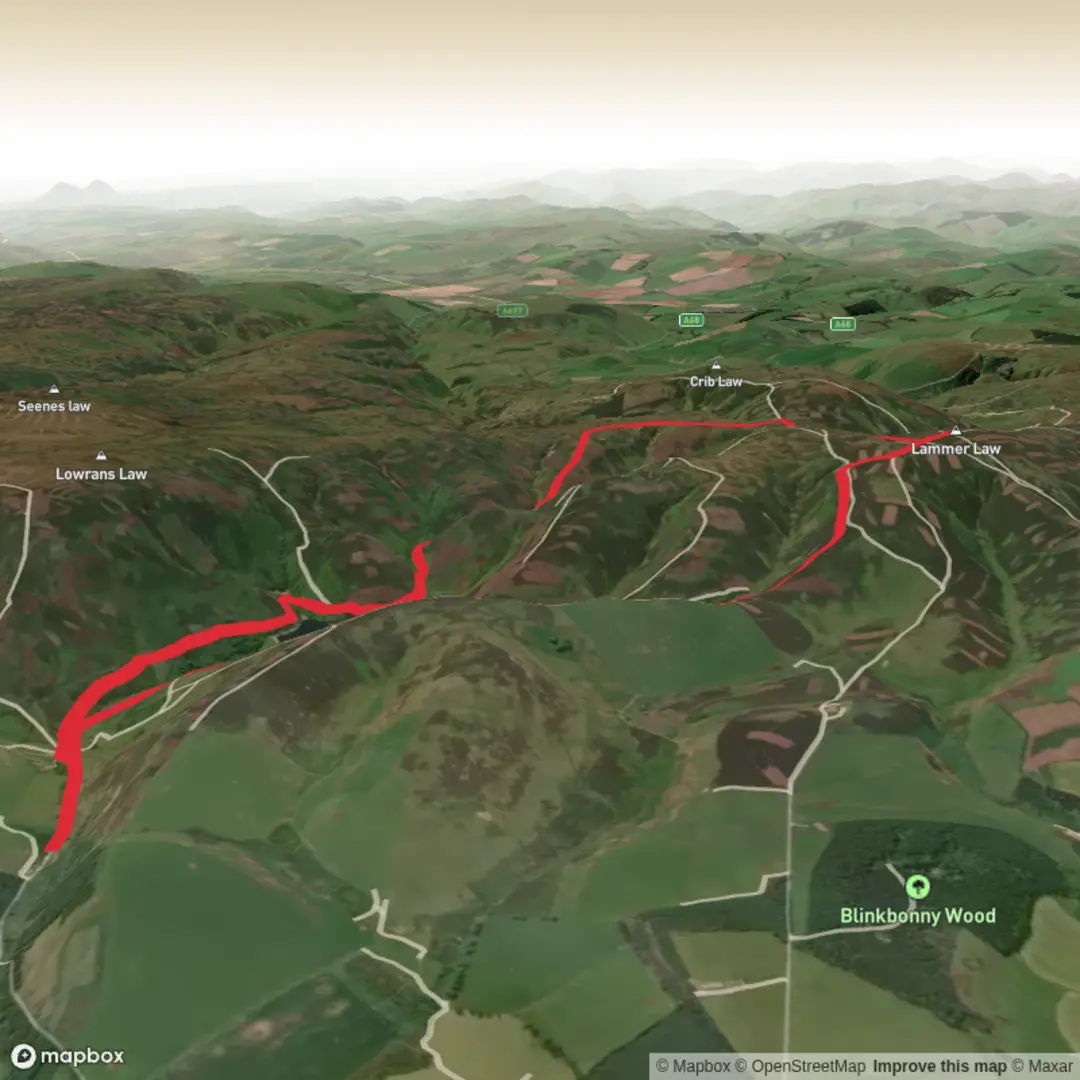
This medium-grade loop in the Lammermuir Hills gives a fine mix of reservoir shoreline, broad moorland tracks, open hill walking, and a short rougher pull onto one of East Lothian’s best-known summits. Expect roughly 11 km / 6.8 miles overall if you follow a shorter version of the circuit, with about 300 m / 985 ft of ascent, though mapped variants in the area are often a little longer at around 13.7 to 14.5 km / 8.5 to 9 miles with 352 to 405 m / 1,155 to 1,329 ft of climbing. (hiiker.app)
The route is set in the uplands south of Gifford, East Lothian, near Hopes Reservoir and the minor road end by Blinkbonny Wood / East Hopes, which is the most useful known landmark for the start area. Walkhighlands places the start at the end of the minor road past Blinkbonny Wood near Longyester, with grid reference NT541642. (walkhighlands.co.uk)
Getting to the start is easiest by car. From Gifford, roads head south into the Lammermuirs toward East Hopes and Blinkbonny Wood, where roadside space is limited and should be used carefully and legally. Parking arrangements around Hopes Reservoir have changed over time, and some nearby parking has been restricted or permit-based, so it is worth checking access and planning your exact start point before setting out. Public transport is poor: there is effectively no direct service to the trailhead, and the wider Lammermuir area has no through public transport, so most walkers combine a bus to Gifford or nearby East Lothian settlements with a taxi, cycle approach, or a much longer walk-in. (walkhighlands.co.uk)
What the route feels like
From the road end, the walk usually begins on estate and hill tracks that climb steadily into open country. Early on, the gradients are generally manageable rather than severe, making this a good route for hikers comfortable with a few hours on mixed terrain but not looking for scrambling or exposed ridge work. The landscape opens quickly, with long views north toward lower East Lothian and, on a clear day, toward the Firth of Forth. (walkhighlands.co.uk)
As height is gained, the route becomes more exposed to wind and weather. The Lammermuirs are rounded rather than dramatic, but they can feel very remote in poor visibility. Underfoot, much of the circuit uses good land-rover tracks or clear hill paths, but the approach to Lammer Law itself is often the trickiest section. Several route descriptions note boggy ground and wet trods near the summit approach, so waterproof footwear and gaiters can be very helpful after rain or during wetter seasons. If using digital navigation, HiiKER is the best tool to keep the line of the loop clear where paths become faint across the moor. (hiiker.app)
The climb to Lammer Law is the high point of the day in both senses. Although not the highest hill in the Lammermuir range, it is the best known, crowned by a large cairn and trig point. The summit section is broad and open rather than narrow or airy, so the challenge is more about weather, wet ground, and navigation than technical difficulty. (walkhighlands.co.uk)
Landmarks, scenery, and wildlife
One of the defining landmarks is Hopes Reservoir itself, a compact but striking body of water tucked into the folds of the hills. The return leg beside or above the reservoir is often the most picturesque part of the circuit, especially when the water reflects the surrounding moorland and the slopes of Lammer Law. The glens and cleughs around the reservoir are part of a valued landscape noted for their upland scenery, heather moorland, and pockets of native woodland in the burns and gullies. (walkhighlands.co.uk)
Wildlife is typical of East Lothian uplands. Red grouse are associated with the surrounding moorland, and the reservoir has been stocked with brown trout. Birdlife can vary with season, and the open hills can also hold raptors, so carrying binoculars is worthwhile if you enjoy scanning the skyline. Around the burns and cleughs, look for wetter ground vegetation and more sheltered strips of willow, birch, and alder. (en.wikipedia.org)
Rogers Cleugh adds a more enclosed feel to part of the loop, contrasting with the broad, open summit slopes. In Scots place-names, a “cleugh” usually refers to a steep-sided ravine or gully, and that helps explain the terrain here: expect a change from wide moorland openness to a more folded landscape shaped by water and erosion. The

Surfaces
Unknown
Gravel
Comments and Reviews
User comments, reviews and discussions about the Hopes Reservoir, Rogers Cleugh and Lammer Law Loop, Scotland.
average rating out of 5
0 rating(s)